|
 Prehistoric Egyptian Geodesy:
It has been suggested that the temples of
prehistoric Egypt were located according to geodetic principles. As
these include some of the greatest structures ever built, and with
such precision and purpose, it is worth investigating this
suggestion seriously.
Although Piazzi Smyth may not have been the first European to suggest
that the Giza complex had been built for a particular reason, he was the first person to bring the idea
to the scientific forum. He concluded that Giza was deliberately
placed both on the 30th parallel and at the centre of the old-world
continents as a geodetic marker
for the ancient world-meridian.
The separation of other sacred sites from this location by exact
units of degrees and geometry, supports this claim.
'I have grasped the stake... I take the measuring cord in the
company of Seshat. I consider the progressive movements of the
stars. My eye is fixed upon the Bull's Thigh [Ursa Major]. I count
off time ..... and establish the corners of the Temple'.
The above text is an inscription from the Temple of Horus at
Edfu accompanying the relief showing "Stretching the Cord"
Ceremony.
|
Prehistoric Egyptian Geodesy: |
The
numerous successes of ancient Egypt have made it a modern day icon for
pre-historic achievement and although today we look back on Egyptian
achievements with an sense of wonder, we still have no definitive context into which to
place them. There have been several serious suggestions that an elite of prehistoric
Egyptians were already party to a sophisticated set of knowledge that included
geometry and astronomy.
The 'Stretching of the Cord'
ceremony is mentioned in some of the earliest Egyptian texts in relation to pyramid
building. The ceremonial nature of the procedure adds credence to the
idea that any knowledge of geometry and astronomy at that time was an
'elite' science.
The Giza Complex:
The specific placement of the
Giza
complex on the 30th parallel has long led people to suspect
that it was constructed at that location according to deliberate
geodetic placement. Piazzi Smyth suggested that the Giza complex
identified an ancient 'meridian' as long ago as 1864. The
latitude of Giza at 30� N, has been shown to have a geometric
relationship with other sacred
Egyptian complexes (see above), which in itself is suggestive of a deliberate geometric
system of placement. However, the latitude of 30� has its own
geometric significance, representing 1/3rd of the way from equator to
pole and a 1/12th division of the circumference of a circle. This
division can be seen in both the measure of time and space (there are 12
solar months in the year, 24 hours in each day, and 12 astrological
signs in the heavens).
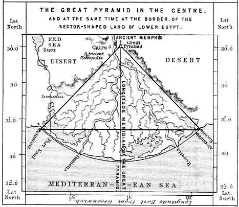
The exterior angle of the Great pyramid is replicated in the
angle of the Nile Delta, and is also exactly 1/1000th scale with
Alexandria and Port Said (Left). The Great Pyramid of Giza is
also a 43,200 scale representation of the outline of the northern
hemisphere of the earth (Right).
The
circumference of the Great pyramid is exactly one-half minute of a degree of latitude
at the equator.
The
pre-eminent Egyptologist, Ludwig Borchardt commented on an Egyptian
inscription stating that the distance between Behdet (at the northern
tip of the Nile Delta) and Syene (at the first cataract near Aswan in
the south) was 106 atur, "one must absolutely exclude the possibility
that the ancients may have measured in degrees." In the case of
Borchardt's quote, if one simply checks the distance, it does in fact
measure 106 geodetic atur. An atur was 15,000 royal cubits, which was
also equal to 17,000 of the older geodetic cubits. The figure 106 atur
is significant because it is 1/12 of the length of the meridian from the
equator to the pole. (5)
Giza and the 30th Parallel.
We have seen that the centre of the
Piri-reis map was in
the region of Syene, the south-westerly point of Egypt.
The geometry used in the map is - in effect, the
cartographer's fingerprint. It shows a division of 360� and uses a
system known as the 'twelve-wind' system, (based on an 8x8 grid).
It is perhaps not so strange that we find this very same geometry in the
ground-plan of Giza.
The meticulous
measuring of the Giza complex by Petrie, Smyth and others, has
illuminated the extent of the geometry at Giza (Click here for more),
but there is a simple geometry behind the Giza layout which returns us
again and again to 30�, a figure associated with an 8x8
grid as noted by John Michel
(3),
who mentions
'Levi's magic squares' of which there was one for each planet,
and that each of the seven wonders of the ancient world represented a
planet, and that Giza represented Mercury 'the messenger', whose square
was an 8x8). While this may be a coincidence, it seems worth
mentioning.
 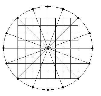
It can be seen
that the 8 x 8 grid used for the layout of the Giza pyramids (above,
left) simultaneously reveals the 5:8 ratio between the corners of the
three pyramids (which are aligned to Heliopolis), otherwise known as the 'sacred mean', and
a symbolically relevant geometric figure. and including
sufficient geometry to create 12 equal divisions of 30�, as seen both
between pyramids and in the actual location of Giza (along the 30th
parallel).
It can
also be seen from the diagram (above, right), that the basis for the
Giza ground-plan mirrors Hapgood's method for determining the centre of
the Rose-de vent's on the Piri-reis map. (It is a simple matter of
rotating the 8x8 grid in order to find the missing four points)
The preference for the placement of other ancient sacred sites along the
30th parallel, (all of which lie to the east of Giza, and none to the
west) is clear. A tradition which can be clearly traced back to at least
3,000 BC.
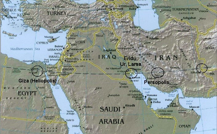
Persopolis was placed 21� 36'
(3 x 7� 12') East of Giza, while Lhasa in Tibet, was placed exactly 30�
East.
T he
location of the Persopolis complex
(30� 00' N, 52� 50' E)
is curious for several reasons, not least the complete lack of housing
in a citadel of temples and shrines in a place essentially built in the
middle of nowhere, suggesting
the site functioned in a 'sacred' capacity. Hancock's suggestion
that Persopolis was deliberately sited 7� 12' from
Giza,
finally explains the reason for the location of Persopolis, which was
until then considered a
mystery, as the city seems to have been built inexplicably far from any other known contemporary ancient cities or
urban centres.
The angle of 7� 12'
is equal to 1/50th of the circumference of the earth, and
was the angle of the shadow cast by the northern edge of the sun at noon
on the summer solstice in Alexandria as reported by Eratosthenes.
Heliopolis:
Although the Giza complex is generally considered the
Geodetic centre of Egypt, it is just one of several (3rd-6th dynasty) pyramid complexes in the region
which shared a specific architectural feature in common, suggesting allegiance to a centre of greater magnitude, namely -
Heliopolis (On in the Bible).
The pyramids built at these sites built between the
3rd-6th dynasties have their corners aligned in the direction of
Heliopolis, while those built before or after, while still showing a
preference for corner alignments, no longer do so towards Heliopolis. For this reason, and
because of closer proximity to the 30th parallel, Heliopolis might well
have be
considered the true geodetic centre by ancient Egyptians.

(More about
pyramid alignments)
In addition, Giza (Heliopolis) shares several other close
geometric and geodetic connections with other important ancient and
sacred sites. Of particular interest is the association with Baalbek
(Also called Heliopolis) in Lebanon, which is exactly
4�
North and 5� East.
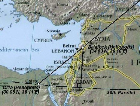
Heliopolis:
(30� 06'
N, 31� 11' E) - Baalbek:(34� 03' N,
36� 10' E).
|
Egyptian Sites
with a Geodetic Significance. |
Several of the most significant complexes in Egypt share a geometric
relationship with each other...
(Giza):
Capital of Early Dynastic Lower Egypt.
(29� 58' 51" N).
Giza (Heliopolis) to
the Equator = 1/12th the circumference of the earth. (360�/12 = 30� 00�).
'The apparent placement of these of these other sites in relationship
to the meridian of the Great Pyramid becomes even more understandable
when we recognize that the Great Pyramid was located at 30* north
latitude (currently 29�
58' 51"). At first glance it appears that the builders made an error
of 1' 9" in its location. However, without a correction for atmospheric
refraction, 29�
58' 22" north latitude appears to be exactly 30*, based on purely
astronomical observation. Thus there could instead be an error of 29" in
the other direction. Or, there could be an error of only 20" if, as
Piazzi Smyth suggests, they had intended to split the difference and try
for the intermediate value of 29� 59' 11". This idea becomes more
plausible when one realizes that the atmospheric error is in the
opposite direction for an alignment based on solar observations, and
thus it would make sense that they might have used an intermediate value
between the solar and stellar calculations. It is equally likely that
they simply could not place the Great Pyramid any farther north, and
still remain on their prime meridian bisecting Egypt, because the Giza
Plateau ends. As it stands, the Great Pyramid is closer to the cliff at
the northern edge of the Giza Plateau than many engineers would have
thought feasible. It is even remotely possible that the earth's crust
has shifted slightly over the intervening 4500 years and the Pyramid was
originally placed at a minutely different latitude. In any case, the
precision with which it is placed is astounding, certainly more than
accurate enough to prove both their intention and their ability'.
(5)
Amarna.
Temporary Capital of Middle Dynastic Egypt. (27�
38� N)
Armarna to Equator = 1/13th of
the circumference of the earth. (360�/13 = 27� 41�).
In 1350 BC Akhenaten unexplainably moved his capital
from
Luxor
(Thebes) to Amorna.
'Modern excavations indicate that the southern boundary of Amarna was
close to 27� 36' north latitude, precisely half-way between the latitude
of Alexandria and the latitude of the southern border of ancient Egypt
at Philae. The southern boundary of Amarna is 3.6� south of Alexandria,
precisely 1/100th (one percent) of the 360� circumference of the earth
and, Amarna is also 3.6� north of Philae, also precisely
1/100th (one percent) of the 360� circumference of the earth'.
(4)
The northern boundary of the city would have been close to to 27�
41' N The distance from 27� 41' N to the equator is one-thirteenth of
the circumference of the earth:
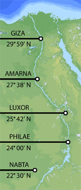 Thebes
(Luxor):
Capital of Early Dynastic Upper
Egypt.
(25�
42� N) Thebes
(Luxor):
Capital of Early Dynastic Upper
Egypt.
(25�
42� N)
Thebes
to the Equator = 1/14th of circumference of the earth.
(360�/14 = 25� 42�).
Thebes was considered the spiritual centre of 'upper'
Egypt, and was equalled in importance only Giza/Heliopolis in the North.
It is related to other sites both through geometry and geodesy,
supported by myth and the historical memoirs of Herodotus.
Philae
(Syene): �The
first cataract�. (24� 00� N).
�First cataract� to the Equator =
1/15th of the circumference of Earth. (360�/15 = 24� 00�)
The official southern border of ancient Egypt.
Nabta Playa: Megalithic stone circle/complex (22� 32� N).
Nabta to the Equator = 1/16th
of the circumference of the Earth. (360�/16 = 22� 30�).
Only megalithic remains of its kind in Egypt.
(c. 4,000 BC),
Built close to the Tropic of Cancer.
|
The Piri Reis Map: An Egyptian Legacy? |
Although several uncertain claims have been
made concerning the Piri-reis map, there was one interesting result from
Hapgood's research which has a significant bearing on this subject.
The accuracy of the map in terms of longitude and latitude made it
possible to calculate the cartographic centre, which was found to be ...
Egypt.
The centre of the map
-
Although only the left-third of the map now remains, the remaining 'Rose
des vents' on the map enabled Hapgood to project for the
cartographic centre (see below), which was calculated to fall in 'the
region of Syene', in Egypt, and following a series of more accurate
tests he determined that the centre of the map was situated on the
ancient Tropic of Cancer, and on the same Meridian as later Alexandria
(at 30� longitude).
The
longitude reading is easily explained in terms of the prehistory of the
Nile valley, but the latitude is far easier to explain in terms of
astronomy or geodesy.
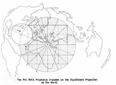
Centre of Piri-reis map - (24� 06� N, 30� 00�
E).
The suggestion that the latitude was chosen because of its
astronomical relevance is of interest as the latitude of the Tropics is
known to have changed over time. In fact, at the time of Eratosthenes
for example, the Tropic of Cancer was at 23� 45� N, and the region of Syene, or rather, Elephant island on the Nile, which is situated at 24�
06� N, would no longer have functioned as a marker of the suns vertical
rays in his time, and the only time it would have worked in the way
described would have been at around (3,000 BC). The latitude of 23�
30� has only been applicable in recent times which makes the fact that
it centered on the region of Syene very significant.
Syene is on the same latitude as modern day Alexandra
-
30� 00� E. They define the
western extremes of ancient Egypt.
There have been several suggestions that geodetic
measurements were observed in Egypt before the Greeks, For example,
Strabo the
Geographer stated that �the science of land-measuring
originated along the Nile in Egypt' (Book XVII), from a necessity to record the boundaries of the nomes
(provinces) of the country, and it is suspected from the placement of
sacred Egyptian cities and shrines (as seen above) that a knowledge of the earth
as a
globe, its dimensions and a division into 360� existed in ancient
Egypt (as seen in the Piri-reis map - Eratosthenes later
divided the globe into 60
divisions of 6�).
In relation to this, the diameter of the circle formed by the
Rose-des-vents on the Piri-reis map was calculated to cover 69.5� of
the earth surface (approx 4% less than 72% - or 1/5th - as
per the Eratosthenes error - which could be eliminated if the angle of
the ecliptic were extended to 24� 45�). So
that, while we are
comfortable in assuming that the maps of Eratosthenes and Ptolemy
provided all the necessary information for latter generations to pick up
on (as they did), eventually leading to the production of the Piri-reis
map and others, a deeper root has appeared, which points back to earlier
activity, and perhaps justifies Hapgood�s theory of the existence of an
�set of ancient knowledge' in the maps.
(More about the Piri-Reis Map)
The alignment of sites from Giza (Heliopolis) is not
restricted to the 30th parallel as geometric alignments have been shown
to extend from both Giza (Heliopolis) and Karnak (Thebes), to other
sacred sites beyond Egypt. The example already demonstrated above
between Giza and Baalbek, is in fact only a part of a larger alignment
which extends for almost exactly 1000 miles directly towards Mount
Ararat (as first observed by Livvio Stecchini). While these long distance alignments are notoriously
difficult to trace, the Giza (Heliopolis) - Baalbek (Heliopolis) section of the
alignment is reinforced by supporting evidence; Namely, both sites were
equinoctial, they both show the same incredibly skilled masonry
techniques, and they are
separated by almost exact degrees of longitude and latitude, Baalbek
being located 4� North and 5� East.
The extreme length of this alignment would normally
preclude it from investigation, but in this case, there is supporting
evidence which makes it worth a closer look. Stecchini has already made a strong case for the connections between
oracle centres and Egypt, with Karnak (Thebes) being the oracular centre
and 'earth-navel' of ancient Egypt, as testified by the 'Omphalos'
discovered at Karnak. It is significant then that Dodona in Greece is
both named as the oldest oracle centre in Greece (with a connection to
Thebes supported by Herodotus), as the landing place for Deucalion
following the 'Flood of Deucalion' in Greek mythology, while
Ararat is clearly named as the landing place for the Ark in the Old
Testament, as they both share the same latitude...and are located
equidistant from Thebes.
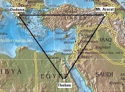
Herodotus recorded that an oracle site was formed at
Dodona following instructions from the Oracle at Thebes.
�Two black doves
flew away from Egyptian Thebes, and while one directed its flight to
Libya, the other came to them. She alighted on an oak, and sitting there
began to speak with a human voice, and told them that on that spot where
she was, there should thenceforth be an oracle of Jove (Zeus). They
understood the announcement to be from Heaven, so they set to work at
once and erected a shrine. The dove that flew to Libya bade the Libyans
to establish there the oracle of Ammon (Amon).�
(Herodotus II,
53-5).
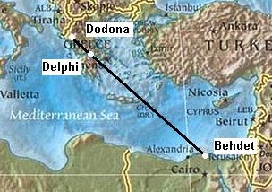 Dodona
in Greece is also aligned with Delphi and Behdet (the prehistoric
capital of Egypt according to Stecchini) in what he called the 'Oracle
Octave'. Dodona
in Greece is also aligned with Delphi and Behdet (the prehistoric
capital of Egypt according to Stecchini) in what he called the 'Oracle
Octave'.
Significantly,
Stecchini
stated that the pre-dynastic capital of Egypt, Behdet 'existed before
3,200 BC', and was replaced by the city Canopus, (The same name
as the star that represents the 'rudder' of the constellation Argo).
He suggested that this was the key to the connection between the two
mythological narratives of the �Ark� of the Hebrews and the �Argo�
of the Argonauts, which he believed, revealed evidence of a prehistoric
system which included an understanding of astronomy and
geo-metry (in the sense earthly measurements).
(More about the Oracle centres)
The European Connection:
An alignment is commonly said to run from Giza to the
Boyne-Valley, Ireland. Although the accuracy of this alignment is
debateable, it nevertheless passes several of the most important places
in Europe, both past and present: From Giza it runs north-west towards
Rome (Vatican city), Zurich, Paris (Par-Isis), the Salisbury complex and
on to the Boyne Valley.
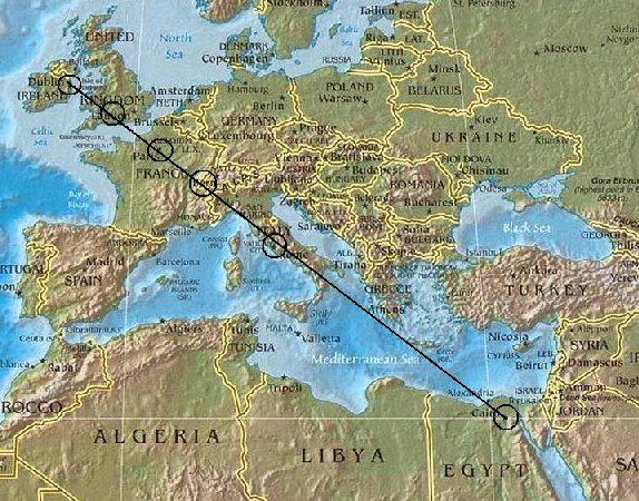
The ancient eastern and western borders of Egypt were separated by
exactly 1� 09� separation. Coincidentally the same as the distance
between the Paris and Greenwich meridians.
The distance from Khufu's Great Pyramid to Tara Hill is
one-tenth of the planetary circumference (36.00�), while the
distance from Avebury to Tara Hill is one-hundredth of the planetary
circumference.
It has been shown that Egypt played a part in
the placement of certain Oracle centres, both
in Greece and the Middle-east (above). This idea is reinforced by the apparent
geodetic placement of
Knossos, which has been noted by others (Manias, Stecchini etc),
as it sits
almost exactly 5� north and 4� west of Giza (Heliopolis).
Knossos
� (35� 17� N. 25� 09� E)
Middle-Eastern Connections;
Baalbek: While these long distance alignments are notoriously
difficult to trace, the 'Heliopolis' alignment (above), is reinforced by supporting evidence; Namely, both sites were
equinoctial, they both show the same incredibly skilled masonry
techniques, and they are
separated by almost exact degrees of longitude and latitude, Baalbek
being located 4� North and 5� East.
Baalbek - (34� 10' N, 36� 10' E)
Knossos: It has already been suggested that Egypt played a part in
the placement of certain Oracle centres, both
in Greece and the Middle-east. This idea is reinforced by the apparent
geodetic placement of Knossos, which has been noted by others (Manias, Stecchini etc),
as it sits
approximately 5� North and 4� West of Giza (Heliopolis).
Knossos
� (35� 17� N, 25� 09� E)
Hattusa: Location of the Hittite empire and before them the Hatti.
Hattusa was arguably one of the most important in the region for well
over a thousand of years, even though it sits on top
of a barren and wind-swept plateau at 1,200 meters above sea level,
which enjoys what is possibly the worst weather conditions in central
Anatolia. Even in April the site is mostly covered by snow,
Hattusa - (40.02� N, 34.2� E)
Nippur: One of the oldest Sumerian cities, and one with a
Ziggurat, Nippur was continuously occupied from around 5,000 BC to
800 BC. It is located
approximately
2� North and 14� East of Giza.
Nippur - (32� 17' N, 45� 16' E)
Nimrud,
the capital of Assyria:
Stecchini said of it:.
'Egyptian benchmarks had the shape of the �navel� found at the
Temple of
Delphoi in
Greece. These �navels� had the shape of a hemisphere
with the meridians and parallels marked upon them; at times they are
half a sphere and at times they are elongated at the Pole. The sanctuary
of Delphoi was considered a �navel of the earth,� as being located at
3/7 of the distance from the Equator to the Pole. This would correspond
to a latitude 38� 34� N; the Temple of Delphoi is actually located at a
latitude 38� 29� N, � which makes it 6� to the North of one of two
Egyptian anchor points, the original apex of the Nile Delta at latitude
30� 05� N on the axis of Egypt which is 31� 13� E. Susa was computed as
being 17� to the East of this point; it is at latitude 48� 15� E. When
the Assyrians established their religious capital at
Nimrud in 875 B.C. they chose a point that was 6� to
the North and 12� to the East of this Egyptian anchor point.(2)
 Nimrud - (36� 06�
N, 43� 20� E) Nimrud - (36� 06�
N, 43� 20� E)
As well as
being exactly 6� north and 12� east of Giza, Nimrud shares another remarkable
mathematical parallel with another Egyptian feature, which is that the longitude of Nimrud is
on the exact
same angle as that exterior angle of both of Snoferu�s pyramids.
This particular feature is also seen in the relationship
between The Great pyramid and
Silbury hill; with each others
exterior angles being reflected in the others latitude.
This particular revelation begins to reveal a pattern in
which the exterior angles of certain pyramids (those of the 4th and 5th
dynasties in particular), appear to demonstrate angles with mathematical
significance.
The Great pyramid and Silbury hill share this
particular feature in an intimate fashion. The Great pyramid has an
exterior angle of 51�
51', which is the latitude of Silbury hill and the result of 90�/7
(x4). Silbury hill has an exterior angle of 30�,
the same as the latitude of the Giza complex.
(More
about Pyramid Geometry)
(The World Grid)
(Prehistoric
British Geodesy)
(Geodesy
Homepage)
(Ancient Egypt Homepage) |