|
 The World Grid:
(Prehistoric Geodesy)
The World Grid:
(Prehistoric Geodesy)
|
It has been suggested that there once
existed a network of aligned sacred and ancient sites that composed what
is commonly termed today 'The World-Grid'.
The obvious propensity for
straight lines in prehistory is demonstrated by the numerous 'ley-lines'
and geometric alignments around the ancient world. It is also common to find
that such alignments connect prehistoric sites together, which is one of the
main arguments put forward to supports the idea of the existence of a
prehistoric 'world grid'.
|
 |
|
What Exactly is the World-Grid: |
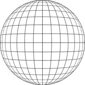
The basic essence of a world
grid is the intellectual division of the surface of the world into a
mathematically predictable model. There are several theories already in
place to explain the existence of such a 'world-grid', should it ever be
confirmed.
The idea of the earth as a geometric shape goes back in
history at least to the Pythagorean school of thinking in ancient Greece.
Its famous adherent, Plato, wrote that �the earth, viewed from above,
resembles a ball sewn from twelve pieces of skin'.

'Because of the advanced geodetic and
geographic science of the Egyptians, Egypt became the geodetic centre of the
known world. Other countries located their shrines and capital cities in terms
of Egyptian 'zero' meridian, including such capitals such as Nimrod, Sardis,
Susa, Persepolis, and apparently, even the ancient Chinese capital of An-Yang...
As each of these geodetic centres was a political as well as geographical
'navel' of the world, an Omphalus or stone navel, was placed there to represent
the northern hemisphere from equator to pole, marked out with meridians and
parallels, showing the direction and distance to other such navels'.
Extract from Peter Tompkins 'At the Centre
of the World'
(1)
The works of Eratosthenes and Plato leave no question that the Greeks knew
the earth was round, and divided it by 360�. But although they are often
credited with the 'invention' of this now global-standard division of
both time and space, the roots of such knowledge are today in question.
As the Greeks themselves wrote that they obtained much of their knowledge
from Egyptian and Babylonian sources, it should come as little surprise to
find that the placement of the most sacred centres of ancient Egypt appears
to echo a placement according to a geometry based on earthly measurements, a
process which can be seen repeated around the prehistoric world, and through
perhaps offering a clue to the underlying origin of the science itself;
Astronomical observation.
Geodesy and the World-Grid:
There is a fundamental difference between Geodesy and the World Grid,
in that the
Grid is based on a geometrically uniform pattern, whereas geodesy is also
concerned with 'energy lines' and topographical features.
(More about Geodesy)
According to Webster's
dictionary, a grid is defined as:
"a network of
uniformly spaced horizontal and perpendicular lines, specifically one
used for locating points by means of a system of coordinates."
|
Proposed Examples of the world-Grid: |
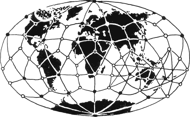
View of the Earth
as a 'Giant Crystal' as envisioned by a group of three Russian
scientists in the 1960's.
Their findings were
published in 'Khimiya i Zhizn', the popular science journal of
the Academy of Sciences, entitled 'Is the Earth a Giant Crystal?. They
decided that there was nothing in theory to prevent a lattice-working
pattern - a 'matrix of cosmic energy' as they put it - being
built into the structure of the earth at the time when it was being
formed, whose shape could still be dimly perceived today.
According to their
hypothesis, the crystal can still be seen in twelve pentagonal slabs
covering the surface of the globe (a dodecahedron as suggested by
Socrates who said 'The real Earth viewed from above is supposed
to look like one of those balls made of twelve pieces of skin sewn
together'), overlaid with twenty equilateral triangles. The
entire geometric structure, they claim, can be seen in its influence
on the siting of ancient civilisations, on earth faults, magnetic
anomalies, and many other otherwise unrelated locations which are
placed either at the intersections of the grid, or along its lines.
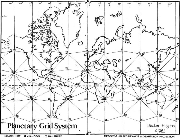
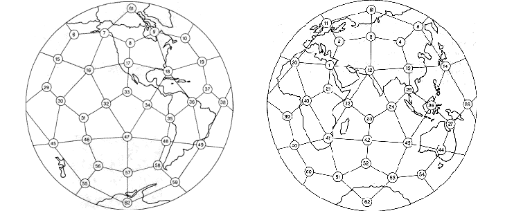
The Becker-Hagens
Icosahdron Projection.
(1. Great Pyramid at
Giza, Egypt), (11. Orkney Islands, Scotland), (18. Bermuda
triangle, Bahamas), (47. Easter Island),
David Zink's map of
megalithic sites and other features from his book The Ancient Stones
Speak, (Dutton, 1979).
(1) Giza, the Great Pyramid.
(9) Hudson Bay, present location of
north magnetic pole
(11) Northern British Isles, Maes Howe,
Ring of Brodgar, Callanish
(12) Mohenjo Daro�Rama Empire culture
(13) Xian Pyramids, largest in the world
(14) Southern Japan, "Dragon's
Triangle," great seismic activity
(18) Bimini, Bahama's
(20) Algerian megalithic ruins
(21) Megaliths at Axum, the Coptic
Christian center in Ethiopia
(25) Bangkok and Ankor Wat.
(26) Sarawak, Borneo, site of ancient
megalithic structures
(28) Pohnpei Island, Micronesia, site of
the megalithic city of Nan Madol
(35) Lima, Peru, boundary of the Nazca
Plate, Pisco, the Candlestick of the Andes & the Nazca Lines
(41) Zimbabwe with its ancient mines &
structures
(47) Easter Island and its megaliths
|
Evidence for a Prehistoric Global Mapping Project: |
The suggestion that the world might have been accurately plotted and mapped
by prehistoric people c. 3,000 BC stretches the imagination of most
historians to breaking point. However, a picture is beginning to form from
a variety of sources that suggests that a global-mapping project may well
have been
initiated at around this time.
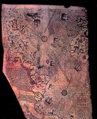 One of the strongest pieces of evidence for
this comes in the form of a map. The Piri-reis map has several interesting
features, in particular, the fact that it appears to show the correct
application of longitude and latitude, in addition to the fact that the map
centres on the 'Tropic of Capricorn' and the longitude of 'Alexandria',
suggesting knowledge of astronomy, geometry, and astrology at the same
time. We can reasonably
conclude from this that the makers of the map either originated from that region or
had a good knowledge of it. This evidence combined suggests a familiarity with the concept of a spherical globe, and the
mathematics necessary to translate compass points onto a two dimensional
representation. One of the strongest pieces of evidence for
this comes in the form of a map. The Piri-reis map has several interesting
features, in particular, the fact that it appears to show the correct
application of longitude and latitude, in addition to the fact that the map
centres on the 'Tropic of Capricorn' and the longitude of 'Alexandria',
suggesting knowledge of astronomy, geometry, and astrology at the same
time. We can reasonably
conclude from this that the makers of the map either originated from that region or
had a good knowledge of it. This evidence combined suggests a familiarity with the concept of a spherical globe, and the
mathematics necessary to translate compass points onto a two dimensional
representation.
The Piri-Reis map is actually a fragment of a larger world-map, composed from several
smaller maps, all of which were calculated to centre on Egypt. The
controversial suggestion that the continent of Antarctic is visible (seen in
entirety on other middle age maps), places the creation of the map no more recently than 4,000 B.C., as established by core-sampling
from the Ross-sea, which showed that the continent was obscured with snow and
ice after that date.
The implications of the Piri-Reis map are considerate. There is a clear
suggestion from the location and dimensions of Egyptian temples and sacred
sites that they were aware of the dimensions of the earth, and included both
longitude and latitude into the placement of their most important structures.
The Piri Reis Map: An Egyptian Legacy?. Although several uncertain claims have been
made concerning the Piri-reis map, there was one interesting result from
Hapgood's research which has a significant bearing on this subject.
The accuracy of the map in terms of longitude and latitude made it
possible to calculate the cartographic centre, which was... you guessed
it..
Egypt.
The centre of the map
-
Although only the left-third of the map now remains, the remaining 'Rose
des vents' on the map enabled Hapgood to project for the
cartographic centre (see below), which was calculated to fall in 'the
region of Syene', in Egypt, and following a series of more accurate
tests he determined that the centre of the map was situated on the
ancient Tropic of Cancer, and on the same Meridian as later Alexandria
(at 30� longitude).
The
longitude reading is easily explained in terms of the prehistory of the
Nile valley, but the latitude is far easier to explain in terms of
astronomy or geodesy.
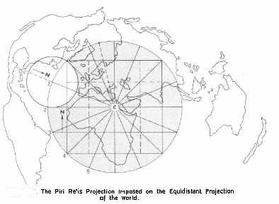
Centre of Piri-reis map - (24� 06� N, 30� 00�
E).
The suggestion that the latitude was chosen because of its
astronomical relevance is of interest as the latitude of the Tropics is
known to have changed over time. In fact, at the time of Eratosthenes
for example, the Tropic of Cancer was at 23� 45� N, and the region of Syene, or rather, Elephant island on the Nile, which is situated at 24�
06� N, would no longer have functioned as a marker of the suns vertical
rays in his time, and the only time it would have worked in the way
described would have been at around (3,000 BC). The latitude of 23�
30� has only been applicable in recent times which makes the fact that
it centered on the region of Syene very significant.
Syene is on the same longitude as modern day Alexandra
-
30� 00� E. They define the
western extremes of ancient Egypt.
 There have been several suggestions that geodetic
measurements were observed in Egypt before the Greeks, For example,
Strabo the
Geographer stated that �the science of land-measuring
originated along the Nile in Egypt' (Book XVII), from a necessity to record the boundaries of the nomes
(provinces) of the country, and it is suspected from the placement of
sacred Egyptian cities and shrines (as seen above) that a knowledge of the earth
as a
globe, its dimensions and a division into 360� existed in ancient
Egypt (as seen in the Piri-reis map - Eratosthenes later
divided the globe into 60
divisions of 6�). There have been several suggestions that geodetic
measurements were observed in Egypt before the Greeks, For example,
Strabo the
Geographer stated that �the science of land-measuring
originated along the Nile in Egypt' (Book XVII), from a necessity to record the boundaries of the nomes
(provinces) of the country, and it is suspected from the placement of
sacred Egyptian cities and shrines (as seen above) that a knowledge of the earth
as a
globe, its dimensions and a division into 360� existed in ancient
Egypt (as seen in the Piri-reis map - Eratosthenes later
divided the globe into 60
divisions of 6�).
In relation to this, the diameter of the circle formed by the
Rose-des-vents on the Piri-reis map was calculated to cover 69.5� of
the earth surface (approx 4% less than 72% (1/5th) - as
per the Eratosthenes error - which could be eliminated if the angle of
the ecliptic were extended to 24� 45�). So
that, while we are
comfortable in assuming that the maps of Eratosthenes and Ptolemy
provided all the necessary information for latter generations to pick up
on (as they did), eventually leading to the production of the Piri-reis
map and others, a deeper root has appeared, which points back to earlier
activity, and perhaps justifies Hapgood�s theory of the existence of an
�set of ancient knowledge' in the maps.
(More about the Piri-Reis Map)
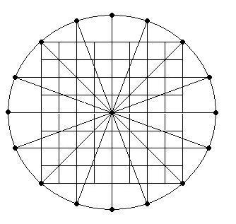
The 12-Wind system
We have seen that the centre of the Piri-reis map was in
the region of Syene, the south-westerly point of Egypt.
The geometry used in the map is - in effect, the
cartographer's fingerprint. It shows a division of 360� and uses a
system known as the 'twelve-wind' system, (based on an 8x8 grid).
It is perhaps not so strange that we find this very same geometry in the
ground-plan of Giza.
The meticulous
measuring of the Giza complex by Petrie, Smyth and others, has
illuminated the extent of the geometry at Giza,
but there is a simple geometry behind the Giza layout which returns us
again and again to 30 .which has in fact been associated with an 8x8
grid before as noted by John Michel (3),
who mentions
'Levi's magic squares' of which there was one for each planet,
and that each of the seven wonders of the ancient world represented a
planet, and that Giza represented Mercury 'the messenger', whose square
was an 8x8). While this may be a coincidence, it seems worth
mentioning.
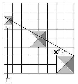 
It can be seen
that the 8 x 8 grid used for the layout of the Giza pyramids (above,
left) simultaneously reveals the 5:8 ratio between the corners of the
three pyramids (which are aligned to Heliopolis), otherwise known as the 'sacred mean', and
a symbolically relevant geometric figure. and including
sufficient geometry to create 12 equal divisions of 30�, as seen both
between pyramids and in the actual location of Giza (on the 30th
parallel).
It can
also be seen from the diagram (above, right), that the basis for the
Giza ground-plan mirrors Hapgood's method for determining the centre of
the Rose-de vent's on the Piri-reis map.
(More about
the Piri-Reis Map)
|