|
 Prehistoric Geodesy:
(Greek geōdaisiā : geō
- 'earth', daiesthai - 'to
divide')
Prehistoric Geodesy:
(Greek geōdaisiā : geō
- 'earth', daiesthai - 'to
divide')
 According to the
classical definition by Freidrich Robert Helmert (1880), 'Geodesy is
the science of the measurement and mapping of the Earth's surface'.
(4)
Geodesy, along with astronomy and
geography are among the oldest sciences dealing with the planet earth. According to the
classical definition by Freidrich Robert Helmert (1880), 'Geodesy is
the science of the measurement and mapping of the Earth's surface'.
(4)
Geodesy, along with astronomy and
geography are among the oldest sciences dealing with the planet earth.
The Science of
Geodesia is commonly attributed to the Greeks, namely Pythagoras (580-500
BC) and his school who were the first Greeks to propose a spherical earth,
which by the time of Aristotle (384-322 BC), was
a generally accepted concept and had been substantiated by
observation. However, the official founder of geodesy is Eratosthenes
of Alexandria (276-195 BC), who was the first person to approximately
deduced the earth's radius.
Eratosthenes realised
that at noon on
summer solstice the rays of the sun descended vertically into a well
in Syene (modern day Aswan). Whereas in Alexandria (approximately on
the same meridian as Syene), the sun's rays formed an angle which he
determined to be 1/50th of a complete circle (7� 12').
Of particular
interest is that these ancient and sacred Egyptian cities (along with
several others) had already been established long before Erastothenes.
There is now a growing school of thought behind the idea that they
were deliberately positioned according to an ancient set of geodetic
traditions.
In Guatemala, the Mayas recorded in their
sacred book, The 'Popul-Vuh', that the 'first men' possessed tremendous
knowledge: 'They were able to know all, and they examined the four points of
the arch of the sky and the round face of the Earth". (9)
The Evidence:
The most
significant evidence in support of this theory is the specific
placement of several of the most significant Egyptian monuments
themselves. The Nabta Playa complex,
a megalithic site composed of a stone circle and several outlying
menhirs, was built c. 4,500 - 4,000 BC on the path of the Tropic of
Cancer. Such an astronomically significant placement, combined with
the orientation and alignment of the megaliths themselves, makes for a
compelling association between the placement of Egyptian structures
and astronomy at this time.
Several of the most significant complexes in Egypt share a geometric
relationship with each other.
The placement of the following sites reveals a geometric pattern based
on earthly measurements:
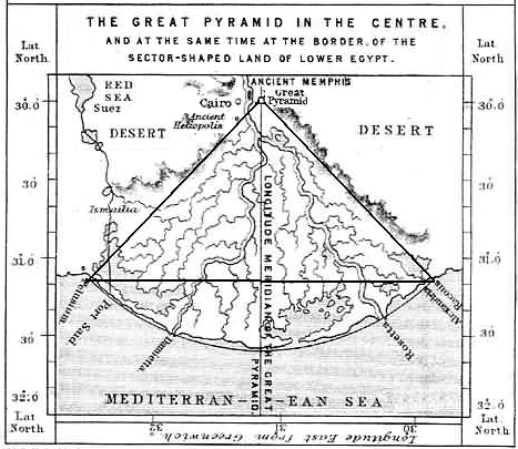
Giza :
Capital of Early Dynastic Lower Egypt.
(29� 59' N).
Giza to
the Equator = 1/12th the circumference of the earth. (360�/12 = 30� 00�).
The
perimeter of the Great pyramid is such that it occupies exactly 1/2 of a
minute of latitude at the equator.
'Whoever built the great pyramid knew, as the legends accurately report, how
to make excellent charts of the stars with which to correctly calculate
longitude, draw maps of the globe, and so to travel at will across its
continents and oceans'.
(1)
( More about the Geometry
of Giza).
|
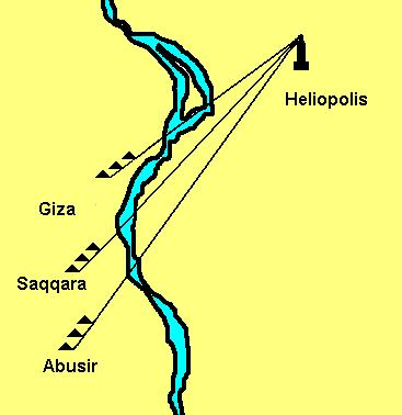
Heliopolis:
('City of the Sun').
Although the Giza complex is generally referred to as the
Geodetic centre of Egypt, it shares a particular design feature with
the other (3rd-6th dynasty) pyramid complexes in the region.
The corners of the Giza pyramids and most of the other 4th - 6th
dynasty pyramids are aligned towards
Heliopolis, which also sits close to the 30th parallel (30� 06'
00" N).
For this reason, perhaps Heliopolis
should be considered the geodetic centre (or geodetic origin) of Egypt and not Giza.
The pyramids built at these sites, specifically those
built between the
3rd-6th dynasties, have their corners aligned in the direction of
Heliopolis (named 'On' in the Bible), while those built before or after,
although still showing a
preference for alignments, no longer do so towards Heliopolis. For this reason, and
because of its closer proximity to the 30th parallel, Heliopolis might
well be
considered the true geodetic centre of ancient Egypt. Sadly, the site has been reduced today
to a solitary obelisk.
(More about the
alignment of Egyptian pyramids)
The significance of Heliopolis is clear from historical
references and the alignment of the large 'Memphite' pyramids. It seems
relevant therefore, to find that it shares several
similarities including close
geometric and geodetic connections with other important ancient and
sacred sites, of particular interest is the association with Baalbek
(Also called Heliopolis) in Lebanon, which lies almost exactly
4�
North and 5� East of Giza.
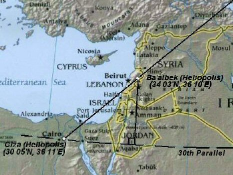
Heliopolis:
(30� 06'
N, 31� 19' E) - Baalbek:(34� 03' N,
36� 10' E).
|
Other Significant Sites:
Amarna:
Temporary Capital of Middle Dynastic Egypt. (27�
38� N)
Amarna to Equator = 1/13th of
the circumference of the earth. (360�/13 = 27� 41�).
Significance:
In 1350 BC Akhenaton unexplainably moved his capital
from
Luxor
(Thebes) to Amarna, which he ordered to be built in an otherwise desolate
region.
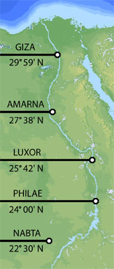 Thebes:
(Luxor)
Capital of Early Dynastic Upper
Egypt.
(25�
42� N) Thebes:
(Luxor)
Capital of Early Dynastic Upper
Egypt.
(25�
42� N)
Thebes
to the Equator = 1/14th of circumference of the earth.
(360�/14 = 25� 42�).
Significance:
Thebes was considered the spiritual centre of 'upper'
Egypt, and was equalled in importance only Giza/Heliopolis in the North.
It is related to other sites both through geometry and geodesy,
as supported by myth and the historical memoirs of Herodotus.
Philae: �The
first cataract�. (24� 00� N).
�First cataract� to the Equator =
1/15th of the circumference of Earth. (360�/15 = 24� 00�)
Significance:
The official southern border of ancient Egypt. The distance between the
southern border and Heliopolis (on the and northern border) was exactly
6� of Longitude.
Nabta Playa: Megalithic stone circle/complex (22� 30� N)
Nabta to the Equator = 1/16th
of the circumference of the Earth. (360�/16 = 22� 30�).
Significance: The only megalithic remains of its kind in Egypt.
(c. 4,000 BC),
Built on the Tropic of Cancer.
Giza (Heliopolis) and the 30th Parallel.
The specific placement of the Giza
complex on the 30th parallel has long led people to suspect
that it was constructed at that location according to deliberate
geodetic placement. Piazzi Smyth suggested that the Giza complex
identified an ancient 'meridian' as long ago as 1864. The
latitude of Giza at 30� N, has been shown to have a geometric
relationship with other sacred
Egyptian complexes (see above), which in itself is suggestive of a deliberate geometric
system of placement. However, the latitude of 30� has its own
geometric significance, representing 1/3rd of the way from equator to
pole and a 1/12th division of the circumference of a circle. This
division can be seen in both the measure of time and space (there are 12
solar months in the year, 24 hours in each day, and 12 astrological
signs in the heavens).
When viewed on a two-dimensional model, the 30th parallel has the
unique property of denoting both a third of the circumference of the
northern hemisphere, and half the distance from the Equator to the North
Pole.
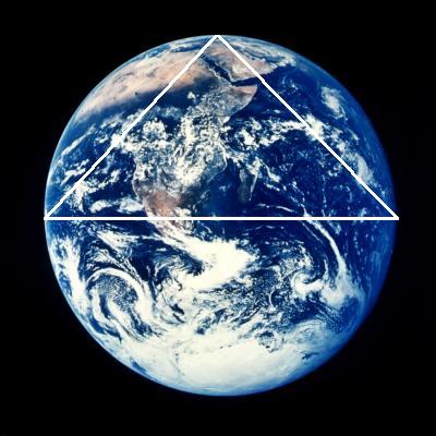
The exterior angle of the Great pyramid is replicated in the
angle of the Nile Delta, and is also exactly 1/1000th scale with
Alexandria and Behdet (above, left). The Great Pyramid of Giza is
also a 43,200 scale representation of the outline of the northern
hemisphere of the earth (Right). This number is also double the number of years
in the 'Precessionary' cycle, during which the heavens complete an
apparent full rotation in the night sky.
(More about Precession)
The preference for the placement of other ancient sacred sites along the
30th parallel, (all of which lie to the east of Giza, and none to the
west) is clear. A tradition which can be clearly traced back to at least
3,000 BC.
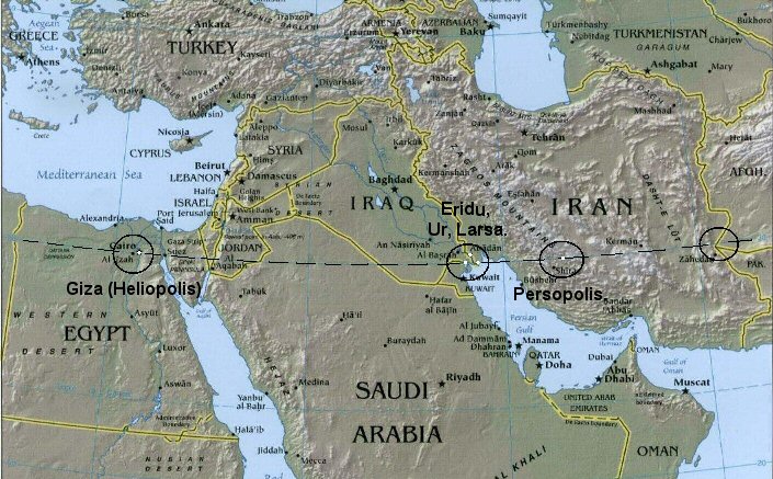
Persopolis was placed 21� 36'
(3 x 7� 12') East of Giza, while Lhasa in Tibet, lies exactly 30�
East.
The
location of the Persopolis complex
(30� 00' N, 52� 50' E)
is curious for several reasons, not least the complete lack of housing
in a citadel of temples and shrines in a place essentially built in the
middle of nowhere, suggesting
the site functioned in a 'sacred' capacity. Hancock's suggestion
that Persopolis was deliberately sited 7� 12' from
Giza,
offers a reasonable explanation for the reason for the location of Persopolis, which was
until then considered a
mystery, as the city seems to have been built inexplicably far from any other known contemporary ancient cities or
urban centres.
(More about Persopolis)
The placement of so many important Egyptian
sites on geometrically related latitudes is convincing in itself, but
there is also a growing amount of evidence that the ancient Egyptian
(Giza-Heliopolis) meridian was observed and used as a bearing point for
the location of many other important and sacred sites far beyond
Egyptian borders.
(More
about Prehistoric Egyptian Geodesy) |
| Eleusis Alaise.: The Eleusian Mysteries |
The same geodetic footprint
(with a division of the globe into 360� equal parts), can also be
seen in other regions of prehistoric Europe, in particular in France. It is a curious
fact that the distance between the French Meridian running through
Paris, is separated from the Greenwich meridian running through London
by the same distance in degrees as the eastern and western borders of
ancient Egypt (1�
09�).
In the early 20th cent. a French
detective named Xavier Guichard began a personal investigation the roots
of place names in France. His research led him to conclude that there
had once existed a network of alignments extending throughout France
(and other areas of Europe), which were connected by locations with the
root-name 'Alaise', and through longitude and latitude. He
concluded that he had touched upon the Eluesian mysteries of
ancient Greece. His work was entirely independent of Alfred Watkins work
on 'Ley- lines'.
Alaise - (47� 00' N. 5� 58' E) Eleusis - (38� 00� N, 18� 00� E)
The two sites are
separated by 9� Latitude and 12� Longitude.
Of particular relevance is the fact
that Guichard's research uncovered the fact that the Aleusian sites were
separated by units of degrees of longitude and latitude, a notion that
suggests an understanding of higher geometry and several other sciences.
Guichard's research has traditionally been scorned by mainstream
historians, but independent research confirms his data ( View
Data), and therefore much of his original theory.
(More
about Xavier Guichard)
(Original
facsimile of Eleusis Alesia)
|
The 'Oracle Octave':
The Geodetic Placement of
Oracle Centres. |
The suggestion that the Eleusian
mysteries were in some way related to a working knowledge of geodesy
was also made by Livvio Stecchini, who
suggested that certain ancient oracle centres
were placed according to geodetic principles at which 'Omphalus' or 'Navel
stones' were placed.
This idea is supported by the historical narratives of
Herodotus, who wrote that the oracle centre of Amon in Libya was founded by
flying doves from Thebes, which was long considered the geodetic centre of
ancient Egypt, and is located 2/7ths of the distance from the equator to the
North pole (and at which an Omphalus was later discovered). Herodotus also
wrote that the oracle centre at
Dodona was
said to have been founded by Egyptian priestesses from
Thebes and that doves
flew between the two sites.
A
milestone of literature on the subject of the geodetic placement
of oracle centres already exists, written by Livio Stecchini
(22),
who concluded that several ancient oracle centres in the
Mediterranean and Middle-east, were deliberately placed along
specific latitudes and separated by units of 1�, which he
suggested composed an 'oracle octave', along which the
seven major centres were placed, each devoted to one of the
seven known planets and symbolised by different sacred trees
(for more on this subject refer to the 'Tree alphabet' in
R. Grave's book, 'The White Goddess'). Underlying this
geodetic placement, he believed was a set of knowledge that that
formed the basis of the 'Eleusian
mysteries'.
Stecchini said this
about the subject:-
�The Temple of Ammon at Thebes at latitude 25� 43� N was considered, and
is, located at 2/7 of the distance between the Equator and the pole.
Ancient geographers divided the space between the Equator and the Pole
into 7 zones. Egyptologists have vainly tried to explain why the Greeks
gave the name of Thebai to the city called Wast by the Egyptians; the
explanation is provided by the Hebrew word thibbun meaning �navel�. From
the Bible (Jud. 9:37) we learn that �a navel of the earth� was located at
Mt. Gerizim where there was originally the sacred center of the Hebrews
before it was moved to Jerusalem; the Samaritans never accepted such a
shift, and geographically they were right, since the claim of Jerusalem to
be the navel of the earth was not correct. The eastern gate of the
Second
Temple, where the standards of length were located,
was called Gate of
Susa, but
Susa was located at the latitude of
Mt.
Gerizim which is 32� 11� N. The sanctuary of
Mt.
Gerizim was located at a latitude that is 2� sevenths
from the Equator. Egyptian benchmarks had the shape of the �navel� found
at the
Temple of
Delphoi in
Greece. These �navels� had the shape of a hemisphere
with the meridians and parallels marked upon them; at times they are half
a sphere and at times they are elongated at the Pole. The sanctuary of
Delphoi was considered a �navel of the earth,� as being located at 3/7 of
the distance from the Equator to the Pole. This would correspond to a
latitude 38� 34� N; the Temple of Delphoi is actually located at a
latitude 38� 29� N, � which makes it 6� to the North of one of two
Egyptian anchor points, the original apex of the Nile Delta at latitude
30� 05� N on the axis of Egypt which is 31� 13� E. Susa was computed as
being 17� to the East of this point; it is at latitude 48� 15� E. When the
Assyrians established their religious capital at
Nimrud in 875 B.C. they chose a point that was 6� to
the North and 12� to the East of this Egyptian anchor point.
(22).
Stecchini's theory
was later included as a part of R. Temples book 'The Sirius mystery',
(22) in which he suggested that the distribution of oracle centres embodied an
ancient knowledge which had been stored in myth and tradition.
Significantly, he states that the pre-dynastic capital of Egypt, Behdet 'existed
before 3,200 BC', and was replaced by the city Canopus, (The same
name as the star that represents the 'rudder' of the constellation Argo).
He suggested that this was the key to the connection between the two
mythological narratives of the �Ark� of the Hebrews and the �Argo�
of the Argonauts, which he believed, revealed evidence of a prehistoric
system which included an understanding of astronomy mathematics and
geo-metry (as in the sense of measuring the earth).
(Click here for more about the Oracle centres)
|
Having seen that there is a growing weight of evidence to
suggest that the Early dynastic Egyptians used longitude and latitude in
the placement of their sacred sites and cities, and that the Piri-reis
map places Egypt at its centre. The current division of 360 for the
globe, creates by definition, a modern world-grid.
The specific
separation between Giza and other sacred sites offers evidence of a
division of 360� even at this early time. Sumerian mathematics supports
the idea of a base 6 division of both time and space.
Base-6 and the megaliths.
The Sumerians were the first
people known to have divided both space and time by units of six
with the 'Hexi-decimal' system of counting: 6 x 10 x 6 x 10 etc...
(6 x 10 x 6 = 360). The modern division of the year into 12
months, the 24 hours of each day, the division of hours into 60
minutes and 60 seconds, and the divisions of the circle/sphere by
360 degrees, each composed of 60 minutes and 60 seconds of an arc,
are all remnants of this Sumerian development. This same division by
units of six has been observed at several prominent British
megaliths.
Aubrey Burl said of it:
'From Brodgar, where there
was once 60 stones, to the Stripple stones with a probable thirty,
the builders may have counted in multiples of six. Stennes had
twelve. The inner and outer rings at Balfarg have been computed at
twenty-four and twelve respectively. Twenty-four has been
suggested for Cairnpappel, thirty-six for
Arbor Low,
and the same number for the devils quoits'. (3)
Prof. Alexander Thom radically suggested that geometry was used in the
design of certain prehistoric
sites. He surveyed hundreds of European megaliths and concluded that
fundamental mathematic principles, based upon a common unit of measurement
(which he called the
megalithic yard),
had been applied in the
design of certain sites. As the megalithic tradition in Europe can be traced
back to at least 4,000 BC, if not earlier still, his work is still not
accepted by most archaeologists, although such a strong presence of
geometry should not be ignored, as is clearly suggests that the design of
many sacred sites seems to have been based on a sophisticated
philosophy of sacred science such as was taught centuries later by the
Pythagorean school.
As
Professor Thom observes in his book Megalithic Sites in Britain
(1967):
�It
is remarkable that one thousand years before the earliest mathematicians
of classical Greece, people in these islands not only had a practical
knowledge of geometry and were capable of setting out elaborate
geometrical designs but could also set out ellipses based on the
Pythagorean triangles.�
The two most prominent stone-circles on
the Orkney islands, Stennes and Brodgar; the 'temples of the Sun
and Moon', originally had 12 and 60 stones respectively. The two
circles are physically linked by a man-made causeway and are
intervisible, although several astronomical orientations and
alignments have been suggested, the Maes-Howe passage-mound
offers the most conclusive proof of an astronomical association
between the megalithic builders and astronomy. It is noticeable that
the site is also on the 59th latitude.
Brodgar:
(59� 0' 5" N. 3� 13' 51" W)
Note that Giza
is located at 30� 05� N.
31� 11� E, almost exactly 29� south and 34�
east of the Orkneys complex.
(More about the Orkney's complex)
Other examples of
Base-6 mathematics at European megaliths.
Carnac: The great alignments at
Carnac were originally composed of 12 rows of stones.
Stonehenge: 30 huge sarsen
stones form the main circle at Stonehenge.
Prehistoric British
Geodesy
The Great pyramid and Silbury hill share a
particular geometric feature in an intimate fashion. The Great pyramid has an
exterior angle of 51�
51', which is the same as the latitude of Silbury hill and the result of 90�/7
(x4). Silbury hill has an exterior angle of 30�,
the same as the latitude of the Giza complex.
The Avebury complex, the largest megalithic standing
stone and Henge-Circle in England is situated exactly a quarter of a degree from
Stonehenge on the Salisbury plain. Avebury is also located 1/100 of the
planetary circumference from two major archaeological complexes in
Ireland, Newgrange and Tara. (3.602�).
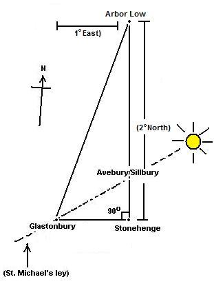
Avebury,
Glastonbury and Stonehenge are all positioned in such a way so that
they are positioned in relation to other important British
megalithic sites be units of single degrees. (Based on a division of
the globe by 360�). The alignment from Stonehenge to Avebury
continues North until it reaches Arbor Low, reputed to be one of the
most important 'Ley' centres in UK. In addition, Arbor Low is
geodetically separated from other important sites such as
Brynn celli Ddu,
Callanish, and even Mont St.
Michel in France.
The latitude of 53� 10' is the same
angle as that produced by the 3:4:5 Pythagorean Triangle. It is also
coincidentally, the same as the exterior angle of
Khafre's Pyramid at Giza.
It was first observed
by Sir N. Lockyer that Stonehenge was connected to other ancient sites
through geometry. Perhaps significantly, the geometry he determined
created an equilateral triangle with internal angles of 60�. We can also
see that Stonehenge lies exactly 1/4 of a degree of latitude from
Avebury, both important centres of activity in prehistoric England.
Stonehenge is suggested to be connected to other important sites through
geometry, in particular, it is worth making mention of the 'Great
Great Decagon', as proposed by J. Michell,
which involves angles between sites of 36� and 72�. In addition, Avebury
and Glastonbury are aligned with Stonehenge at 90� of each other. All of
these geometric alignments are accurate to within 1 part in a thousand
(1/1000th accuracy), far higher than the scientific requirement (95%) for
significance.
There are several other
cases of geometric connections between megaliths in Britain, but importantly, these
geometric connections reveal an underlying preference for locating the
most important sites according to geodetic principles, including the
apparent separation of sites in units of degrees based on a division of
360�.
(Other Geometric Alignments)
(Prehistoric
Egyptian Geodesy) (Prehistoric British
Geodesy) (The
World-Grid) |
|