|
 Xavier Guichard:
(Author of 'Eleusis Alesia')
Xavier Guichard:
(Author of 'Eleusis Alesia')
Xavier Guichard (1870 - 1947). Born in Pesmes, Haute Sa�ne,
France. Became the director of Police in Paris.
Vice-President of the
Soci�t� pr�historique fran�aise, in 1936 he published the now famous -
"Eleuse Alaise: Enqu�te sur les origines de la civilisation
europ�enne" [Investigation of the origins of European Civilization]
One of Guichard's curious claims to fame was that he
appeared as the primary detective in the novels of Georges Simenon.
T he fascinating work of the famous French detective Xavier
Guichard remains relatively unnoticed regardless of (or possibly due to),
his astonishing conclusions regarding the level of prehistoric geometric
abilities.
(Click here for
map of Alaise)
(Click here to view a full copy
of Eleusis Alesia)
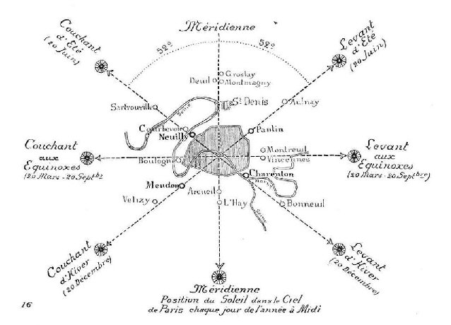
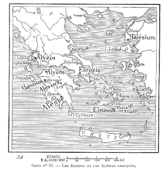
Guichard claimed to have discovered two prehistoric 'rose des
vents' covering France and extending into other parts of Europe, based
on 24 landscape alignments (corridors of incidence), all orientated so
as to pass through a common centre-point (called Alaise). Secondly, he
identified three European 'root' names;
Burgos,
Antium, and Alaise, which he believed (similar to his UK
counterpart, Alfred Watkins) had different meanings associated with ancient
mineral sources and trade, but more controversially, that the 'Alesian'
locations had been placed according to their longitude and latitude.
Alaise
was the hub of an archaic, yet very precisely surveyed, radial system
of 24 ley lines which emanated from Alaise, in all directions, one ley
line every 15 degrees of 360, and along these 'ley-lines' were also
located ancient settlements named with etymological affinity to
the town-name of the ley line system�s hub, Alaise...
Guichard also claimed to have found evidence of a separate
'solstice rose des vents' at Alesia, based on solar observations,
creating a valuable connection between prehistoric geometry and
astronomy, (and from which it may still be possible to date such a
formation). He concluded that he had uncovered the vestiges of what had
been called the 'Eleusian mysteries' by the Greeks. It is perhaps just a
coincidence that both Stecchini and Guichard (supported by Manias),
independently concluded that the true secret of the mysteries involved
the application of longitude in relation to the placement of ancient and
sacred sites. (More
about the Eleusian mysteries below).
Referring to several old cities in his
native Franch, Guichard said:
"These cities were established in very
ancient times according to immutable astronomical lines, determined
first in the sky, then transferred to the earth at regular intervals,
each equal to a 360th part of the globe."
As well as the astronomical 'Rose-des-Vents' Guichard
realised that his research had, in his own words;
'revealed the existence of geodesic lines that converge on the 'alesia'
of Alaise, and of other alignments that appear on modern maps...These
alignments belong to a geodetic system completely different from those
that make up the line that converge into two 'rose des vents'. And it is
only through satisfying their existence out of necessity that the lines
which cross through Alaise were analyzed in the first place'.
He continues...
'These new lines are those that run parallel and
perpendicular to the Equator, their trace reproduced therefore, on a map
as latitudes and longitudes...The works of ancient authors attest that,
from the oldest antiquity, geography had been practiced ��
Strange as it may seem now, supporting evidence for
Guichard's theory of France holding the key to the 'mysteries' can be
found in the official centre of the French capital Paris, which was
suggested (by J. Michell) to have been named par-Isis, relating to an ancient
temple of Isis (at Versaille), and where the 'Champs-Elys�es' or
'Elysian-fields' can be seen to point directly in line with the
midsummer sunrise at 52� (left). We will see later that this particular
orientation is shared by other French sites such as at Versailles
cathedral and Mont St. Michel, also both orientated along the azimuth of
the mid-summer sun, but at an angle of 26�, the angle of polar passage
in the Great pyramid. The relevance of these particular figures is best understood in relation to precession of the equinox.
(Precession of the Equinox)
The astronomical significance of the placement of Paris
('Par-Isis').
It is possible to see that the French Meridian, which passes both the
northerly and southerly points of France, also passes through Paris at
the correct latitude for the summer and winter solstice sunrises and
sunsets to occur at 52 �
off True North/South (A phenomena which is captured along the 'Champs de
Lysee' (Tr. 'Elysian Fields'), which is orientated along the path
of the rising summer solstice sun and the setting winter solstice sun.
The Paris Meridian sits exactly
1� 09�
east of the Greenwich Meridian
(the same distance of separation as between the official eastern and
western borders of ancient Egypt).
(More about Egyptian Geodesy)
|
Independent
Confirmation of Guichard's Results.
An
Independent study of Guichard's original data confirms the accuracy of his report. It is noticeable however that that
there is a fundamental difference between Stecchini's Oracle centres and
Guichard's Alaise locations, as while Guichard's 'Alaisian' sites are all
situated on exact lines of latitude and are therefore all separated by
multiples of complete degrees, while the oracle centres still being
separated by exact degrees, are situated at latitudes of X� (+30'),
(still based on a division of 360�). It is important to recognize that
these alignments substantially pre-date the Greeks and are associated
with mineral resources, mostly from mines or 'man-made well's',
invariably located on hills
overlooking rivers.
Results:
-
Approximately 75% of Guichard's
original locations were determined. (25% could not be found in the
preliminary search).
-
Every one of the determined locations
proved to be accurate (well within the recognised 95% accuracy).
-
Every one of the determined locations
was positioned on a whole unit of degrees, either longitude or latitude.
(within 95%, or 3' ), which proves that the system was based on a 360�
division of the globe, not a 366� division as recently suggested..
-
I was unable to find any significant
Alaisian sites un-mentioned by Guichard.
-
There is a clear preponderance of
rivers next to Alaisian locations.
While most of Guichards locations are
verifiable with any decent map, there are several examples of slight
name changes since his time c. 1911- 1930. (For
example 'Llusa' in Spain is now 'Lluca', 'Alex' in
France is now 'Aleix', and 'Leysele' in Belgium is now 'Leisele').
It is therefore possible that some of the missing locations may have
been changed beyond recognition, and this might account for some of the
missing data.
Guichard reasoned that the origin of the
Root-name Alaise, had its roots in the ice-age, because the same pattern
didn't extend to prehistoric Britain. However, it seems equally likely
that the system was incorporated after Britain became isolated
from mainland Europe, anytime after c. 5,000 BC, as there seems little
necessity for charting a salt-path across sea water...
(Click
here for full results)
|
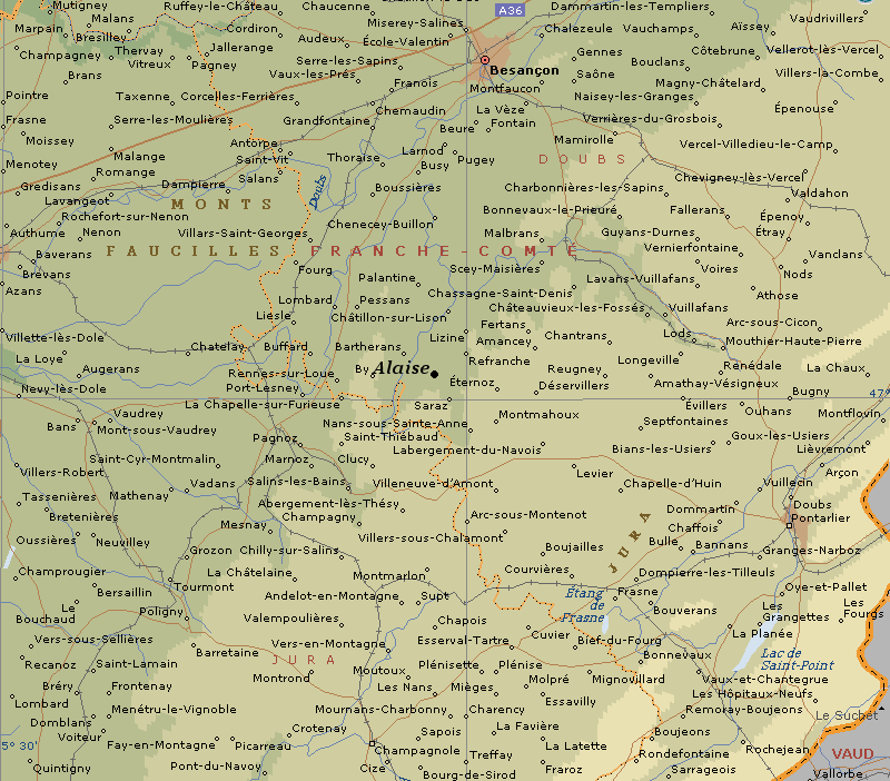
Where is Alaise..?
Curiously enough, the architect Delacroix in 1850, suggested that the
identity of Al�sia and Alaise were in doubt as noted in his speech of
acceptance at the Academy of Besan�on in 1864.
'Al�sia, l'antique m�tropole de toutes les Gaules, le
lieu de la supreme lutte contre la domination de Rome, fut selon
l'historien Florus, Br�lee
et ras�e. "...
Alesia, the ancient metropolis of all the
Gauls, the place of the supreme struggle against the domination of Rome,
was according to the historian Florus, burned and razed.
'La Volent�
de Julius C�sar
fut que le silence r�gn�t
d�sormais
par-dessus la cit�
sainte de ces Galois auxels, selon Tacite et contrairement a la fable
imagin�e
par le complaisant Tite-Live, le S�enat
reprochait d'avoir d�truit
non seulement Rome et sa citadelle mais encore son Capitole'.
The will of Julius Ceasar was the silence
that now reigned over the holy city of the Gauls, as suggested by
Tacitus and unlike the fable dreamed up by the complacent Livy, the
senate accused of destroying not only Rome and its citadel but also its
capital.
'Mais revenons � la question pos�e par M.
Gabriel Meunier'.
But back to the question posed by M.
Gabriel Meunier.
'Apr�s les r�cits de Dion Cassius,
Plutarch, les Travaux Allemandes et Italiens, ant�rieurs au XVIII
si�cle, selon lesquels Al�sia ne peut-etre qu'en Franche-Comt�, le
trajet des arm�es Romaine et Gauloise a fait l'objet de reserches aussi
pr�cises que possible.'
After the stories of Dion Cassius,
Plutarch, the Germanic and Italian works, prior to the eighteenth
century, it was realised that Alesia could not be in Franche-Comte, as
the route of Roman and Gallic armies had been researched as accurately
as possible.
Not only does he call Alesia 'The ancient Metropolis
of ALL the Gaul's', but also of interest is the statement later in
the text concerning the disputed location of the
Battle of Alesia in which it is noted that:.. 'The
similarities between Alais and Alise are remarkable, many, even
disturbing: location, proximity to a river, shaped hills.. dedicated to
Rhea'... supporting Guichard's suggestion that the Alaisian sites
had contemporary landscape features.
(3)
(Click here for
map with location)
The Cassini Documents.
The Casssini documents are a collection of papers
concerning the work of Jean-Domenica Cassini (1625-1712) who was charged
by King Lois XVI to establish a French Meridian. His work began a
dynastic saga of Cassini Astronomer Royales, and it was from a
significant part of the Cassini collection � 'The Cassini Documents' �
which are preserved in the region of Perpignan, are the ones that the Paris prefect
Xavier Guichard used to write, in 1936, Eleusis Alesia; as he notes on
page 119, he reuses the �Cassini layout� for sites close to the
Observatory, like the passage of the Meridian through Groslay, Montmagny,
Deuil, St Denis, Arcueil and Hay. All are sites on which Cassini
worked'�
(2)
The construction of the French meridian immediately
brings out certain intriguing details, as not only does it run through
the northernmost part of France in Dunkirk, pass through Paris, and
through the last town before the Spanish border, 'Prats-de-Mollo';
It also sits exactly 1�
09�
east of the Greenwich meridian in England, which is the same as the
distance between the Eastern and Western borders of ancient Egypt.
Alaisian Longitudinal lines.
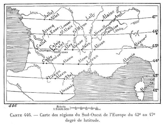
Alaisian Latitudinal lines.
|
The 'Ley's' of Britain.
At almost exactly the same time as Guichard was researching
the �Alaise� alignments in
France,
Alfred Watkins was independently in the process of uncovering the
network of ley-lines that covers the UK. Watkins originally named
his alignments 'ley' lines because of the frequency of
place-names containing 'ley' (A 'ley' or 'lea' is variously
translated as a clearing or glade). The similarities in place-names
is of interest as there is no suggestion that the two men had any idea
of each others existence, and both men provide good reasons for naming
their findings as they did. This reinforces the suggestion by Guichard
that a system of placement once existed that stretched across
Europe (and one which shows evidence of a common unit of
measurement - as later suggested by Prof. A. Thom).
In the early 1920's,
Alfred Watkins first became
aware of the prehistoric alignment of ancient sites covering the English
landscape. He concluded that a feature of the old alignments was that certain
names appeared with a high frequency along their routes. Names with Red, White
and Black are common; so are Cold or Cole, Dod, Merry and Ley.
(The last as we know, he used to name the lines, although it has been noted
that 'ley' is Saxony for 'fire'). He suggested that ancient travellers
navigated using a combination of natural and man-made markers. Certain lines
were known by those that most frequented them so that 'White' names were
used by the salt traders; 'Red' lines were used by potters, 'Black'
was linked to Iron, 'Knap' with flint chippings, and 'Tin' with
flint flakes. He suggested that place names including the word 'Tot', 'Dod" or
'Toot' would have been acceptable sighting points so that the 'Dodman', a
country name for the snail, was a surveyor, the man who 'planned' the leys with
two measuring sticks similar to a snail's horns (or the 'Longman of Willington')
(It is noted that the Germans have similar names such as 'Dood' or "Dud',
which mean 'Dead'). Watkins maintained that leys ran between initial
'sighting posts'. Many of the 'mark stones', and 'ancient tracks' he refers to
have since disappeared, a situation which is considerably unhelpful to serious
research. Similarly to Guichard (above), Watkins believed that the lines were associated with former
'Trade routes' for important commodities such as water and salt. He found
confirmation in this through 'name-associated' leys.
Even today the Bedouins of North Africa use the
line system marked out by standing stones and cairns to help them traverse the
deserts. A letter to the
Observer (5 Jan 1930), notes similarities with Watkins theories and the local
natives of Ceylon, who had to travel long distances to the salt pans. The tracks
were always straight through the forest, were sighted on some distant hill,
(called 'salt-hill'), and that the way was marked at intervals by large stones
(called 'salt-stones'), similar to those in Britain. On the other hand, should
the leys be ancient tracks then it should be possible to see one point from
another. Also it is noted that there are many ancient 'tracks' across Britain,
such as the Ridgeway, and none of them are dead straight.
Both the French and English Ley's have a prehistoric precedence, with
roots in the Neolithic period.
(More about Ley-lines)
|
The Eleusian/'Aleisian' Mysteries.
|
Xavier Guichard concluded that the Alaisian phenomena had its
origins in the same traditions that became known as the 'Eleusian
Mysteries', later adopted by the Greeks. It is perhaps significant
that the two sites are separated by exact degrees (based on a
division of 360�).
Alaise - (47� 00'
N. 5� 58' E)
Eleusis - (38� 00� N, 18� 00� E)
The two sites are separated by 9� Latitude and 6� Longitude
conforming to the
idea of an underlying geometry between prominent prehistoric
locations.
(More about Prehistoric Greek geometry)
Livvio
Stecchini suggested that certain ancient oracle centres
were placed according to geodetic principles at which 'Omphalus' or 'Navel
stones' were placed.
This idea is supported by the historical narratives of
Herodotus, who wrote that the oracle centre of Amon in Libya was founded by
flying doves from Thebes, which was long considered the geodetic centre of
ancient Egypt, and is located 2/7ths of the distance from the equator to the
North pole (and at which an Omphalus was later discovered). Herodotus also
wrote that the oracle centre at
Dodona was
said to have been founded by Egyptian priestesses from
Thebes and that doves
flew between the two sites.
(More about Geodesy and the 'World Grid')
A
milestone of literature on the subject of the geodetic placement
of oracle centres already exists, written by Livio Stecchini
(22),
who concluded that several ancient oracle centres in the
Mediterranean and Middle-east, were deliberately placed along
specific latitudes and separated by units of 1�, which he
suggested composed an 'oracle octave', along which the
seven major centres were placed, each devoted to one of the
seven known planets and symbolised by different sacred trees
(for more on this subject refer to the 'Tree alphabet' in
R. Grave's book, 'The White Goddess'). Underlying this
geodetic placement, he believed was a set of knowledge that that
formed the basis of the 'Eleusian
mysteries'. Much of the following work should be credited to
Stecchini.
(More on the Oracle centres) |
As well as the
traditional association between Oracle centres
the Eleusian mysteries, it is perhaps curious that the centre of the Eleusian mysteries
themselves - Eleusis, appears to have been geodetically located,
in accordance with the same system of 360� as seen in Egypt, the Middle east and
Europe. In the Greek myth we see that Demeter makes an apparently
random stop at Eleusis, and are given no further clues to explain
her decision. However, it is particularly noteworthy in relation to
this that Santillana
(6), records Eleusis as having had a
well-spring in it covered by a navel-stone, as suggested by Cornford, who says that �one of these phreata (=wells) in
Eleusis was closed at its mouth by the agelastos petra,�
i.e. the laughter-less rock; and that Demeter was agelastos
because of the loss of Persophone. He adds that the place-name was
understood by the Greeks as �Advent�, a word used in the New
Testament in reference to the �advent of Christ�. The same
theme as seen to be repeated in the mythology of
Mecca and other earth-navels.
(Click here to view a full copy
of Eleusis Alesia)
(Geometric
Alignments)
(Geodesy
Homepage)
(The
World-Grid)
(Ley-lines)
(Other French sites)
|