|
 Prehistoric British
Geodesy:
Prehistoric British
Geodesy:
It has long been suspected that a form of geodesy was used for
determining the locations of some of the most prominent prehistoric British
Monuments. One of the major problems with accepting this fact is that
geodesy involves an operational understanding of geometry, astronomy and both longitude and
latitude, the latter having only relatively recently rediscovered
(following the creation of an accurate ships-clock in 1540).
So how are we to explain the separation of the
largest and most significant megalithic sites in Britain by units of
exact degrees (remembering that a degree of latitude is different from a degree of
longitude). Is it simply a set of coincidences, or can it be that our
prehistoric ancestors had the capacity to determine the longitude and
latitude of their sacred monuments, placing them into a geodetic
relationship with each other.
All of the information on this page can be confirmed with
ordinance survey maps or through digital mediums such as Google-Earth
etc.
|
The Geodetic Placement of
British Megaliths: |
Many of the most
largest megalithic monuments in Britain were built with a geodetic
relationship to each other.
Most of the
remaining significant megalithic sites in Britain such as
Glastonbury, Stonehenge, Avebury, Silbury Hill, Arbor Low, The Ring of
Brodgar, Callanish, Tara Hill and the Boyne Valley passage-mounds in
Ireland, are all separated from each other by units of degrees (based
on a 360� division of the globe). This relatively startling
information is supported by other significant geodetic and geometric
connections between the prehistoric British/European complexes. (See table
below for
confirmation).
360 Vs 366 Geometry.
In addition to an
apparent placement of prehistoric sites according to a division of
the globe by 360�, Christopher Knight and Alan Butler have suggested
that there may also be evidence of use of a 366�
division of the globe in prehistoric times. How this accords with
the 360�
placement is yet to be understood but their evidence shows that both
Thornborough and Stonehenge share similar dimensions which appear to
be based on circumferences of units of exactly 366�
megalithic yards. The same dimensions could also be found in the now
completely destroyed Dorchester-on-Thames Henge which lies on the
St. Michael's Ley.
According to their
system, the Thornborough Henges,
which all have circumferences of 732 megalithic yards (366 x 2), are
also located at 1/10th the planets circumference from the pole.
It is also worth noting that the distance between the centres of the
three Henges is 366 MR and 360 MR
(4)
The Association
between Astronomy and Geodesy: There is a close, almost symbiotic
relationship between astronomy and the megaliths which extends beyond
the orientation and alignment towards significant celestial events, as
some appear to have been located on latitudes that deliberately accord
with those events. Stonehenge for example, was placed at the exact
latitude such that the azimuths of the moon and the sun were at right
angles to each other during the extreme settings of their cycles. The
same latitude is also directly under the extreme northerly setting of
the moon in its 18.6 year cycle. In addition, the Orkneys complex was
located such that the exact same phase of the moons cycle, it would
appear to 'glide' along the horizon at the latitude of the Ring of
Brodgar, Maes Howe and the Stones of Stenness.
The three arguably
most important southern English sites ( Glastonbury, Avebury and
Stonehenge), form a huge right-angled triangle across the English
landscape. All of the sites have secondary relationships with each
other, and all are separated by units of degree.
The solar geometry of prehistoric England.
The Salisbury Meridian
It can be seen that Stonehenge
sits almost exactly 1/4 degree south of Avebury (2 seconds of a degree out), and the distance
from Avebury to the 52nd latitude is a hundredth part of the earth's
polar radius (3). In
addition, and crucially, Stonehenge and the important and
contemporary 'Sanctuary', which leads to Avebury via the West Kennet
Avenue, are on the same longitude. The observation of earthly
measurements, combined with the astronomical and geodetic
significance of the latitude, all lend to the suggestion that the
monuments of the Salisbury Complex represented the centre of a
prehistoric meridian.
Sanctuary: ( 51�
24' 36" N,
01�
49' 54" W)
Stonehenge: (51� 10' 42" N,
01� 49'
34" W)
It is of interest to note
that the Great pyramid and Silbury hill also share a
particularly intimate geodetic feature: The Great pyramid has an
exterior angle of 51�
51', which is the latitude of Silbury hill and the result of (360/7). Silbury hill has an exterior angle of 30�,
which in return is the same as the latitude of the Giza complex
(360/12). It is also a peculiar fact
that Arbor Low (exactly 2� north of Stonehenge) sits on the latitude
represented by the exterior angle of Khufu's pyramid (53� 10'), and the
interior angle of the 3:4:5 Pythagorean triangle.
(The Geometry of the Great Pyramid)
(More about the Salisbury Complex)
|
The Irish Connection:
It has been noted that Avebury is
located at 360/7 (51�
25' 40'' N). Perhaps no coincidence to find that a site-to-site bearing from the Avebury complex
to Tara Hill in Ireland is also 360/7.
(4)
Avebury is also located 1/100 of the
planetary circumference from the two major archaeological complexes in
Ireland, Newgrange and Tara Hill (3.6�) (4).
Both Avebury and Newgrange have identically sized stone circles
(103.6m), similar in size also to the Ring
of Brodgar, and the top of Silbury
Hill.
|
Arbor Low, Derbyshire.
Arbor Low is considered by many to
be a centre of Ley activity in the British isles.
The significance of
Arbor-Low is demonstrated through its
alignment with
Avebury,
Stonehenge
and Glastonbury. The fact that Stonehenge, Avebury and Glastonbury Tor form
a perfect right-angled triangle is sufficient reason to suspect a
larger prehistoric design between monuments, but more curious still is
that when the line is extended north from Avebury, it connects perfectly
with the Henge/Circle Arbor-Low in Derbyshire. This means that Arbor-Low is the northern-most point of a larger right-angled triangle with Stonehenge and
Glastonbury. Perhaps no coincidence then that it sits exactly 1�
east of Glastonbury and 2�
north.
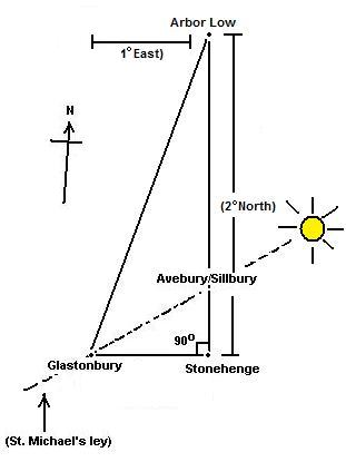 . .
Arbor Low sits 1 �
East
of Glastonbury Tor and 2�
North.
Arbor Low (53� 10' N, 01� 46' W),
Glastonbury Tor (51�
09' N, 2� 45' W).
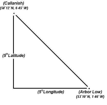
Arbor Low also sits 5 �
South of Callanish and 5�
East.
Arbor Low (53� 10' N, 01� 46' W),
Callanish (58�
12' N, 6�
45' W).
The apparently deliberate
placement of significant prehistoric sites by exact degrees of both
longitude and latitude is something that is also commonly seen in
other ancient cultures such as the Ancient Greek
oracles, several middle-eastern sacred sites, and in early
dynastic Egypt, all of which show high levels of Geodesy in the
placement of the most significant sites.
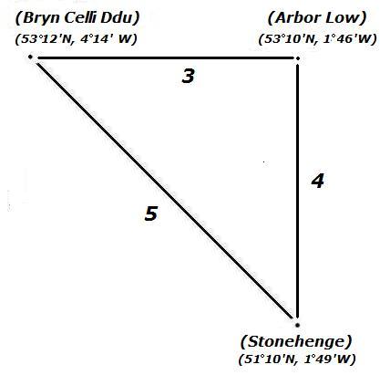
The Arbor Low
Henge-circle can also be seen to connect with another two henge-circles;
Stonehenge and Brynn Celli Ddu,
forming a Pythagorean 3:4:5 triangle on the landscape.
(More
about Arbor Low)
|
The Geodetic
Relationship between European Complexes. |
| Orkneys |
58�
59' 56" N, |
3� 11' 20" E. |
Positioned due to Lunar
phenomena (See above)
|
| Callanish |
58�
12' 12" N |
6� 45' 25" W |
Significant lunar Latitude:
(7� N, 4� W
Glastonbury), (7� N, 5� W Stonehenge), (5�
N, 2.5�
W Bryn Celli Ddu) |
|
Thornborough |
54� 12' 13.9" N |
1� 33' 24.84" W |
Latitude 1/10th planet circumference from Pole
(366�
division) 4�
S of Callanish. |
| Newgrange |
53�
41' 40" N |
6�
28' 30" W |
Inter-visible with
Tara Hill, (Sacred heart of Ireland) |
| Tara Hill |
53� 35' N,
|
6�
36' W |
(6�
N, 3.5�
W of Carnac),
(15� N, 1.5� E of Evora) |
| Bryn Celli Ddu |
53� 12' 30" N.
|
4�
14' 20" W |
(5�
S, 2.5�
E Callanish), (2�
N, 1.5�
E G'bury) |
| Arbor Low |
53� 10' N, |
01� 46' W |
(2�
N, 1�
E Glastonbury), (5�
S, 5�
E Callanish), (2.5�
E Brynn Celli Ddu) |
| Avebury/Silbury |
51� 25' 40'' N |
01� 51'
6" W |
(Latitude 360/7),
(St. Michael's Ley) |
| Stonehenge |
51� 10' 42'' N |
01� 49.4' W |
Significant solar/lunar Latitude:
(0.25� S of Avebury), (7�
S, 5� E Callanish) |
| Glastonbury |
51� 09' N |
2� 45' W |
(7� S, 4� E Callanish), (2�
S, 1.5�
W
Bryn Celli Ddu), |
| Carnac |
47� 35' 52" N |
03� 3' 47" W |
Significant solar/lunar Latitude:
(9� N, 5� E of Evora),
(6�
S, 3.5�
E Tara Hill) |
| Evora |
38� 33′ 28″ N |
08� 3′ 41″ W
|
Significant lunar Latitude:
(9� S and 5� W of Carnac),
(15� S, 1.5� W of Tara Hill) |
All the sites show separation by units of 1�
(accurate within 3' of a degree
or 95%)
|
Geometry in the British megaliths: |
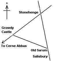 The
first professional suggestion of geometry at British Megaliths was by
Sir Norman Lockyer, the Astronomer Royale, who observed that Stonehenge,
Grovely Castle and Old Sarum are equidistant, forming an equilateral
triangle across the landscape. this geometry is reinforced by the fact
that the
Stonehenge-Old Sarum line continues another 6
miles to the site of the present Salisbury Cathedral, then onto the Clearbury rings and Frankenbury. The
first professional suggestion of geometry at British Megaliths was by
Sir Norman Lockyer, the Astronomer Royale, who observed that Stonehenge,
Grovely Castle and Old Sarum are equidistant, forming an equilateral
triangle across the landscape. this geometry is reinforced by the fact
that the
Stonehenge-Old Sarum line continues another 6
miles to the site of the present Salisbury Cathedral, then onto the Clearbury rings and Frankenbury.
The Stonehenge-Grovely castle line is aligned with the avenue (Stonehenge), which leads
away from Stonehenge, along the azimuth of the summer-solstice sun-rise. The
alignment
extends to the
North-East beyond St Peters mound, Inkpen beacon, and the Neolithic
'Winterbourne camp'. To the South-West the line continues past Grovely
Castle, Castle ditches and the 'Cerne-Abbas'
giant to Puncknowle beacon on the South coast
The Megalithic Yard.
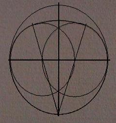
Prof. Alexander Thom
-
Radically suggested that geometry was used in the
design of certain prehistoric
sites (i.e. Avebury, left). He surveyed hundreds of European megaliths and concluded that
fundamental mathematic principles, based upon a common unit of measurement which he called the
megalithic yard,
had been applied in the
design of certain sites. As the megalithic tradition in Europe can be traced
back to at least 4,000 BC, if not earlier still, his work is still not
accepted by many archaeologists, although such a strong presence of
mathematics should not be ignored, as it clearly suggests that the design of
many sacred sites seems to have been based on a very sophisticated
philosophy of sacred science such as was taught centuries later by the
Pythagorean school.
As
Professor Thom observes in his book Megalithic Sites in Britain
(1967):
�It
is remarkable that one thousand years before the earliest mathematicians
of classical Greece, people in these islands not only had a practical
knowledge of geometry and were capable of setting out elaborate
geometrical designs but could also set out ellipses based on the
Pythagorean triangles.�
(More about Alexander Thom)
John Michell has became one of Britain's best known
recent Geomancers. His pioneering work on the alignments and geometry
between prehistoric sites won him acclaim at an early age. He is
remembered
for a number of significant geomantic discoveries.
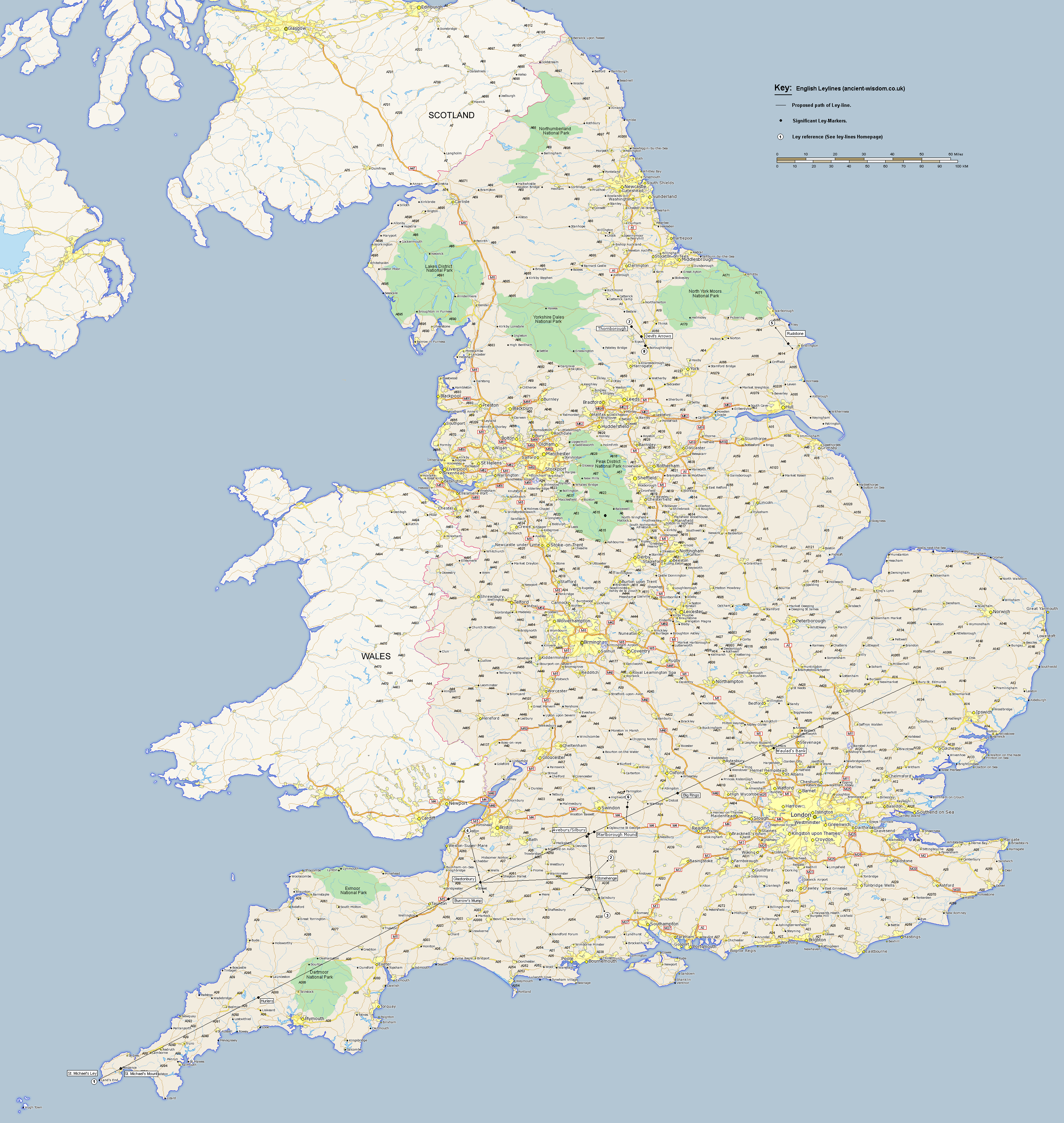
The St. Michael's Leyline.
One of Michell's best
known discoveries is the 'St. Michael's' Leyline, which crosses southern
England from Cornwall westwards all the way to Norfolk, passing several
prominent megalithic sites along the way. The alignment has a clear
association with astronomy, running along the azimuth of the may-day sun
(also known as St. Michael's day). The provenance of many of the sites
(i.e. The Hurlers, Glastonbury, Avebury, Walauds Bank etc) make it
likely that the alignment originated at some time in the late Neolithic
(c. 3,000 - 2,500 BC). Although the exact nature of this alignment is
still unknown, there seems little doubt that the St. Michael's ley is a
'linear' relic from a time when we were communicating our thoughts about
the universe through the alignment and orientation of ancient monuments.
The St. Michael's theme
is seen in ancient France as well, especially the site known as Mont St.
Michel, which connect to Glastonbury both geodetically and
geometrically. An alignment is also said to run across Europe connecting
all the sacred St. Michael sanctuaries in one huge alignment that
stats/ends in Israel.
The St. Michael's
connection is only just beginning to be understood.
(More
about St. Michael)
(View
the St. Michael's ley on a map of England)
Caesar's Triangle.
One of John Michell's less convincing theories was
his emphasis on the survey of Britain in early times , which he said
produced what he called 'Ceasar's
Triangle'. Quoting from Julius Ceasar's 'Commentarii de bello Gallico'
of 51 BC, he said the following on the subject:
'It is triangular, with one side
facing Gaul. One corner of this side, on the coast of Kent is the
landing place for nearly all the ships from Gaul, and points east; the
lower corner points south. The length of this side is about 475 miles.
Another side faces west towards Spain. In this direction is Ireland,
which is supposed to be half the size of Britain, and lies at the same
distance from it as Gaul. This side of Britain, according to the
natives' estimate, is 665 miles long. The third side faces north, no
land lies opposite it but its eastern corner points roughly in the
direction of Germany. Its length is estimated at 760 miles. Thus the
whole island is 1,900 miles in circumference' (3).
Although it is true
that in this description, the three sides when divided by 95, produce a
simple Pythagorean triangle with sides of 5, 7 and 9 respectively, the
description clearly places one corner on the coast of Kent which
suggests that the association between Britain and Pythagorean geometry
is symbolic rather than actual as the location is impossible with these
dimensions. We can see in the illustration provided
by Michell that he places the bottom right-hand corner somewhere in Gaul
(France) itself, completely ignoring the specific information provided by Caesar
himself.
The 'Great' Decagon.
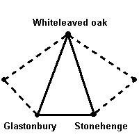 John
Michell first brought to the public attention the
existence of
a
large scale geometric figure which he dubbed 'The
Decagon' across southern Britain. The ancient Celtic
�perpetual choirs� at Llantwit manor, Glastonbury Abbey and Stonehenge were
said to be 'three vertices of a regular decagon of majestic proportions.
A fourth vertex exists at Goring-on Thames where a major pagan temple once
stood at the junction of several important track ways'. The centre of
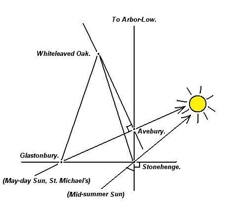
the decagon is at the apparently insignificant hamlet of Whiteleaved Oak
where the former counties of Hereford, Gloucester and Worcester came
together. This decagon is related by angle and distance to the other
geomantic centres of Britain. John
Michell first brought to the public attention the
existence of
a
large scale geometric figure which he dubbed 'The
Decagon' across southern Britain. The ancient Celtic
�perpetual choirs� at Llantwit manor, Glastonbury Abbey and Stonehenge were
said to be 'three vertices of a regular decagon of majestic proportions.
A fourth vertex exists at Goring-on Thames where a major pagan temple once
stood at the junction of several important track ways'. The centre of
the decagon is at the apparently insignificant hamlet of Whiteleaved Oak
where the former counties of Hereford, Gloucester and Worcester came
together. This decagon is related by angle and distance to the other
geomantic centres of Britain.
Note: Michael Behrend
supported Michell's original concept but made two small changes to the
original scheme. At present, no more than
three
vortices can be shown have a substantial enough accuracy
and
significance, although
their
distance and angle from each other certainly appears to be accurate
enough to suggest the possibility of a deliberate, rather than
incidental placement
in these cases.
The distance between Whiteleaved oak and both Stonehenge and Glastonbury
is startling, accurate to within 1/1000th part, both sites are placed
100.5km from the centre, forming an almost perfect Isosceles triangle.
The inclusion of Goring on Thames to the north-east , which sits on he
junction of the Ridgeway and the Icknield way, also shows an extremely
significant accuracy with an error of no more than 5 parts in 1000.
Whiteleaved Oak is situated at 52� 01' 20" N , almost exactly on the
52nd parallel.
(Click here for 1891
O/S map of Whiteleaved Oak).
The discovery of a
geometric relationship between
Glastonbury and
Stonehenge
is not unique. The
two sites are also associated with several other ancient structures in
Britain (such as the right-angled triangle formed with the inclusion of
Avebury/Silbury
(Arbor Low). The
strong astronomic and sacred
nature of these sites is reminiscent of
Lockyer's earlier theories concerning the alignment of such sites, and it is
tempting to conclude that such factors resulted in a geometric relationship.
However, such a synthesis by no means precludes the idea that
geometry itself was the original factor that determined the location
of the sites. It is therefore interesting to note that the 'Decagon' is
centred on the border of three counties (as is the Eastern end of the St.
Michael's Ley (Norfolk/Suffolk border), but which, apart from the 'sacred' name and
location on the 52nd latitude), has no association with either astronomy or
religion.
The most southerly edge of the
proposed decagon is between Glastonbury and Stonehenge. This line almost
sits on an almost accurate east-west axis (Approx 3�
west of true north). In relation to this, it can
be seen that a line from Glastonbury to the Avebury/Silbury complex
(being a part of the St. Michal's Ley, which follows the path of the sun
on may-day), simultaneously completes a perfect right-angled triangle
with Stonehenge. This simple observation illustrates the
underlying geometric connection not only between the three main
prehistoric sites of Southern England, but to several other prominent
prehistoric sites.
(More about 'The Decagon')
(Geodesy Homepage)
(Egyptian Geodesy)
|