|
Location:
Dorchester-on-Thames, Oxfordshire. |
Grid Reference:
51� 39' 11.01" N,
1� 10' 23.11" W. |
 Dorchester Big Rings:
(Henge complex).
Dorchester Big Rings:
(Henge complex).
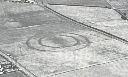
The Henge monument
to the north of Dorchester, known locally as the "big rings", was
sadly lost to aggregate extraction in the 1970s. (Not too dissimilar
to what is happening at Thornborough today).
Sadly, all that remains today is a crop-mark.
The Henge and
associated monuments were built over an existing Cursus monument,
something found at other sites such as Thornborough and Stonehenge
(which has the same circumference).
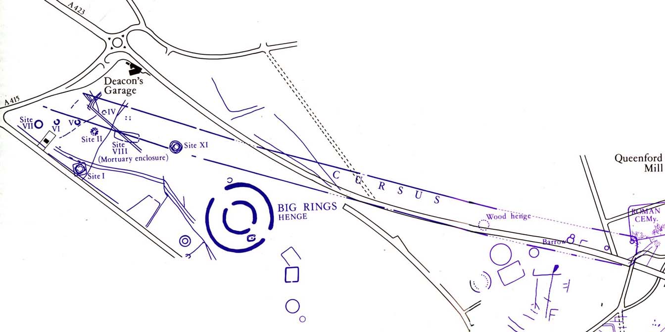
(Ground-plan
of Dorchester Henge and Cursus)
| The
Dorchester 'Big-Rings': |
The 'Big rings Henge monument at Dorchester on Thames, was part
of a complex of Neolithic and later monuments clustered around
the Cursus (SU 59 NE 5), and designated as site XIII within the
complex. First recognised as a crop-mark in 1927, some trenching
was undertaken in 1951-2 (including complete excavation of sites
XII and XIV). The excavations focused on the northern part of
the site, but included examination of the southern entrance.
The site comprises two concentric ditch circuits, with roughly
opposed entrances to the north-northwest and south-southeast.
The outer ditch has a maximum diameter of 193 metres, the inner
of 125 metres. Few finds came from the outer ditch - some
flints, plus a few Iron Age sherds. The inner ditch was a little
more productive. Finds from primary contexts included Beaker
sherds, struck flints and animal bones. Possible Peterborough
Ware and Collared Urn sherds were also present in the ditch
fill. A pit beside the north entrance dug into the inner ditch
contained Beaker and Iron Age sherds. The ditch fills suggest
the former presence of a bank between the ditches, and traces
were found during excavations in this area. A pit beneath the
bank material appears to have held a post. Features in the
entrance areas may be related to restricting access or blocking
but are of uncertain date. Very little was found in the interior
area excavated. Site XIV was located between the inner and outer
ditch circuits near the south entrance, while Site XII was
located just outside the north entrance. Much of the area has
since been destroyed by gravel extraction.
(1)
A
Neolithic Cursus at Dorchester on Thames, largely known as
crop-marks and partly excavated in 1947-52 and 1981. Much of its
course has been destroyed by gravel quarrying and the
construction of the Dorchester bypass. It comprised two broadly
parallel ditches circa 60 metres apart, running for at least
1600 metres in a more-or-less northwest-southeast direction. The
Cursus and its associated complex of monuments (see associated
records) run across the neck of a strip of land defined by a
bend in the River Thames and a tributary, the Thame. No
northwest terminal has been identified, while at the southeast
end, there appears to have been no formal terminal. Instead, the
Cursus incorporated an earlier D-Shaped enclosure ("Site 1" - SU
59 SE 163). Several interruptions of varying lengths are visible
along both ditches of the Cursus. The cursus also changes
direction slightly along its course. The north ditch changes
alignment once and the south ditch twice, although these changes
in direction do not coincide. In addition to Site 1, the cursus
is also pre-dated by the long enclosure known as SIte VIII (SU
59 NE 4). The southern Cursus actually cuts across this
enclosure, the Cursus ditch passing through the enclosure's
southeast entrance causeway (at which point the Cursus ditch is
also interrupted by a causeway). The best dating evidence for
the Cursus comes from this area. A polished flint axe came from
the primary fill, a lozenge shaped flint arrowhead came from the
bottom of the secondary silting, and sherds of both Ebbsfleet
Ware and Beaker were reported from the upper fills. An antler
from the primary fill has been dated to 3380-2920 BC
(calibrated), though whether this genuinely dates the Cursus
construction is open to debate. However, dating evidence
recovered from earlier and later monuments in the complex
supports a broad 2nd half of the 4th millennium BC date, in line
with Cursus monuments generally.
(2)
The
Dorchester-on-Thames Cursus was aligned on the midwinter sunrise
and would have been recognised as an important ceremonial site
for several hundreds of years.
(3).
(More
about Cursus)
Alignments and
Geodesy:
Christopher
Knight and Alan Butler have suggested that there may also be
evidence of use of a 366�
division of the globe in prehistoric times.
(4)
Their evidence shows that both
Thornborough and Stonehenge share similar dimensions which
appear to be based on circumferences of units of exactly 366�
megalithic yards. The now completely destroyed
Dorchester-on-Thames Henge once shared the exact same
circumference of 366 MY with the original 'Henge' at Stonehenge
= 1 MY per Meg degree of horizon.
Both
the Dorchester cursus and henge were both built directly on the
path of the St. Michael's Ley.
What's Happening Today.?
Oxford
County Council still has an ongoing gravel extraction plan
which threatens to eliminate every trace of this rich
Neolithic landscape:
Professor
Roger Mercer from Edinburgh
University, an expert on the
Neolithic and Bronze Age
described our stretch of the
River Thames as
"an
area of quite extraordinary
richness in terms of
prehistoric activity not
only in its British context
but when compared with an
equivalent area in
North-West Europe."
Professor Alasdair Whittle,
from Cardiff University,
also an expert of the
Neolithic, described the
area under threat as "a
complex prehistoric
landscape, with a startling
concentration of Neolithic
and Bronze Age monuments,
among other features, which
collectively constitute an
archaeological resource of
national significance,
comparable in importance for
example to those around
Avebury and Stonehenge."
Humphrey Case, former Keeper
of Antiquities at the
Ashmolean Museum in Oxford,
and an expert both on the
Neolithic and the
archaeology of the area, has
pointed to the importance of
the monuments in the PAGE
region: "This is one of the
few remaining crop-mark
complexes un-destroyed by
gravel quarrying in the
Upper Thames region, and
every effort should be made
to preserve it."
For further information and a
means of voicing your opinion on
this matter, follow this link:
http://www.pagecampaign.org/
(Other Henges) (Other
Cursus)
(St. Michael's Leyline)
(Prehistoric English Geodesy)
(Other Prehistoric English sites)
|