|
Location:
Derbyshire, England.
(O/S -
SK 160 636). |
Grid Reference:
53� 10' N, 01� 46' W. |
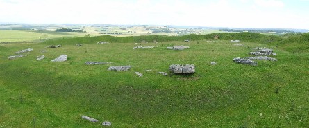
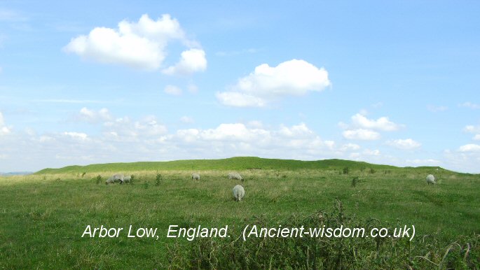
 Arbor Low:
(Henge II Circle)
Arbor Low:
(Henge II Circle)
.
Arbor Low and nearby Gibb Hill, once connected by an 'Avenue',
have been used on and off for thousands of years.
Arbor Low is considered one of the 'centres' of ley-line
activity in Britain.
The importance of the site is increased through its
geometric alignment with other significant English megaliths.
(Click here for Map of site)
|
Arbor Low
('Eordburh-Hlaw�) |
The site was called �Eordburh-hlaw� by the Saxons,
which means to be �built by giants�
Physical Description
-
This Henge-Circle was built near an ancient track-way (The
Penine Bridleway). It
is similar in design to
Stanton Drew,
Avebury,
Cairnpapple and the nearby Bull Ring.
This Neolithic
henge monument is composed of an earthen bank and ditch, a circle of
some 50 white limestone slabs, all now fallen and surrounding a central
stone 'cove' - a feature found only in major sacred sites.
(1) Skeletal
remains were found in the cove (With both hands and feet missing).
The original bank would have once stood at around 3m high, and the
limestone it was composed of would have shone a brilliant white.
The Limestone
stones have now all collapsed, but one stone at the west is still
slightly prostrate. Although the stones have the appearance of having
been toppled, there are no post-holes present, which suggests that they
may have never actually been erected. However, the antiquary Pegge
recorded that in 1785 that a local man aged 60 remembered some of the
stones still standing. In 1789, Pilkington recorded a similar account.
(2)
The Henge-circle sits on the South-facing sloping edge of the Derbyshire
limestone plateau.
(The Neolithic 'Great Barrow' at Minninglow can be seen from
the top of the Henge Bank).
Analysis of the monuments position has shown that
the ridge on which they lie occupies an "important watershed position", of
significance in relation to the way in which this limestone landscape appears to
have been occupied and used in prehistory (Barnatt and Collis 1996: 65).
(2)
|
Chronology:
While it is difficult to date the
monuments of Arbor Low and Gibb Hill with exact certainty, they are
proposed to be the result of cumulative episodes of use, which may have
continued from the Early to Mid Neolithic (c. 4,000 to 3,000 BC) into the
Early Bronze Age (c. 2,000 to 1,500 BC).
(2)
The Henge itself is
thought to have been constructed around 2,500 BC.
(2)
|
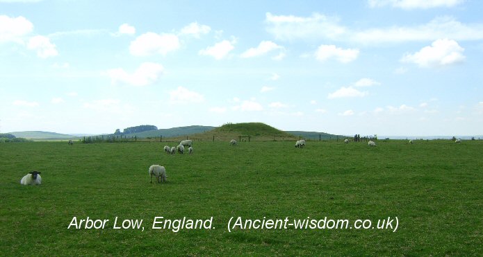
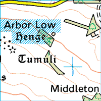
The nearby Gibb Hill Barrow, with which the monument
was once connected.
Alignments - Arbor Low's avenue,
like that of Stonehenge was composed of earth. A single low bank curves
away from the southern entrance, petering out in a field in the direction of
Gibb Hill (a huge mound barrow to the south west), the two monuments were
once attached by an earth ridge now called 'The Avenue'.
|
Arbor Low as a prehistoric
geodetic centre.
Arbor Low is considered by many to
be a centre of Ley activity in the British isles.
The significance of Arbor low is demonstrated in its
alignment with
Avebury
and
Stonehenge.
Because we know that Stonehenge, Avebury and Glastonbury form a right
angled triangle (accurate to within 1 part in a thousand) (click here
for details), it means by inference that Arbor Low is also the northern
most point of a large right angled triangle with Stonehenge and
Glastonbury.
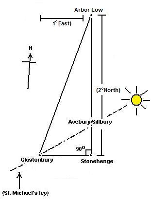 . .
Arbor Low sits 1 �
East
of Glastonbury Tor and 2�
North.
Arbor Low (53� 10' N, 01� 46' W),
Glastonbury (51�
09' N, 2� 45' W).
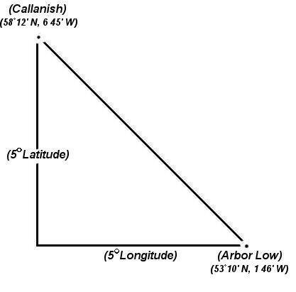
Arbor Low also sits 5 �
South of Callanish and 5�
East.
Arbor Low (53� 10' N, 01� 46' W),
Callanish (58�
12' N, 6�
45' W).
...and 5.5�
North (and the same longitude) as
Mont St. Michel in France.
Arbor Low (53� 10' N, 01� 46' W),
Mont St. Michel (48�
39' N, 1�
46' W).
And finally, it can be seen that
Arbor Low and Stonehenge are connected to
Bryn Celli Ddu, in Wales through
'Pythagorean' geometry.
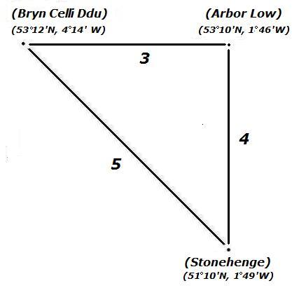
It is noticeable that one of
the internal angles created the 3:4:5 triangle is 53� 10', the same
as the latitude it sits on. This same geometric fingerprint is found
at Stonehenge (In the alignment of the 'Avenue').
The apparently deliberate
placement of significant prehistoric sites by exact degrees of both
longitude and latitude is something that is also commonly seen in
other ancient cultures such as the Ancient Greek
oracles, several middle-eastern sacred sites, and in early
dynastic Egypt, all of which show high levels of Geodesy in the
placement of the most significant sites.
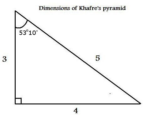
The latitude of 53� 10' is the
same angle as that produced by the 3:4:5 Pythagorean Triangle. It is
also coincidentally, the same as the exterior angle of
Khafre's Pyramid at Giza. This
same geodetic phenomena is repeated with The 'Great Pyramid and
Silbury Hill, both of which have exterior angles which reflect the
others latitude.
(More
about English Geodesy)
(More about Geometric Alignments)
|
Astronomy:
The cove
at the centre of the circle faced the moons maximum midsummer setting.
Gallery of Images: Arbor Low..
(More about Henges)
(Prehistoric Geodesy)
(Other Prehistoric English sites)
|