|
 The Salisbury Complex:
(Sacred Landscape).
The Salisbury Complex:
(Sacred Landscape).
There are
several noticeable concentrations of Neolithic sites along the western
Atlantic coast. These prehistoric complexes can be seen at locations
as far apart as the Orkneys in Scotland, the Boyne Valley
in Ireland, Carnac in France and Evora in Portugal, all of which
share similar features and all are contemporary. The Salisbury
landscape retains the same indelible fingerprint of
unprecedented civil-scale prehistoric
activity and the remains of some of the largest prehistoric
monuments from the ancient world. Landmarks such as Stonehenge,
Avebury and Salisbury dominate the prehistoric the landscape,
but other sites such as Durrington Walls, The Sanctuary, West Kennet Long-barrow
and Old Sarum (to name but a few), were also parts of this
ancient landscape, all operating together to create what is
often termed a 'sacred' or 'living' landscape.
Archaeology has
revealed that associations do exist between these complexes
(through discoveries of both Grooved-ware and Beaker-ware), and
while it is not yet possible to say that there was a direct
connection, the arrangement of monuments at each complex can be
seen to provide the means for an accurate localised measurement
of both the cycles of the sun and moon, and evidence suggests that the distribution and placement of
the most prominent European monuments goes beyond random
selection (see below).
Suggestions of
astronomical observations in the region can be seen dating back over
8,000 years (through the Stonehenge Post-holes). It is perhaps
no coincidence that the Goseck Henge
in Germany lies on the same latitude as Stonehenge
supporting the idea that the preference for this latitude was no coincidence. The
astronomical significance of this latitude (being the specific
latitude at which the maximum zeniths of the sun and moon cross
at 90� of each other), is a clear suggestion behind
the motivation for such intense construction activity, but without
a more complete context the overall picture of events eludes us.
However, recent
observations are starting to show that not only is the local
landscape woven together, but that it extends outwards to
other important and contemporary prehistoric sites leading to
a suggestion of the deliberate separation of complexes according
to a basic set of basic
astronomical and geometric principles.
General Description of the Area:
The Wiltshire complex includes some of the
largest man-made constructions from the prehistoric world leaving no
doubt as to the importance of the area. (The estimated man-hours for
Silbury and Avebury alone are in the region of 5 million man-hours).
We now know that the majority of the works in the area were carried
out over a broad period of around 600 years, with two distinct
periods of construction (c. 3,100 and 2,400 BC).
The original reasons, driving force, and the organisation
behind such civil-scale activity is unknown to us and we are forced
to speculate on much today, but there are certain clues which
suggest that the design and arrangement of these huge civil
structures was aimed at creating a larger arena, uniting the
Salisbury landscape in an unprecedented way.
Human
activity in the region extends back to the Mesolithic era, and
continues to the present day. The complex can be loosely divided into
two groupings of significant sites; The northern group which
includes Avebury, Silbury, The Sanctuary and West Kennet long-barrow,
and the southern group which includes Stonehenge, Old Sarum, The Cursus, Durrington Walls, and the newly discovered 'Bluestone
circle'. Why this particular area was chosen, and
what it was original function was are still amongst the most challenging
questions about the complex.
The appearance of the Avebury
monuments would have been completely different when they were first completed,
more in line with other large monuments in Britain, being
covered with a white surface of chalk from which they were dug. Silbury
Hill would have seemed like a snow covered mountain, and the ditch and
bank of the Avebury circle would have shone white against the
surrounding landscape. Likewise would have been the mounds of the
numerous long-barrows and tumuli that were commonplace in the area. It is
of interest to note that the earlier passage tomb of Newgrange in Ireland's Boyne Valley included a
spectacular surround of white quartz when it was built.
This quartz was quarried in the Wicklow Mountains some
50 miles away indicating that some Neolithic builders
would make a great effort to give their constructions a
white appearance. Excavation of
the three large Henges at Thornborough in Yorkshire revealed that the banks of these substantial earthworks
were deliberately made to appear white by the
application of layers of gypsum which had to be
transported to the site(s). Whether this has any
connection with Avebury is yet another question our
Neolithic ancestors have left us to consider
(3)
We are reminded that the first
'Blue-stones' from Wales are now proposed to have been included into
the first phase of construction at Stonehenge (c. 3,100 BC),
discounting the argument that the Salisbury area was selected for
its availability of Sarsen stone.
(The Specific Selection of Stones)
All the sites within the Wiltshire complex have different designs
and presumably served different functions to different peoples at
different times, being built over a period of several hundred years,
but the resulting combination marks one of the largest Neolithic
complexes in the world, and requires a better understanding in order to
explain the context behind such energy and design.
The division of the complex into two distinct clusters of
sites, with the Stonehenge grouping in the
South and the Avebury grouping in the North is of clear importance
and perhaps it is through the connectivity between these sites
that we can begin to learn their association and purpose.
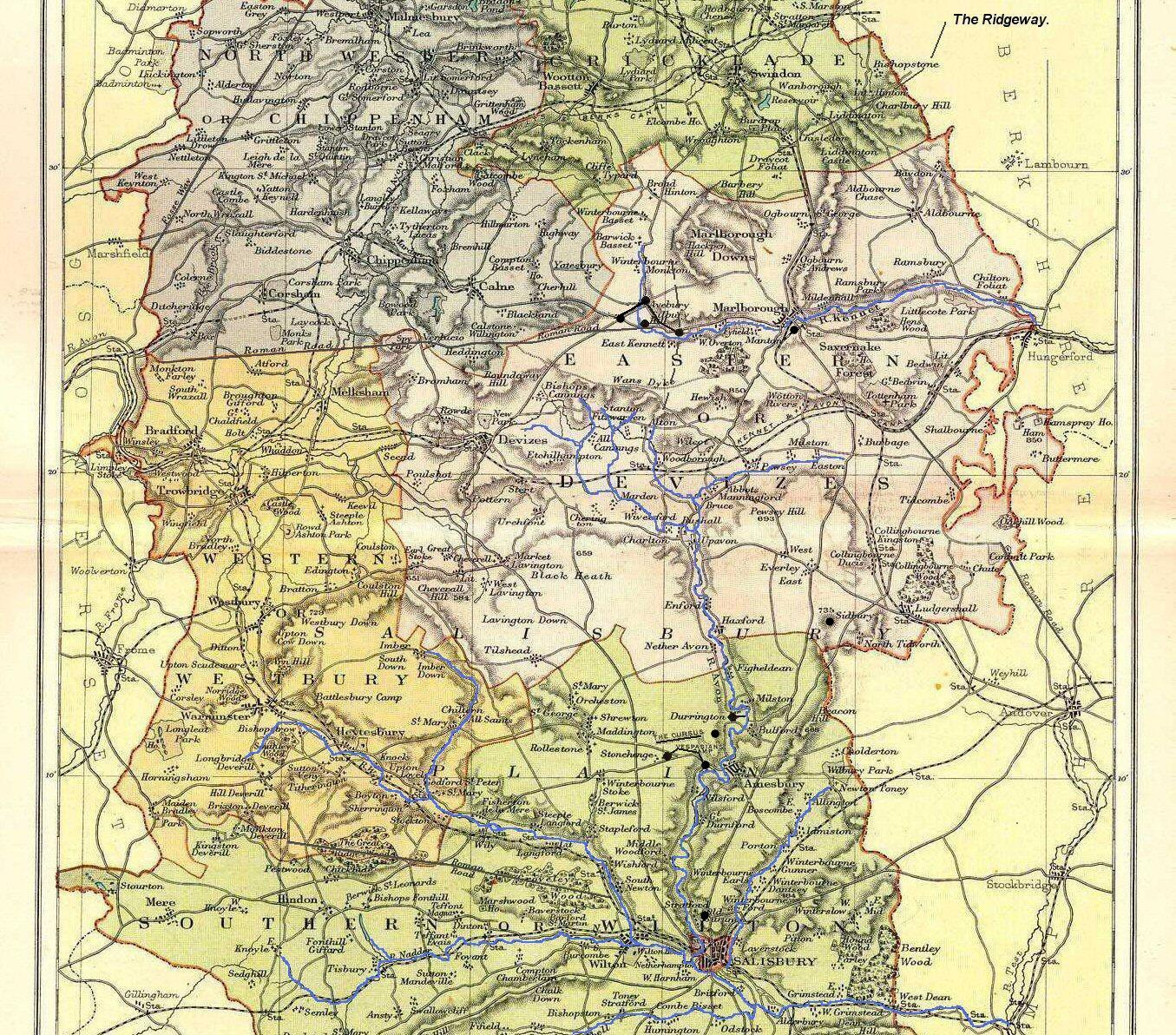
Geographically, the Northern Avebury
cluster is the terminal point of both the Ridgeway and the Icknield
way. Although there appears to be no physical connection today, it
is likely that the River Avon was used to convey people from the
northern area to the southern area, as it starts only
a mile or so south of Avebury and
flows south directly past Durrington Walls, Stonehenge and Old Sarum,
then on south
to the coast.
The Pre-Pre-History of the Region (Before
Stonehenge, Avebury and Silbury).
The fame of Stonehenge has for a long time
overshadowed the larger picture of activities in the Salisbury area. It is now much more reasonable to
view it as a single component of the larger, inter-connected
Salisbury landscape.
Archaeologists have found four, or possibly five
large
Mesolithic
postholes which date to around 8,000 BC, beneath the nearby
modern tourist car-park (6). These held pine posts around 0.75 metres (2ft 6in) in diameter which were erected and eventually rotted in
situ. Three of the posts (and possibly four) were in an
east-west alignment which may have had
ritual
significance; no parallels are known from Britain at the time but
similar sites have been found in
Scandinavia.
Salisbury Plain was then still wooded but 4,000 years later,
during the earlier Neolithic, people built a
causewayed enclosure at
Robin Hood's Ball and
several
long barrow tombs in the surrounding landscape. In approximately
3,500 BC, the vast
Stonehenge Cursus was built 700 metres (2,300 ft) north of the
site as the first farmers began to clear the trees and develop the
area.
(6)
A thousand years before Stonehenge,
Avebury or Silbury existed, the (3km long) Cursus had been
built in the area (c.3,630 - 3,375 BC)
(4)
The cursus was aligned on
the equinox sunrise which rises over the eastern long barrow. at
around the same time the region was also home to the 'long-barrow'
builders. The long-barrow builders (Windmill hill culture) built
over 300 barrows in Britain but the highest concentration is in Wiltshire,
and they date from c. 4,000 BC - 2,500 BC. It is probable that any
monuments that were built after them, were built with them in mind.
For example, the Beckhampton cove/long barrow and the Sanctuary are
both estimated to date at c.
3,100 BC, but were only physically connected c. 2,400 BC through the
construction of the Beckhampton and West Kennet Avenues via Avebury.
All these indications are that the region
already held a special significance to the future builders of these
great monuments before they built them. Of interest perhaps,
that a similar construction to the original design of Stonehenge was built on the same latitude at
Goseck in Germany, but long before
Stonehenge was constructed (c. 5,000 BC). This particular latitude
is the only latitude at which the sun and moon have their maximum
azimuths at right angles to each other, a feature which was included
in one of the earliest features at Stonehenge in the shape of the
Station-stones.
The Major Construction Phases (c. 3,000 BC and
2,400 BC).
The importance of the area appears to have
culminated in two intensive construction phases at around 3,000 BC
and again c. 2,400 BC. It is perhaps no coincidence that the
Salisbury Complex is home to both the largest man-made mounds
in Europe, the most sophisticated stone circle and the two largest Henges in the World.
The tens of millions of man hours involved in creating all the
monuments during this time are only surpassed by the overall
planning and design involved, something which is often ignored, but
which suggests the presence of sophisticated cultures. A lack of burials
beneath Silbury hill precludes the notion that it was a ritual
burial mound, so how are we to explain the impetus behind such
structures?.
The discovery of Beaker-ware at most of the sites
in discussion, leaves little doubt as to who the builders of these
great monuments were, but we are told that the Beaker people arrived
in England c. 2.500 BC. with the earliest examples of their pottery
being found in Iberia c. 2,900 BC.
(15)
which precludes them from the earliest phases of work, but places
them exactly in the right place and at the right time for the
majority of the works c. 2,500 -2,400 BC. The question remains
however, in what context was such work undertaken?. The Beaker people's arrival c. 2,500 BC can be
seen as part of a wave of immigration that occurred along the
Mediterranean basin and the Western coast of Europe at that time.
Sites that had already been in use such as Carnac, Boyne Valley, Salisbury, and the Orkneys all show evidence of great building works
at this time, but they also show that the monuments were built over
existing Megalithic centres. Putting it simply, it seems that
the Beaker people arrived and almost immediately began to adapt or
convert existing significant monuments (and their meaning) in
perhaps a similar way the Romans integrated cultures into their
empire as they expanded throughout Europe and beyond.
If, as it seems, the important important
megalithic complexes were already in place when the Beaker people
arrived, there is still the question of who originally conceived and
initiated such grandiose works. Before their arrival for example,
the first (and arguably most important) phase of works had already
been carried out at Stonehenge, with other sites such as Old Sarum
and
the Sanctuary showing signs of activity at the same time (c. 3,100 BC).
This same pattern is repeated at other Megalithic complexes along
the Atlantic coast of Europe and in each case we see the common
theme of adaptation rather than initiation.
Stepping back several hundred years to the
initial phase of construction (c. 3,100 BC) takes us into a largely
unknown yet globally significant period of prehistory. At present our knowledge of events at
this time is limited as it also signifies the beginning of the
written record, and trying to reconcile evidence of
such a concerted exercise with our knowledge of what we know from this
time relies on an element on speculative research. So where are we to look
for the skills and organisation required to initiate such large
scale works?. The primary candidate at present is the
ignominiously named 'Grooved-ware' people. Pottery from
this culture has dominated our impression of them, but it was these
people that brought the first Henge monuments to Britain (likely an
adaptation to the cursus), with discoveries being found at Newgrange, the Orkneys,
Thornborough, Arbor Low and
Salisbury. It is currently speculate that the 'Grooved-ware' people
originated within Britain, probably in the region of Ireland or
Scotland, extending southwards c.3,000 BC.
(20)
It has also been suggested that the Grooved Ware people represented
'an emerging elite within Neolithic society'.
| Description
of the Major Monuments: |
The Major Monuments of the Wiltshire Complex.
The Salisbury
complex can be divided into two distinct clusters of sites; The
Southern Group surrounding Stonehenge, and the the Northern
group surrounding Silbury Hill.
(Map
of the Salisbury Complex)
The Southern (Stonehenge) Sites:
Stonehenge:
The specific location of Stonehenge was in use
from the Mesolithic (c. 8,000 BC) as determined by the presence of
several large post-holes in the car park.
(6).
Three of the posts were placed in an east-west alignment. Around
4,000 years later (c, 3,500 BC), the almost 3km Cursus was built
near where the Stonehenge monument would begin its first
construction phase 500 years later. The Cursus was designed to run
in line with the sunrise on the spring and autumn equinoxes. Both
these facts suggest an early understanding of the basic principles
of astronomy before Stonehenge even existed. Exactly when it was
realised that this latitude was
'the exact latitude at which the Midsummer Sunrise and
Sunsets are at 90� of the Moons
Northerly setting and Southerly rising'
is not known. However, this fact does appear to have been
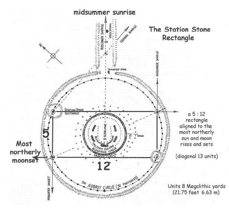
incorporated into the first phase of Stonehenge through the
arrangement of the
Station Stones. It is perhaps also worth noting that the
Goseck Henge in Germany was
constructed c. 5,000 BC. It is of a similar design to the first
construction phase, and lies on the almost exactly the same
latitude.
First Construction Phase: 3,100 BC
(6).
This is the same time that work begins on the Northern section of
the Salisbury complex, at both Avebury and Old Sarum. In addition,
civil-scale constructions simultaneously appear in the Boyne Valley,
Ireland, Carnac in France, Evora in Portugal, on the Orkney Islands
in Scotland and on Malta. It is noticeable that this exact time is
also ascribed to the start of the Egyptian dynasties and pyramid
building. It will be shown that all of these locations share a
common theme in construction, geometry and astronomy. They are also
related through Geodesy, by separation through units of degrees of
longitude and latitude (based on a 360 division of the globe).
The specific location of the Stonehenge monument
c. 3,100 BC placed it approximately 15 miles south of
the
northern Avebury cluster. The 'Sanctuary', which later became
connected to the Avebury monument, shows activity from the same
time period and was built on the same longitude of 1� 49' W and is exactly 1/4�
north revealing the first of many 'coincidences' regarding the
placement of other significant sites in relation to these two
markers. (see below)
(More about
Stonehenge)
The Bluestone Circle:
The Newly discovered 'Bluestonehenge'
was made of 25 massive bluestones, erected in a circle about 5,000
years ago, and eventually were encircled by a ditch and an earthen
embankment. About 500 years later, however, the stones were moved
and incorporated into Stonehenge itself. The monument was found at
the beginning of an avenue leading to Stonehenge and near the river
Avon, which "not only solidifies the view that Stonehenge covers the
entire landscape, but also the sacred importance of the river
itself," said archaeologist Christine Hastorf of UC Berkeley.
So far, it is believed that there was a 30-foot-wide
circle of about 25 standing stones. The dimensions correlate precisely with those of bluestones in the
inner circle of Stonehenge.
The stone circle at 'Bluestonehenge' was eventually replaced by a
henge, a circular ditch nearly 74 feet across with an external bank.
Broken antler pickaxes in the ditch date its construction to about
2470 BC to 2280 BC. At least one entrance has been discovered, on
the east side, and it contained a specially placed deposit of
antlers, an antler pickaxe, cattle bones and stone and flint tools.
The team also found the riverside end of the avenue to Stonehenge. It
was marked by two parallel ditches about 54 feet apart. These
originally held posts, forming a small palisade on either side. The
avenue apparently terminated at or close to the outer bank of the
newly discovered henge.
Archaeologist Josh Pollard of Bristol University, a co-director of the
project, noted that the circle "should be considered an integral
part of Stonehenge rather than a separate monument, and it offers
tremendous insight into the history of its famous neighbour."
Previous research had shown that Stonehenge originally consisted of 56
bluestones set in a circle inside a ditch and bank. Sometime about
2500 BC, those stones were moved to their current location, leaving
behind the holes now known as Aubrey holes. But there are 80
bluestones in Stonehenge and only 56 Aubrey holes, Parker Pearson
said. (23)
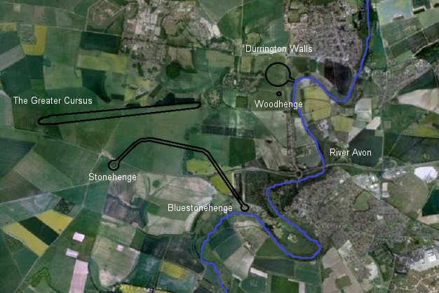
The 'Ceremonial' Avenues of
Stonehenge and Durrington Walls connect them together with the River
Avon.
Durrington Walls: Evidence of Neolithic habitation at the site, but
the monument was constructed between 2,600 - 2,400 BC. Estimates
range at around one million man-hours in construction. The largest
Henge in Britain and now seen as a complimentary structure to the
Stonehenge site (13).
Local finds of Beaker-ware, and the discovery that one of the homes
excavated within the site was 'remarkably similar in layout to a
house at Skara
Brae in Orkney' (14) draws clear a clear association between
this monument and others seen at contemporary Neolithic complexes
along the Western Atlantic coast.
The first timber circle c. 2,600 BC was oriented
southeast towards the sunrise on the midwinter solstice and a paved
avenue was also constructed on a slightly different alignment �
towards the sunset on the summer solstice which led to the River
Avon.
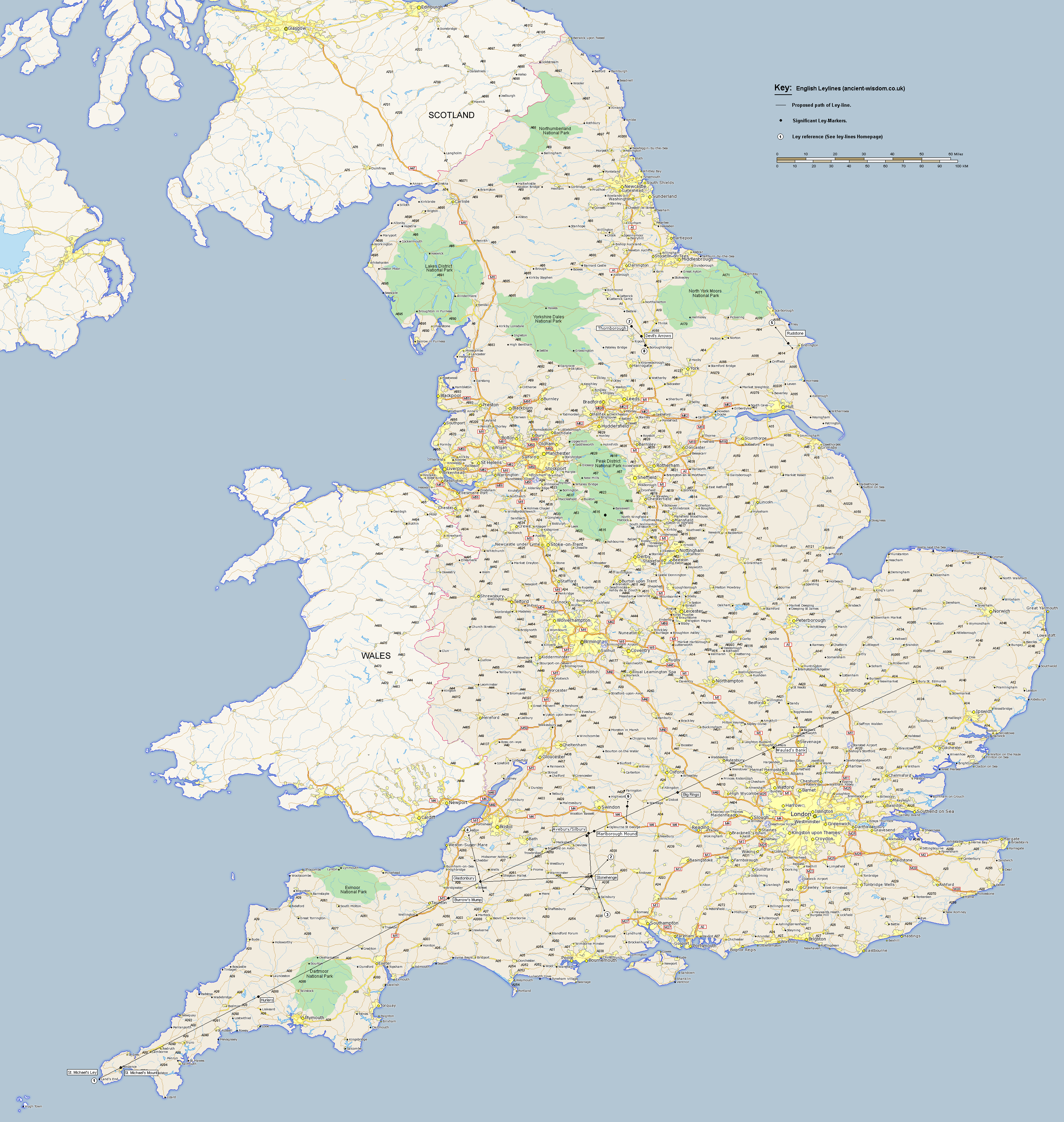
Old Sarum:
Inhabited since 3,000 BC
(5). Old Sarum lies on
one of the earliest recognised examples of leylines as determined by
Sir N. Lockyer. It lies directly in line between Salisbury and
Stonehenge. Before Salisbury Cathedral was built, Old Sarum was the
seat of religious power until Salisbury Cathedral was built c 1250
AD. Legend has it that the Bishop of Old Sarum shot an arrow
in the direction he would build the cathedral; the arrow hit a deer
and the deer finally died in the place where Salisbury Cathedral is
now. The alignment between sites can be seen to extend beyond Old
Sarum, with indications that it was a deliberate alignment from the
outset.
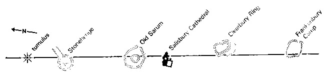
It is significant in that it lies on the same
azimuth as the Glastonbury Ley, and is approximately the
same length.
(More about Old Sarum)
The Northern (Sanctuary) Sites:
The Sanctuary:
Constructed C. 3,000 BC
(24). this potentially one of
the most important sites of the Salisbury complex along with
Stonehenge. It began life as several circles of post-holes, being
later converted into a circle of stones around 130ft across (larger
than Stonehenge). It was the terminal (entry) point of the West
Kennet Avenue, and apart from the later Marlborough mount, was the
nearest accessible construction to the river Kennet. It is also
uniquely positioned at the end of the Ridgeway and the start of the
West-Kennet River, in such a way that all the other important
monuments in the local area (some built before, and some after) can
be seen from it.
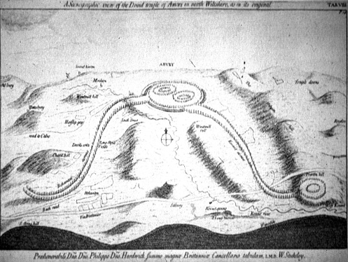
Stuckley viewed the
Sanctuary as the 'head' or 'Hakpen' of a huge ceremonial 'snake'.
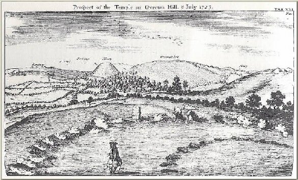
The only surviving image with the
original stones in place. (1723. W. Stuckeley)
This importance of this site has gone unnoticed
for a long time, but its natural position as the entrance to the
Avebury complex hides another startling fact, which is that its
location places it at approximately 1/4 of a degree north of Stonehenge,
and they both lie on the exact same longitude. This revealing
clue is one of several key facts which suggest that the monuments of
the Salisbury complex were located at deliberately significant
astronomical, geometric and geographic locations which united the
landscape in the eyes of the builders.
(More about the
Sanctuary)
Avebury:
The Avebury monument is arguably the largest
monument in Britain with estimates of around 1.5 million man-hours
involved in its construction (11). It has four entrances,
approximately orientated to the cardinal points and it houses both
the second largest Henge and the largest stone circle in the world
composed of 98 vast sarsen stones highlighting its importance in the Salisbury complex.
There are 98 lunar cycles per 8 solar cycles, suggesting the
possibility of a primitive alternative to the Metonic cycle. Construction started at around 3,000 BC with the
Cove and finished at around 2,400 BC, with the placement
of the west Kennet and Beckhampton avenues.
The two stone avenues (Kennet
Avenue and
Beckhampton Avenue) that meet at Avebury define two sides of
triangle that is designated a
World Heritage site and which includes
The Sanctuary,
Windmill Hill,
Silbury Hill and the
West Kennet Long Barrow and Beckhampton Cove. Many of these
sites were in existence before Avebury was constructed.
Avebury is situated half way along the St. Michael's Ley, (on the
ancient path of the Iknield way), which was aligned to the sun on
Beltane (A cross-quarter day marking the first day of Summer). The
Avebury complex also represents the southern terminus of the
Ridgeway. Avebury is located at the latitude (360/7 =
51.42857). (10)
Empirically, not only does Avebury Henge straddle the latitude
equalling one-seventh of the circumference of earth, but the orientation from
Avebury to the Sanctuary (51.51�) is the same as both the latitude of
Stonehenge and the orientation of the Avenue leading from Stonehenge
(Aligned to the midsummer solstice). Avebury lies north of
Stonehenge by exactly 1/4� latitude.
(More about Avebury)
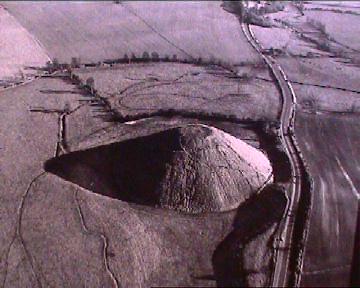 Silbury Hill: Silbury Hill:
Silbury was completed c. 2,500 BC, just a hundred years
before the Avenues. It is the largest man-made construction in
prehistoric Europe with estimates of man-hours in the range of 4
million man-hours
(11).
Apart from the vast amount of manpower required, the construction of Silbury demonstrates
a high level of sophistication which begs the question: Where did the knowledge of building in this way arrive
at Avebury? It has revealed no evidence of burials or incarnations,
and as yet remains to be explained in terms of our traditional
understanding of events in the Neolithic.
Silbury sits in the centre of the Avebury
complex, almost hidden from view for the most part. The top of the
hill has a way of lining up with the horizon level from several
angles, and is inter-visible with both Avebury and the Sanctuary.
The hill was originally thought to have been deliberately surrounded
by water, being positioned over the source of the River Kennet. This
design feature has led to suggestions of it representing the 'primal
mound', or the belly of the pregnant 'earth mother'.
The flattened top of Silbury measures
100ft in diameter, the same as the
exterior diameter of the Stonehenge
sarsen stones.
(More about
Silbury Hill)
The West-Kennet Avenue:
Constructed c. 2,400 -2,200 BC to connect the
pre-existing
Sanctuary to Completed Avebury monument.
Excavations by
Stuart Piggott and
Alexander Keiller in the 1930s indicated that around 100 pairs
of standing stones had lined the avenue (at this time only 4
remained standing), and that they dated to
around 2,200 BC based on finds of
Beaker burials found beneath some of the stones. Running
for a length of over half a mile, the 50ft wide avenue is often
suggested to have been composed of alternating male/female
(lozenge/phallic) shapes, however, only a sad few remain today.
The Beckhampton Avenue:
Constructed c. 2,200 BC. A second avenue, called
the
Beckhampton Avenue led west from Avebury towards the existing Beckhampton
Long Barrow, constructed c. 3,200 BC (7). The majority of stones
have since fallen or are missing. Excavations by the
University of Southampton in 2000 revealed the parallel rows of
holes that held the stones of the Beckhampton Avenue. Approximately 120m of the avenue was uncovered and indicated that
the avenue consisted of a double row of stones placed at 15m
intervals in a similar pattern to those at the
Kennet Avenue.
Stuckeley's view of the
formed across the landscape with the West Kennet and Beckhampton
avenues.
Beckhampton Cove and Long-Barrow:
Sitting at the end of the Beckhampton Avenue, and
arguably the reason for its construction, lie the 'Longstones' or the
'Devil's Quoits' which are two large monolithic
stones, suggested to bethe remains of what was once a prehistoric
'cove' of
standing stones similar to the one in Avebury. The avenue probably
terminated here although it may have extended further to the south
west beyond the stones. The Beckhampton long barrow, dating from c. 3,200 BC runs
in line with the Beckhampton Avenue to Avebury, and more
importantly, along the axis of the St. Michaels Leyline, which means
that it too was orientated to celebrate 'Beltane', a cross-quarter
day, marking the first day of summer and the midpoint in the Sun's
progress between the spring equinox and summer solstice.
Marlborough Mound: Dated to 2,400 BC
(8)
The size and location of this mound make it a relevant addition to
the ancient landscape. At two-thirds the height of Silbury Hill, it
becomes the second largest mound in Britain and potentially all
Europe and would have required at least a million man-hours to
complete. It lies five miles distant, and exactly east of Avebury.
Its construction at the same time as its larger relative (Silbury
hill), and E-W orientation between sites suggest an astronomical
significance.
(Map
of the Salisbury Complex)
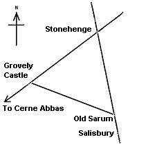
The
first modern astronomical observations of the monuments on the
Salisbury landscape were recorded at the turn of the 20th century by
Sir Norman Lockyer (then the Astronomer Royal), who noticed both
that the avenue at Stonehenge was orientated along the path of the
Summer Solstice sun, and that Stonehenge, Grovely Castle and
Old Sarum formed a near-perfect equilateral triangle, with each side
6 miles in length (All of these alignments are now known to extend
onwards to other prehistoric sites).
These connections, both astronomical and
geometric set the foundation for future observations of the
monuments in the area. Alfred Watkins 'stumbled' across the theory
of Leylines, followed closely by Prof. A. Thom, who continued his
research along the same lines as Lockyer, eventually revealing the
(still controversial) common unit of measurement which he called the
Megalithic Yard. He became convinced of the existence of skilled
'elite' group of people (i.e. astronomer/priests) who organised the
design of many of the major European constructions - we are reminded
of the suggestions of an emerging Neolithic 'elite' in the shape of
the 'Grooved-ware' people.
Having taken a look at the individual sites, it is
now worth looking closer at the connections between sites. Apart
from the obvious connection between the Sanctuary, Avebury and
Beckhampton in the shape of the West-kennet and Beckhampton avenues,
other sites such as Silbury, which was not connected physically, can be
seen to be integrally linked through their specific locations and
inter-visibility with other noticeable sites. For example, Avebury, Silbury Hill,
the West Kennet Avenue and both the East and
West-Kennet long-barrows are all visible from the Sanctuary. From Avebury,
Windmill Hill and the Sanctuary, the top of Silbury hill lies
in line with the horizon, while from the West Kennet Long-Barrow,
the top of Silbury appears to be on the same level. These ground
observations all add to the otherwise unseen aspects of the symmetry
between the monuments and the landscape.
Of more fundamental
importance but less visible to the naked eye, are the connections
between sites through astronomy and geometry. The addition of these
elements greatly adds to the significance of the monuments,
reinforcing their symbolism and extending their presence beyond
their physical footprint to unify the landscape, but it also reveals
a system of measurements that suggests a higher level of knowledge
to these builders than is normally accredited. It is a
particularly interesting fact for example, that apart from being
positioned on the same line of longitude as Stonehenge, the
Sanctuary, which was occupied at the same time is positioned exactly
1/4 degree north of Stonehenge. This remarkable fact connects both
the Northern and Southern clusters of the Salisbury complex in a
single earthly measurement
(based on a 360 division of the globe). The same apparent
recognition of earthly measurements is seen in the fact that
Stonehenge was built on a latitude mirrored by the zenith of the
summer solstice sun, while the Avebury monument was built on a
latitude (51.428) which is the result of 360/7. Other important
ancient sites such as Delphi in Greece and both Giza and Karnack in
Egypt also conform to this system of geodetic placement. (More on
this below).
(More
about Egyptian Geodesy)
There has been a gradual recognition in recent
times that certain stones at megalithic sites appear to have been
carried long distance to their final destinations. There is a clear
suggestion here that individual qualities of stone were a
consideration in the construction of 'sacred' sites. The effort
required to transport stone were presumably balanced by their
importance. Several sites have now been recognised as being composed
of 'pieces of places', something which would seem to play an
important role in the development of the Salisbury monuments,
especially in light of the famed 'Sarsen Stones' transported from
Wales for the first phase of construction at Stonehenge. In all, at
least 20 rock types have been identified at Stonehenge
(21)
The connection between these two prominent and
contemporary Salisbury monuments in itself is a challenge, but to
take matters further, it seems that these alignments extend onwards
to other prominent Neolithic sites, also being separated by
units of degrees, and/or the same Geodetic placement associated with
astronomy and geometry. It can be seen, for example that the same
line continued another 1 1/2 degrees north arrives at
Arbor-Low 'The Stonehenge of
the North', constructed at around 2,400 BC, but with activity
extending back to c. 4.000 BC. Arbor Low is in return aligned
geodetically with several other significant British monuments such
as Bryn Celli Ddu and Callanish. The latitude of Arbor-Low
(53� 10' N) is the
same angle as that produced by the 3:4:5 Pythagorean Triangle. It is
also coincidentally the same as the exterior angle of the
Khafre Pyramid at Giza. These
facts lend weight to the suggestion of a common underlying
system of geodesy in operation through the placement of ancient and
significant sacred sites.
(More
about the St. Michaels Leyline)
Silbury shares a curious 'coincidental' geometric
connection with the Great pyramid of Giza, in that the exterior
angle of the great pyramid is mirrored in the latitude of Silbury,
which in turn shares its exterior angle with the latitude of Giza.
It is perhaps of interest in relation to this that the dimensions of
the top of Silbury are the same as the circumference of Stonehenge
(revealed to be a quarter-aurora in Egyptian measurements). The
result of this circumference is that each degree on the horizon
measures half a megalithic yard. This association between
the exterior angles of pyramids and the latitude can be seen
elsewhere in the Middle east, and as we have seen, the latitude of
Arbor Low is associated with both fundamental geometry, and lies on
the Salisbury meridian, exactly 2� north of Stonehenge, something
which suggests a similar set of principles underlying the placement
of European monuments.
We have seen that the earliest phase of
construction at Salisbury involved both Stonehenge and the Sanctuary
amongst others, both these monuments appear to be related through
their longitudes and latitudes, being exactly 1/4 degree of latitude
apart, while lying on the exact same longitude. The implication of a
deliberate separation between sites, presumably working away
from Stonehenge, offers a new perspective on the context behind the
Salisbury complex. It is proposed in this context, that the
Salisbury complex was the focal point for the creation of a
prehistoric European Meridian, from which other relevant megalithic
sites deliberately positioned, according to longitude/latitude and
astronomic observation. The same has been suggested for the Giza
complex in Egypt.
Julius Caesar, in describing the 'Druids' circa 56
B.C., makes a fascinating statement which leaves no doubt as to the
practices at that time, the origin and length of their
traditions however is still in debate:
'They do not think it
proper to commit these utterances to writing, although in all other
matters and in their public and private accounts they make use of
Greek characters. I believe that they have adopted the practice for
two reasons- that they do not wish the rule to become common
property, nor those who learn the rule to rely on writing and so
neglect the cultivation of memory; and, in fact, it does usually
happen that the assistance of writing tends to relax the diligence
of the student and the action of memory...They also lecture on the
stars in their motion, the magnitude of the
Earth and its divisions, on natural history, on the power and
government of God; and instruct the youth in these subjects'
(see De Ballo Gallico, VII, 15, 16.).
Stonehenge is
Geodetically Aligned with Several other Important British Sites.
The li ne
extended
from Stonehenge to
Arbor-low
extends exactly 2� north. (Avebury lies exactly 1/4 of a degree
north of Stonehenge along the Sanctuary lies on the same line of
longitude).
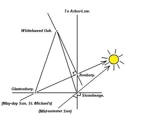
Stonehenge,
Avebury and
Glastonbury form a right angled triangle, of which
the Glastonbury-Avebury follows the azimuth of the sun on 'Beltane'.
This triangle is accurate to within 1/1000th. Glastonbury lies
exactly 1 degree east of Arbor Low.
Stonehenge is a part of the
proposed Landscape 'Decagon', centred
on Whiteleaved Oak and
discovered by John Michell.
The same geometric connections can be seen to extend outwards to other sites across Britain.
The Lundy Triangle:
The
Station-stones have been shown to have been a prominent part of the
original Stonehenge monument. They define the extremes of the moons
and suns cycles, and an association between them and the location of
the Bluestones, from which the monument was originally composed has
been determined in the shape of a Pythagorean triangle across the
landscape. Lundy Island shows activity from both the Mesolithic and
Neolithic periods (17).
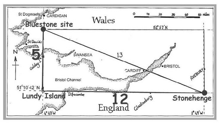
Robin Heath and
John Mitchell suggested that Stonehenge, Lundy Island and Preseli
form together to make a 5:12:13 Triangle, the second in the
Pythagorean set. The dimensions are 2,500 times the size of the
'Station Stone' rectangle. It is
particularly noticeable that the Rollrights
stone-circle is located at (51� 58′ 20″ N,
1� 34′ 19″ W), which is almost exactly
on the top right-hand corner of the rectangle, with both
Glastonbury and Avebury lying on the same alignments.
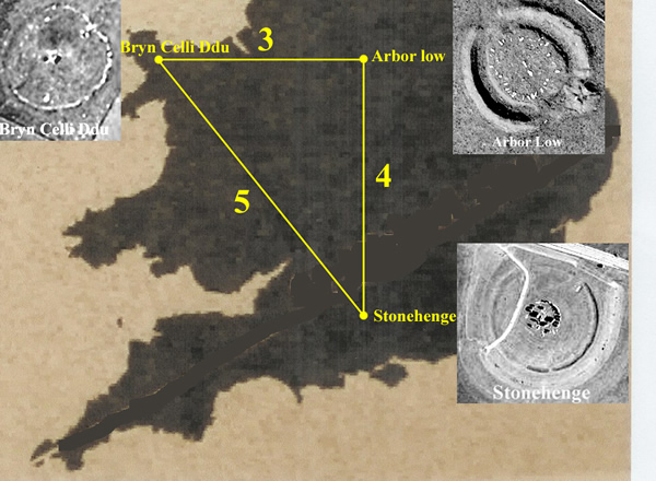
The three
Henge-circles of Stonehenge, Arbor Low
and Bryn Celli Ddu form together
to make a 3:4:5 Triangle.
(More
about English Geodesy)
|
The Geodetic
Relationship between British Complexes. |
|
Brodgar |
59�
00' 07" N |
03�
13' 43" W. |
Significant
lunar latitude (Moon rolls along horizon).
(1�
E Bryn Celli)
|
|
Maes Howe |
58�
59' 48" |
03�
11' 17" W |
|
| Callanish |
58�
12' 12" N |
06� 45' 25" W |
(7� N, 4� W
Glastonbury), (7� N, 5� W Stonehenge), (5�
N, 2.5�
W Bryn Celli) |
|
Thornborough |
54� 12' 14" N |
01� 33' 25" W |
(3�
N Stonehenge),
( 4�
S of Callanish), (1�
N Bryn Celli and Arbor Low) |
| Newgrange |
53�
41' 40" N |
06�
28' 30" W |
(2.5�
N Stonehenge),
Orientated to Avebury - 4 |
| Tara Hill |
53� 35' N
|
06�
36' W |
|
| Bryn Celli Ddu |
53� 12' 30" N.
|
04�
14' 20" W |
(5�
S, 2.5�
E Callanish), (2�
N, 1.5�
E Glastonbury) |
| Arbor Low |
53� 10' N, |
01� 46' W |
(2�
N, 1�
E Glastonbury), (5�
S, 5�
E Callanish), (2.5�
E Brynn Celli, same latitude) |
|
Rollrights |
51� 58′ 20″ N |
01� 34′ 19″ W |
(7�
S Brodgar), (5�
E Tara Hill), (Same longitude as Thornborough) |
| Avebury |
51� 25' 43'' N |
01� 51'
15" W |
(Latitude
90/7 x4),
(St. Michael's Ley) |
| Silbury
Hill |
51�
24' 56" N |
01�
51' 27" W |
(Latitude
90/7 x4),
(St. Michael's Ley)
|
| The
Sanctuary |
51�
24' 36" N |
01�
49' 54" W |
(1/4 North of Stonehenge - same longitude) |
| Stonehenge |
51� 10' 42'' N |
01� 49'
34" W |
Significant solar/lunar Latitude:
(0.25� S of Sanctuary), (7�
S, 5� E Callanish) |
| Glastonbury |
51� 09' N |
02� 45' W |
(Same latitude as Stonehenge),
(7� S, 4� E Callanish), (2�
S, 1.5�
W
Bryn Celli) |
All the sites show separation by units of
degrees
(accurate within 3' of a degree
or 95%)
(British Geodesy
Homepage)
It is common knowledge that at the very time all
this construction work was being carried out on Salisbury plains (c,
3,100 - 2,400 B),
the Mediterranean was alive with activity, with the emergence of
other cultures also beginning to build astronomically orientated buildings on an
unprecedented scale (most noticeably on Malta and in Egypt). While
there is yet any evidence of direct contact between these
Mediterranean cultures and those on the Western Atlantic, an
argument is building in favour of this very idea and similarities
between the underlying applications of geometry and astronomy (and
art) in the
constructions seems to favour this idea. Perhaps it is now worth
exploring this proposition.
The Primal Mound:
The 'World Hill' (Mount Meru) or the
'Primal Mound' is a concept that appears in several ancient
traditions (Most noticeably Indus Valley, Sumerian and Egyptian) in
which it was considered to be the centre of the physical,
metaphysical and spiritual universe. The Surya Siddhanta, one
of the earliest Hindu doctrines (siddhanta) in archeo-astronomy,
describes that Mt Meru lies in 'the middle of the Earth' ("Bhugol-madhya")
(18). Evidence of cultural
exchange between these contemporary cultures opens the way for
debate over the original symbology of the Ziggurat/Pyramid form
itself. There is plenty of room for suggestion that the Great pyramid was built as
a representation of the
Primal Mound in the Egyptian mythology of creation. The ancient
Egyptians all believed that the world had arisen out of the lifeless
waters of chaos, called Nu. They also included a
pyramid-shaped mound, called the Benben, which was the first thing
to emerge from the waters. (25)
Perhaps in Silbury hill
we see echoes of this theme, as it is now commonly accepted that it
was carved out of the surrounding chalk for exactly this reason.
Silbury hill was built in a hollow in the land alongside the
source of the River Kennet and has several blind-springs opening in
the area of its base. This results in it still being surrounded by
water for part of the year, although it is likely that it
was permanently surrounded by water when it was first built. Of all
the candidates for man-made 'primal mounds' both Silbury and the Great
pyramid are at the top of the list, being the largest examples of
their kind, and it is a curious coincidence that both have exterior
angles that mirror the others latitude.
The
theme of a combination of a prominent Mound being built beside a
stone-circle (often surrounded by water) can be
seen to be repeated at
the same time in history and across Europe and the Mediterranean,
for example: Maes-Howe in the
Orkneys, Gavrinis in France,
Boyne Valley, Ireland and
Ggigantija in Malta to name but a few.
The complex at Evora is not surrounded by water but
Zambujeira is the largest passage
mound in Europe and sits within view of one the oldest stone stone-circles
in Europe - Almendres. While this theme is
suggestive of a male-female balance in structures, it can also been
seen as an extension of the mythological 'Primal Mound'. The theme
of aligning 'Mounds' or 'Beacon Hills' is
commonly seen across Britain and beyond, with the primary example being
the St. Michael's Ley which runs across England From St. Michaels
mount in Cornwall through several distinct, natural and man-made
beacon hills
(Most noticeably Glastonbury and Silbury Hill), along the alignment with the path of
the sun on St. Michael's day (Beltane), evidence of the intrinsic
connectivity between the builders, the monuments, the landscape and
the cyclic motion of the heavens at this time.
(More about Passage
Mounds)
We have seen that two of the earliest megalithic
sites on the Salisbury complex (Stonehenge and the Sanctuary) have associations that appear to be
based on earthly measurements: Most significantly, the placement of
the Sanctuary exactly 1/4 degree north of Stonehenge, and Arbor Low
a further 1.5� north on the same
longitude. The association of other significant sites such
as Glastonbury, Bryn Celli Ddu, Callanish and the Orkneys with the same
geodetic fingerprint clearly begins to suggest a means of
calculating the longitude/latitude of one site in relation to
another. Something which even today, is not officially recognised
before the Greeks. There are however, several stubborn facts which
require answers in order to dismiss them from the possibility of
such a scheme:
Newgrange - Avebury
Newgrange was constructed c. 3,200 - 2,900 BC (Wiki), In early Irish
mythology, Newgrange was not only the alleged burial place of the
prehistoric kings of
Tara,
but also the home of a race of Irish supernatural beings, known as 'Tuatha
de Danann': The people of the goddess Danu. If the archaeology is
correct, these same people are now rather ignominiously referred to as the 'Grooved Ware' people.
Apart from being built at the same time, Newgrange shares other similarities with the
monuments at Salisbury. It is noticeable for example that the
Newgrange monument originally consisted of a stone circle beside a
cursus, as at Stonehenge. The passage mound itself is orientated
along the path of the Midwinter sun, while Stonehenge was orientated
with the Midsummer sun. These two major monument complexes are not
only situated at one one-hundredth of the earth's circumference
apart, but it has been calculated that at Avebury (when obliquity equalled precisely 24 degrees), the
level summer solstice sunset pointed precisely to Newgrange
(22). Burl
notes that the diameter of the bank at Brodgar is almost exactly 175
megalithic yards, the same as the inner circles of the Avebury and
Newgrange monuments in England and Ireland respectively.
(16)
There is another curious similarity between
Newgrange and Avebury in that original Stone circle at Newgrange had
97 stones (rather than 98 at Avebury), which suggests the
possibility of a primitive alternative to the Metonic Cycle, as 98
lunar months is the same as 8 solar years. The number 97 has
another astronomical significance, as it is a relevant number in the
calculation for leap years. We know that there are either 366 or 365
days in the solar year. The Gregorian calendar, which was designed
to subvert the necessity for adding random days repeats completely
every 146,097 days, which fill 400 solar years. Of these 400 years,
303 common years have 365 days leaving a need for 97 'leap' years,
each with 366 days. This yields a calendar mean year of exactly 365+97/400.
days = 365.2425 days.
The Orion Connection:
The Orion constellation held a fascination for many
ancient cultures and featured strongly in mythology and we can say with
a pretty good measure of confidence, that it is also associated through
the design in several prehistoric monuments. Apart from the obvious
association with the Giza pyramids, it is noticeable that there are a
large number of Triple-Henges and Stone circles in the British Isles
which appear to have the same 'Dog-leg' in the angle between them. The
most prominent of these is the three Thornborough Henges for which Prof.
Clive Ruggles has made a clear connection to Orion, both in physical
design and in orientation, but other prominent sites such as
The Hurlers and Avebury are also
suggested.
Although largely dismissed today, the third
circle at Avebury was originally discovered
in 1937 by 'A. Keiller', who found
three 'unrecorded
stone holes, eleven metres apart on the arc of a circle about 103m in
diameter, much the same as the 'North' and 'South' inner circles. The centre of this third circle was on the same
North-north-west to South-south-east axis as the others and Keiller
concluded that "it seems impossible therefore not to conclude that what
one may term as 'Avebury I' consisted of three settings of
stones...unaccompanied by banks or ditches".
Of additional interest is the dimensions of these
Henges, as there are
other Henges in UK with similar measurements. The three Henges at the
Thornborough complex are exactly double the size of Stonehenge and the
Dorchester Henge (Which lies along the St. Michael's ley). It has
been calculated that the particular circumference of Stonehenge
would allow for 1/2� of horizon every 1 MY (using a division of
366�)(26).
This means that from the centre of the Henges at Thornborough (Which
is exactly double the size), each 1� of horizon would measure 1 MY
along the flattened top of the surrounding banks.
(Orion in Prehistory)
Stonehenge-Giza.
There have been several suggestions of
similarities between Stonehenge and the Pyramids of Giza in Egypt.
Apart from the fact that they were both started at approximately the
same time, the most noticeable similarity is in the exterior angle of the
Great pyramid, the latitude of Stonehenge and the orientation of
the avenue (along the summer solstice), all of which are 51� 51', both of which
were noticed by Sir Norman Lockyer at the turn of the 20th century.
We have already seen that Avebury is located at exactly the latitude
360/7, and it seems relevant that the Giza complex is located at
latitude 360/12.
(Stonehenge lies 33� to the West of Giza - within
95% accuracy)
(Stonehenge - 1� 49′ 34.28″
W) (Great Pyramid - 31� 7′ 52″ E)
According to Peter Le Mesurier,
the Sarsen-ring (whose official inner diameter is 97ft or 1162.8
primitive inches), has a circumference of 3652.4 primitive inches, which
he suggested as indicating a knowledge of the Solar year, it is also
exactly one 'quarter-aroura', as measured in ancient Egypt
(26), and
the same dimension that was used for the top of Silbury hill.
The Quarter Aroura.
According to Peter Le Mesurier
(The Stone Measurer), the
Sarsen-ring (whose official inner diameter is 97ft or 1162.8 primitive
inches), has a circumference of 3652.4 primitive inches, which he
suggested as indicating a knowledge of the Solar year, as it is also
exactly one 'quarter-aroura',
as measured in ancient Egypt
(26)
and the same dimension as the top of Silbury Hill.
Flinders Petrie calculated the diameter at 1167.9 (+/- 0.7 British
inches) (13), which works out at 1166.6 Primitive inches (giving a
circumference of 3663.1 primitive inches), which although still accurate
to within .03%, is not as exact as Le Mesurier suggested.
It has also been calculated by
Martin Doutr�
(27) that the diameter of
the outermost perimeter of the site measures 378 ft: Exactly half of
the 756 ft that the base of the sides of the Great pyramid.
|
The Geodetic
Relationship between European Complexes. |
|
Giza |
29� 58' 45" N |
31� 08' 03" E. |
(Latitude 360/6),
(33�
East of Stonehenge). |
| Orkneys |
58�
59' 56" N |
03� 11' 20" E. |
Significant
lunar latitude (Moon 'roll's' along the
horizon)
|
| Newgrange |
53�
41' 40" N |
06�
28' 30" W |
Inter-visible with
Tara Hill, (Sacred heart of Ireland) |
| Tara Hill |
53� 35' N
|
06�
36' W |
(6�
N, 3.5�
W of Carnac),
(15� N, 1.5� E of Evora) |
| Arbor Low |
53� 10' N, |
01� 46' W |
(2�
N, 1�
E Glastonbury), (2�
N, Stonehenge) |
| Avebury |
51� 25' 43'' N |
01� 51'
15" W |
(Latitude
90/7 x4 or 360/7), (1/100th circumference from Newgrange/Tara) |
| The
Sanctuary |
51�
24' 36" N |
01�
49' 54" W |
1/4� North of Stonehenge on same
longitude. |
| Silbury
Hill |
51�
24' 56" N |
01�
51' 27" W |
(Shares mutually reciprocated latitudes and
exterior angles with Great Pyramid). |
| Stonehenge |
51� 10' 42'' N |
01� 49'
34" W |
Significant solar/lunar Latitude:
(1/4� S of Sanctuary), (2�
South Arbor Low) |
| Carnac |
47� 35' 52" N |
03� 03' 47" W |
Significant solar/lunar Latitude:
(9� N, 5� E of Evora),
(6�
S, 3.5�
E Tara Hill) |
| Evora |
38� 33′ 28″ N |
08� 03′ 41″ W
|
(Latitude 90/7 x3),
(9� S and 5� W of Carnac),
(15� S, 1.5� W of Tara Hill) |
|
Malta (Hypogeum) |
35� 52' 05" N |
14�
05' 45" E |
(6�
N, 17 W�
of Giza - only 90% accuracy) |
All the sites show separation by units of
degrees
(accurate within 3' of a degree
or 95%)
(European Megalithic
Complexes)
(Sacred
Places- The Living Landscape)
(Altered Landscapes)
(Prehistoric
British Geodesy)
(Egyptian
Geodesy)
(Geodesy
Homepage)
|