|
Location: Atacama desert, Chile. |
Grid Reference:
19�55' S, 69�38' W. |
 The Atacama Complex:
The Atacama desert
is best known as the location of the huge 'Atacama Giant', the
largest geoglyph in the world (right).
However, the Atacama desert
in Chile is also officially the oldest, driest desert in the world
(1).
Perhaps surprising then that it should also turn out to be the
location of a vast sprawling prehistoric complex unlike any other in
the Americas. Perhaps ironically, it is the historical lack of water
in the region that has preserved the remains of this incredible
discovery, which lies today, partially concealed beneath the silt of
an ancient flood
event.
'The interior
areas of the Atacama, oases and some valleys have been populated for
millennia, being the seat of the most advanced Pre-Columbian
societies found in Chile'.
(2)
The Atacama Desert
Climatology:
There are locations
in the Atacama where not a single drop of rain has ever been
recorded by humans. Researchers at Edinburgh University recently
studied dry river beds which have had no water running through them
for 120,000 years. They found loose sediment surfaces that would be
washed away by any desert rainfall and these are older than 20
million years, making the region unique on earth.
(5) For this reason, it is has
been used by NASA to test Mars vehicles. However....
In 2003, a team
of researchers published a report in the journal Science
titled "Mars-like Soils in the Atacama Desert, Chile, and the
Dry Limit of Microbial Life" in which they duplicated the
tests used by the Viking 1 and Viking 2 Mars landers to detect
life, and were unable to detect any signs in Atacama Desert
soil. (6)
(The Atacama
is home to a variety of life forms - Official cost of Viking
missions: $1 Billion dollars)
|
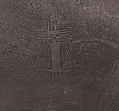
Atacama Giant: (Gigante de Atacama) |
The Atacama desert is probably most famous for
the huge petroglyph on the side of a hill called 'Cerro Unitas'.
This is the largest prehistoric anthropomorphic figure in the
world with a height of 119 metres and is suggested to represent a deity for the
local inhabitants c. 1000 to 1400 AD.
(4)
The Atacama Giant is a largest
of over 5,000 geoglyphs in the Atacama Desert, Chile.
Because of its
high altitude, dry air and nearly non-existent cloud cover, the
Atacama desert is one of the best places in the world to conduct
astronomical observations
(2), supporting the
suggestions that the Atacama Giant may have been built as a
lunar calendar for
knowing where the moon would set; from which
the day, crop cycle, and season could be determined.
The points on the top and side of the head are
suggested to show which season it would be depending on their alignment
with the moon, although as yet, there has been no
substantial proof of this supposition.
More than 5,000 geoglyphs�prehistoric works of
art placed on or worked into the landscape�have been recorded in
the Atacama Desert of northern Chile over the past thirty years.
The Chilean glyphs in the Atacama Desert are far more numerous
and varied in style, cover a much larger region (150,000 km2
versus the 250 km2 of the Nazca lines), and are currently
believed to have been constructed between
600 and 1,500 AD. Both the Nazca lines and the Atacama glyphs had
multiple symbolic or ritual purposes; while some scholars believe the
Atacama glyphs additionally had a vital role in the
transportation network connecting the great South American
civilizations.
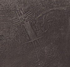
More
anthropomorphic geoglyphs lie directly south of the Atacama giant
(far left).
The Chilean
glyphs were built and refined by several South American cultures�likely
including Tiwanaku, Inca, Atacame�o as well as less-advanced groups�the widely varied
geoglyphs are in geometric, animal and human forms, and in about
fifty different types. Using artefacts and stylistic
characteristics, archaeologists believe the earliest were first
constructed during the Middle Period, beginning around 800 AD.
The big question is... Were they built before or after the decline
of the complex.
Because of its high
altitude, nearly non-existent cloud cover, dry air, and lack of
light pollution and radio interference from the very widely spaced
cities, the desert is one of the best places in the world to conduct
astronomical observations (2)
*** Full Credit is Given to Ms. Holly Ahlberg for bringing this site to our attention ***
(Contact Ms Ahlbeg:
holly@commspeed.com)
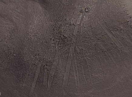
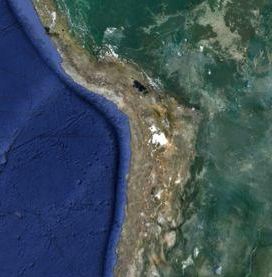
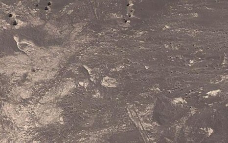
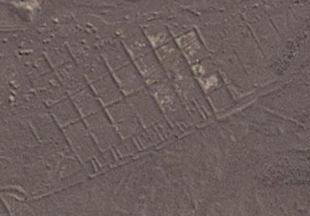
South of the Atacama Giant, and partially covered
beneath an ancient flood plain, the outline of a vast ancient complex has
been identified.
Although no housing or civil-structures have yet
been officially identified, the complex is clearly man-made and measures at least 5 miles in diameter,
so that whether is is a city, or an ancient agricultural
system, it is still the largest known of its kind in prehistoric
Chile and ranks alongside the largest man-made complexes in the Pre-Columbian
America's.
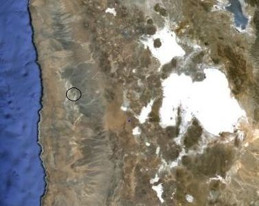
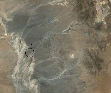
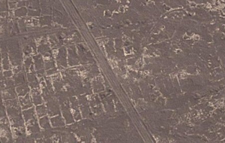
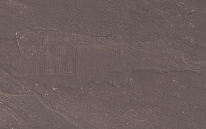
Satellite images showing the location of the
discovery. (Approx: 19�55' S, 69�38' W)
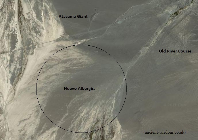
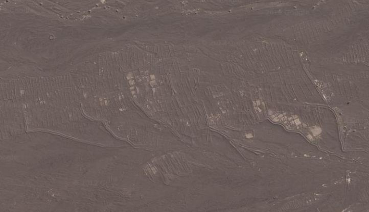
Approximate location of Nuevo Albergis: The
white sections are salt deposits, marking dried up waterways.
Apart form being
next to the largest geoglyph in the world (Other Chilean Goeglyphs
have been suggested to have been placed next to important trade
routes), it can be seen that the complex was built at the end an ancient
river system which is now essentially dried up. However, following the river bed
east, it can be seen to originate from the region of the Salar Uyuny salt lake
(approx 80 miles to the north - The large white object in the middle pictures, above). It is a
reasonable to assume therefore that the complex was in operation at a time when
this was a living lake, which would have supplied the area with all
its water needs. Presumably, at some time in the distant past, when
the lake was still filled with water, it would have flooding down onto the flatlands
(seasonally?), engulfing
different parts of the region in the process. If this was an agricultural
operation, the annual flooding would have changed the course of the
rivers, depositing large amounts of nutrient-rich silt in the
process, a process which would have been invaluable to large-scale
agriculture. The suggestion that the nearby 'Atacama Giant' was
built as a lunar calendar to predict the seasons, supports the idea
that parts (at least) of the complex were built for agriculture.
This discovery was first noted by
Ms. Holly Ahlberg (Nov, 2012) from whom the
inspiration for this article came. At present, and following several e-mails to
archaeologists and academics, there has been no reply concerning this discovery.
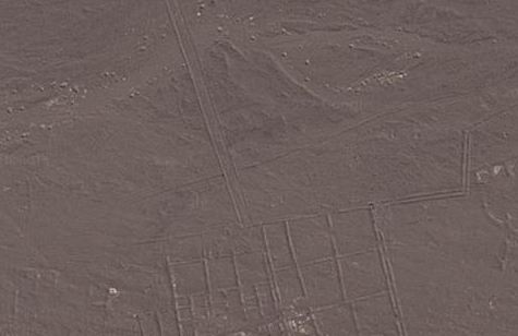
The following images are taken from Google, and clearly show a vast
and incredibly well laid out grid-network of fields and/or possible housing.
Other structures such as canals, roads and civil
structures have been tentatively identified.
Images of
'Nuevo Albergis'.
(All these images
are easily visible in the highest definition on GoogleEarth)
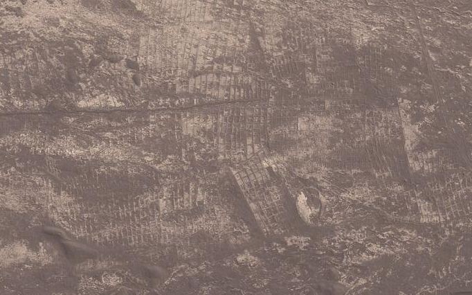
Section of the neatly aligned
grid-layout of the complex.
The vast network of grid-aligned
plots extends for miles.
These pictures only
show the smallest fraction of what what can be seen to have once
been a vast complex extending out in the flood plain for several
miles, consisting primarily of (several) thousands of similar plots,
tightly grouped and laid out in neat grid formations. It is clear
that whoever built these structures, they were well organised and
the complex must have been of great significance when it was in
operation.
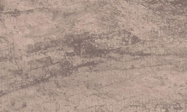
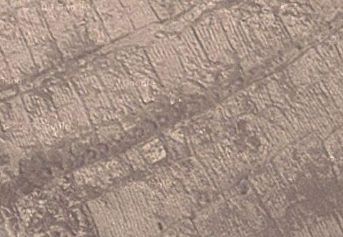
From what can be
seen on Google-earth, it appears that many of the constructions lie
beneath silt deposits, whilst others were built over pre-existing
deposits, suggesting that what we are looking at is a complex that
was built in several phases separated by different flood events,
and/or over a period of time. The presence of numerous 'canals'
leading to the structures highlights the possibility that it was
built where it was because of the availability of water
running from the now dried up Salar Uyuny salt flats (Once a
freshwater lake and over 80 miles away).

The observation
by Ms. Ahlberg, of the similarity in appearance between the
areas of the site and modern salt-beds, certainly seems very
credible in light of the environmental conditions, high salt
content from the lake (particularly at the end of its life) and
the location of the site in relation to the Inca highways, and
by the sea - both of importance to a large-scale industrial
operation.
The Road to Nuevo
Albergis:
One road in
particular appears significant. The road, which is approximately
30ft wide and with 4ft high banks on either side, runs from the
Atacama giant straight to the heart of the complex. This road is
connected at its northern end to Route 15, now tarmacked and
constructed over an existing (Inca?) route which leads 150 miles
directly east to Orouro in Bolivia. By following the road south to
the heart of the complex, several significant facts emerge:
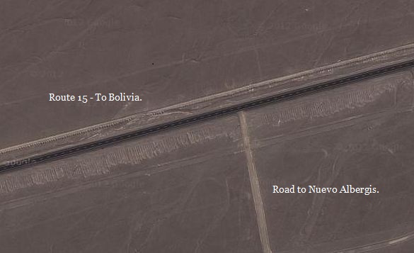
The Road to Nuevo
Albergis: Northern end, junction of Road to Bolivia. (The 'Atacama
giant' lies just to the North).
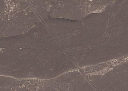
The road was
built over an ancient river bed (left), and was submerged by a
different flood event (right).
The same road was
built over parts of the complex (left), and leads to contemporary
structures (right).
Whilst the greater
number of enclosures appear laid out in a grid-like checker-board
fashion, perhaps more suggestive of a farming system (similar to
paddy-fields), without roads, entrances or other features expected
from dwellings, there are other structures visible which are more
suggestive of housing and/or civil structures as the following
images show:
Areas of the
complex showing evidence of what appears to be an agricultural
imprint.
A walled section
of the complex built on higher ground, and partially washed
away by river erosion.
The presence of
what appears to be walled canals leading from the surrounding
riverbeds.
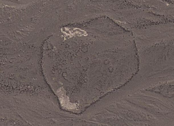
An enclosure
surrounded by a protective stone walls with circular markings
inside. The Atacameno people built circular, honeycombed
dwellings as seen at the Archaeological village of Tulor.
Some of the
structures have what appears to be evidence of walls and
entrances between plots.
Who Built It... Possible Candidates.
Evidence for occupation at
nearby San Pedro begins surprisingly at around 11,000 years ago;
It is currently believed that bands of
hunter-gatherers lived along the Atacama
coastline from 11,000 BC to 500 BC, with
the first fishing settlements appearing around
5,000 BC, and Tiwanaku artefacts appearing at
about 700 AD.
The Chinchorro, who lived in
fishing settlements along the coast at that time, would have
flourished under these relatively benign conditions. By combining
460 dates from 131 archaeological sites in the Atacama with existing
data on how hunter-gather populations fluctuated elsewhere, the
researchers developed a model which indicates that the Chinchorro
experienced a hike in population density between 5,000�3,000 BC.
(3)
The Chinchorro however, did not practice agriculture, with the
possible exception of growing reeds for mats and fiber. They used
the products of their environment pelican beaks and feathers,
seashells, sea lion hides, and even whalebone for practically all
their needs. Some use of feathers and llama woo have been found,
which would indicate the coastal Chinchorro traded with the
inhabitants of the Andean highlands.
(6)
Around 2,000-1,000 BC, the Atacame�o people fully
adopted the sedentary culture. At this stage, they
had an economy mainly based on llama breeding and
maize agriculture. Between 400 BC and 100 AD, Atacame�o
farming reached a peak in its development.
(1) As such, this is the most
likely candidate for such a large scale operation of farming.
However,
regional climate records for the time, based on the periodic
appearance of certain plants in the rock records, indicate that
there was a period of greater rainfall across the Andes above the
Atacama between 5,800 BC and 4,700 BC, which would have charged
groundwater reserves in the usually dry desert of northern Chile and
southern Peru.
The
Atacameno settlement of Tulor is one of the
oldest and best-preserved Neolithic villages in South America.
The architecture of the time had
circular clay buildings, joined together, and with patios and
passageways that communicated with one another. The rooms, whose
foundations were set up on previously excavated grooves, were built
in adobe in an arched form that reached a height of almost 2 meters,
and finished off in a conical roof held by wooden poles.
(7) They
bear no resemblance however to the Nuevo Albergis structures.
The nearby archaeological site of San Pedro de Atacama
is a Tiwanaku Empire outpost, located in a
desert oasis some 800 kilometres from the
capital of the Tiwanaku empire, and at 2,430
meters above sea level in the foothills of the
Andes mountains in the Atacama desert of extreme
northern Chile. Whilst this appears to be a
completely different system of agriculture to the Tiahuanacans,
(who preferred to use the raised-bed systems), the sheer scale of
the operation suggests that it was both important and likely fed
thousands of people, more than could be accounted for in this
otherwise dry desert region of Chile. Perhaps what we are looking at
here is a regional 'wholesale' supplier of food to one of the larger
cultures such as the Tiahuanacan or Inca empires.
*** Full Credit is Given to Ms. Holly Ahlberg for bringing this site to our attention ***
(Contact Ms Ahlbeg:
holly@commspeed.com)
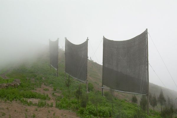
And Finally: The Chilean Fog Catchers:
Although rain rarely
falls on the Atacama's coastline, a dense fog known as camanchaca is abundant. The fog nourishes plant communities
called lomas, isolated islands of vegetation that can
contain a wide variety of species, from cactuses to ferns. The
success of the cheap Chilean fog-catchers has inspired people in
countries such as Peru, Ecuador, South Africa, and Namibia to
develop similar systems for their arid-land homes.
For more information
on the innovative art of fog-catching, go to
www.idrc.ca/nayudamma/fogcatc_72e.html.
(Pre-Columbian
America Homepage)
(List
of Pre-Columbian Sites)
|