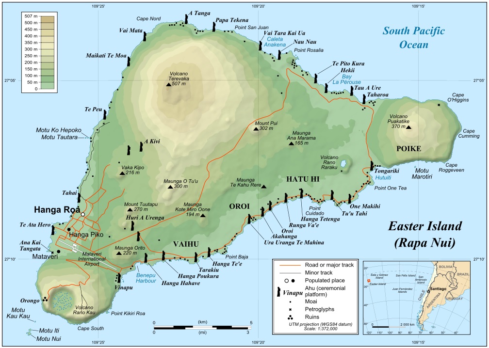
|
Location:
Easter Island, Pacific Ocean. |
Grid Reference:
27�
8' 24" S, 109� 20' W |
 Easter Island:
('Big Island',
'The navel of the Earth', 'The eye turned to the sky').
Easter Island:
('Big Island',
'The navel of the Earth', 'The eye turned to the sky').
Easter Island is situated in the middle of the Pacific
Ocean, and was one of the primary islands of the Polynesian Island group.
Hundreds of stone statues or 'Maoi' lie scattered around the island, and
encircle it on long raised platforms. The island poses several questions
in regards pre-Columbian contact with the Americas.
The small, isolated nature of the island led many to
suggest that this may have led to the eventual implosion of tribal
activity on the island, which culminated only shortly before its discovery
by the Dutch in 1772. Recent studies however suggest that the islanders
were masters of their environment and the collapse actually occurred
'following' European contact.
(7)
There have been several suggestions of an origin and
contact from both sides of the Atlantic.
(Click
here for Map of Island)
|
Easter Island: (Rapa Nui). |
The island was 'discovered' on
Easter sunday (April 5th), and was therefore named Easter island. Before this, it
had been called 'Rapa Nui' - (Big Island), 'Matakiterani'
(Eye turned to the sky), and 'Te Pito No Te Henua' (The Navel of the
Earth). (1)
A Brief History. The reigning
consensus is that Easter Island was colonized around 300-400 AD as part of
an eastward migratory trend that originated in Southeast Asia around 2000
BC. The settlers are thought to have been Polynesians from the Marquesas
Islands, 3600 km northwest, or the Mangareva (Gambier) Islands, 2500 km
west.
(4)
The large separation of Easter Island from any other inhabited
island has led historians to believe that their arrival was an accidental
and once only event. This view is strongly contested, in light of other
known examples of Polynesian feats of navigation, and the several various
cultural influences seen in the iconography of the island.
The earliest
Radio-carbon date so far from the island is 380 AD, from
Thor Hyerdahl's expedition. (1)
The island was officially discovered
in 1722 by a Dutch expedition under Admiral Jacob Roggeveen.
Like
subsequent European visitors, the Dutch reported seeing not only
fair-skinned Polynesians, but people of darker skin, others who
were white like Europeans, and a few with reddish skin.(4)
In 1770 a Spanish party
from Peru claimed the island for Spain. A conflict seems to have raged
on the island before the arrival of the British navigator Captain James
Cook four years later. He found a decimated, poverty-stricken
population, and observed that the statue cult seemed to have ended, as
most of the statues had been pulled down. It�s possible that some of the
statues were toppled even before the Dutch and Spanish visits but that
those sailors did not visit the same sites as Cook.
The Frenchman La
P�rouse visited Easter Island in 1786 and found the population calm and
prosperous, suggesting a quick recovery from any catastrophe. In 1804 a
Russian visitor reported that at least 20 statues were still standing.
Accounts from subsequent years suggest another period of destruction so
that perhaps only a handful of statues were still standing a decade
later. Some of the statues still upright at the beginning of the 19th
century were knocked down by western expeditions.
Chronology:
380 AD - Thor Hyerdahl's earliest
uncorrected C-14 date from Easter Island. (1)
690 AD (+/- 130) - William Mulloy's
earliest uncorrected C-14 date from Easter Island. (1)
907-957 AD (+/1
200) - Earliest Ahu with Solar orientation according
to William Mulloy. (1)
1772 - Island first 'officially' discovered on Easter
Sunday by Dutch.
1862 - Peruvian slavers took 1,000 men
(Most of the male population), to work the Guano Islands of Lima. 100
survivors were later returned, of which 15 reached their homes (carrying
smallpox), which almost finished the population of the island.
(1)
1864 - Total remaining island population
- 111. (originally
estimated at 5,000).
Article:
New Scientist. 'Early Americans Helped Colonise Easter Island'.
(2011).
South
Americans helped colonise Easter Island
centuries before Europeans reached it. Clear
genetic evidence has, for the first time,
given support to elements of this
controversial theory showing that while the
remote island was mostly colonised from the
west, there was also some influx of people
from the Americas.
Easter
Island is the easternmost island of
Polynesia, the scattering of islands that
stretches across the Pacific. It is also one
of the most remote inhabited islands in the
world.
So how
did it come to be inhabited in the first
place? Genetics, archaeology and linguistics
all show that as a whole, Polynesia was
colonised from Asia, probably from around
Taiwan. The various lines of evidence
suggest people began migrating east around
5500 years ago, reached Polynesia 2500 years
later, before finally gaining Easter Island
after another 1500 years.
But the
Norwegian adventurer Thor Heyerdahl thought
otherwise. In the mid-20th century, he
claimed that the famous Easter Island
statues were similar to those at Tiahuanaco
at Lake Titicaca in Bolivia, so people from
South America must have travelled west
across the Pacific to Polynesia. His famous
Kon-Tiki expedition, in which he sailed a
balsa wood raft from Peru to the Tuamotu
islands of French Polynesia, showed that the
trip could have been made. But if it was
made, no trace remained.
Now
Erik Thorsby of the University of Oslo in
Norway has found clear evidence to support
elements of Heyerdahl�s hypothesis. In 1971
and 2008 he collected blood samples from
Easter Islanders whose ancestors had not
interbred with Europeans and other visitors
to the island.
Thorsby
looked at the HLA genes, which vary greatly
from person to person. Most of the
islanders� HLA genes were Polynesian, but a
few of them also carried HLA genes only
previously found in Native American
populations.
Genetic shuffling:
Because most of Thorsby�s
volunteers came from one extended family, he
was able to work out when the HLA genes
entered their lineage. The most probable
first known carrier was a woman named Maria
Aquala, born in 1846. Crucially, that was
before the slave traders arrived in the
1860s and began interbreeding with the
islanders.
But the
genes may have been around for longer than
that. Thorsby found that in some cases the
Polynesian and American HLA genes were
shuffled together, the result of a process
known �recombination�. This is rare in HLA
genes, meaning the American genes would need
to be around for a certain amount of time
for it to happen. Thorsby can�t put a
precise date on it, but says it is likely
that Americans reached Easter Island before
it was �discovered� by Europeans in 1722.
Thorsby
says there may have been a Kon-Tiki-style
voyage from South America to Polynesia.
Alternatively, Polynesians may have
travelled east to South America, and then
returned. There is already evidence for
that: chicken bones found in Chile turned
out to be Polynesian, so we know that the
eastward journey did happen at some stage.
However, Thorsby�s findings don�t mean that
Heyerdahl�s ideas have been vindicated. The
first settlers to Polynesia came from Asia,
and they made the biggest contribution to
the population. �Heyerdahl was wrong,�
Thorsby says, �but not completely.�
(Article:
New Scientist)
Tradition and Myth:
The French ethnologist, Francis
Maziere, went to Easter Island in 1963, a few years after Thor Hyerdahl. The
emphasis of his research focused on the almost-lost traditions of the
islanders concerning their origins. According to Maziere, the legends of
settlement of the islands by Polynesians contained allusions to
catastrophism. For example, one legend says "King Hotu-Matua's country
was called Maori, and it was on the continent of Hiva...The king saw that
the land was slowly sinking in the sea", as a result he put all his
people into two giant canoes and sailed East to Easter Island.
Another legend says that Easter Island was once 'part of a larger country
broken up by Uoke because of the sins of its people'.
(1)
|
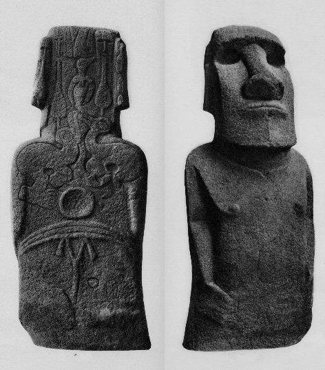
The Monuments of Easter Island:
|
The principal stone monuments on
Easter Island are ceremonial paths with paved borders, tumuli, pakeopa
(or ahu), and, finally, the great stone statues or 'Maoi'.
The 'Maoi'
- (The Stone
Statues).
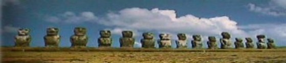
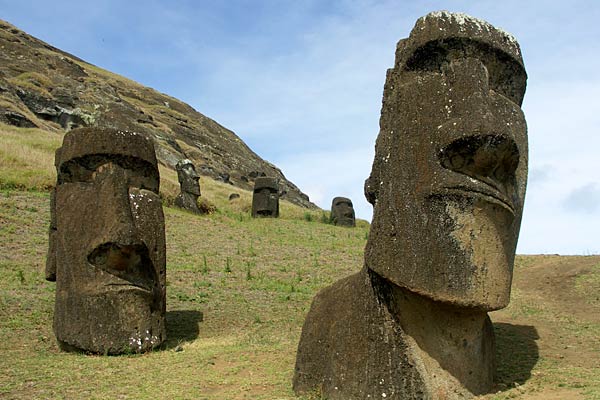
Easter Island is perhaps best
known for its immense stone statues 'Moai', of which there are
approximately 900 scattered across the island. Some of the Maoi were placed,
facing towards the centre of the island, on platforms called 'Ahu', built
along the coasts. Captain Cook was told
in 1774 that they were monuments to earlier 'ariki's', or royalty. The 'Maoi' are
also described in local tradition as having once
possessed 'mana' or a beneficial power.
All Easter Island�s giant statues
were supposedly made within the space of a few hundred years. Different
phases are clearly discernible, and may be separated by far longer
periods than orthodox opinion allows. It is significant that the statues
do not bear the slightest resemblance to the Polynesians, and in terms
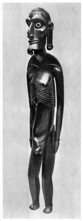
of size, appearance, and number are unique in the Pacific.
All the giant statues on Easter Island
have long ears, and some islanders still practised ear elongation at the
time the first Europeans arrived. The custom was also practised in the
Marquesas Islands in Polynesia, and in Peru; the Incas said they had
inherited the custom from their divine ancestors. The oldest known
practice of ear extension was among the mariners in the prehistoric
Indus Valley harbour-city of Lothal, where large numbers of big earplugs
of the type used in ancient Mexico, Peru, and Easter Island have been
found. Hindu rulers subsequently adopted the custom, but it was
restricted to members of the royal families and images of the Hindu
gods. Buddha images with long ears are found all over Asia, and
long-eared stone statues have also been dug up in the Maldives in the
Indian Ocean.
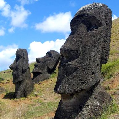
Hundreds of
Maoi are still to be found scattered
lying around the island, raising the question of why there are just so many,
with more on the way..
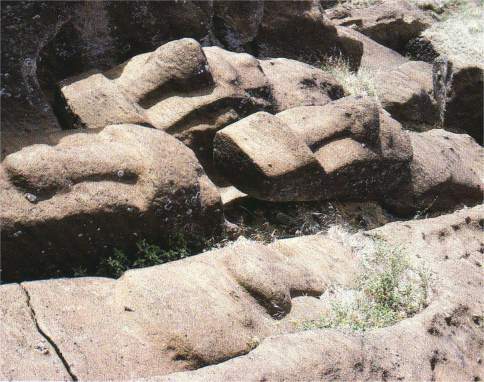
Numerous half-finished heads also lie abandoned in the
Rano Raraki quarry - as if left suddenly, mid-work.
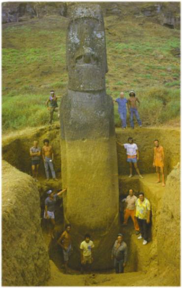
The huge heads were discovered to have bodies beneath the ground
which are controversially argued to have become naturally buried over time.
This argument is contested by the fact that they were made with more pointed
bottom parts and were placed upright in groups, all facing away from the
volcanic quarry (in contrast to the way they all once faced inwards on the
Ahu
platforms).
The buried parts of the
statues, uncovered for the first time by S. Routledge, are of great interest
not only because they add to the dimensions of these already huge statues
but also because they reveal unsuspected but particularly detailed
decorative carving (having been protected from the corrosive effects of the
air and the rain).
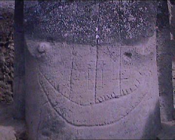
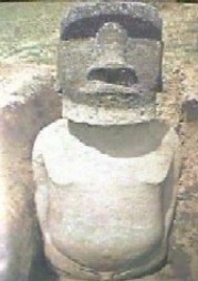
This buried Maoi was found to
have a 'sailing' vessel carved onto it.
There is said to be a distinct difference
between the statues at Rano Raraku and those on the Ahu which is that
the statues at the crater have a pointed base, destined to be buried in the
ground, while those on the ahu have a flat base, so that they can
stand on these monuments. This finding is disputed by Heyerdahl
(6), who
states categorically that following an examination of hundreds of statues,
only one has ever been found with a pointed bottom, and that he believes,
was because it was faulty. his contention is that they were all destined to
eventually encircle the whole island on Ahu.
The statues at the crater are
scattered around in a random manner, whereas the statues at the ahu,
when they were still standing, were perfectly aligned and in a group.
Although the giant statues appear scattered haphazardly, they actually form
three major groups on the inner slope of the crater, facing north, such that
they all have their backs to the face of the volcanic rock from which they
were carved.
|
Moai Statistics.
The following statistics on
Easter Island's moai are the results of Van Tilburg's survey in 1989.
She reported, "A total of 887 monolithic statues has been located by the
survey to date on Easter Island...397 are still in situ in quarries at
the Rano Raraku central production centre.....Fully 288 statues (32% of
887) were successfully transported to a variety of image ahu
locations....Another 92 are recorded as "in transport," 47 of these
lying in various positions on prepared roads or tracks outside the Rano
Raraku zone."
- Total number of moai on Easter Island: 887
- Total number of maoi that were successfully
transported to their final ahu locations: 288 (32% of 887)
- Total number of moai still in the Rano
Raraku quarry: 397 (45%)
- Total number of moai lying 'in transit'
outside of the Rano Raraku quarry: 92 (10%)
Less than one third of all
carved moai actually made it to a final ceremonial ahu site. Was this
due to the inherent difficulties in transporting them? Were the ones
that remain in the quarry (45%) deemed culturally unworthy of transport?
Were they originally intended to remain in place on the quarry slopes?
Or had the islanders run out of the resources necessary to complete the
Herculean task of carving and moving the moai?
The Size and Weight of Moai.
Measuring the size, weight, and shape of the
887 moai on Easter Island has been a 15-year process for Van Tilburg.
The most notable statues are listed below:
- Largest moai:
Location: Rano Raraku Quarry, named "El Gigante"
Height: 71.93 feet, (21.60 meters)
Weight: approximately 145-165 tons (160-182 metric tons)
- Largest moai once erect:
Location: Ahu Te Pito Kura, Named "Paro"
Height: 32.63 feet (9.80 meters)
Weight: approximately 82 tons (74.39 metric tons)
Largest moai fallen
while being erected:
Location: Ahu Hanga Te Tenga
Height: 33.10 feet (9.94 meters)
(Ref: http://www.pbs.org/wgbh/nova/easter) |
There were clearly some very large stones
carved on this island, and a lthough
Charles Berlitz estimates the largest carved stone (still unfinished), at
approximately 400 tonnes (3),
this figure is greatly reduced by
D. Zink
(1), who estimates the largest 'Moai' on the island at 90
tons (length 90ft, still in quarry). Whether the two are talking about the
same object or not is difficult to say, assuming they are however, this
disparity illustrates how much estimates can vary from one source to
another.
(The
Top-50 Megaliths of all Time)
Detailed information about the
Maoi:
(The Easter
Island Statue Project)
The 'Eye turned to the sky'.
When proof was found in 1978 that
some of the Easter Island statues once had inlaid eyes, it came as a
shock to many researchers, who had opposed the idea on the grounds
that this was not a Polynesian custom. Inlaid eyes were a common
feature of many of the oldest images of the Middle East, from Egypt to
the Indus Valley. The seafaring Hittites, for example, adopted the
practice from the Sumerians. Many prehistoric American stone statues
also had inlaid eyes.
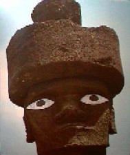
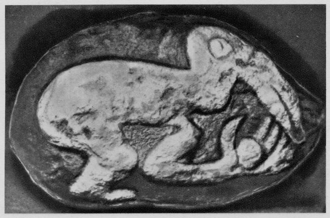
Stone top-knots or 'Pukao', and
eyes made from obsidian and cowry shells
bring the statues placed on the 'Ahu' alive. The top-knot (Right),
comes from the Isla Zapatera in Nicaragua.
|
The Ahu Platforms.
There are over 300 stone platforms or Ahu on the
island (4), many of them built from huge
cyclopean blocks, with similarities to south American structures.
The finest platform masonry, such as
that found at Ahu Tahiri (one of the two ahu at Vinapu), consists of
�enormous squared and tooled stones, that turn the edge of the toughest
modern steel�. The best facade slabs commonly
weigh 2 or 3 tons. At Vinapu one of the polished basalt slabs measures
2.5 by 1.7 m (8 by 5.5 ft) and weighs 6 or 7 tons, while one at Ahu Vai
Mata is 3 by 2 m (10 by 6 ft), and weighs 9 or 10 tons.
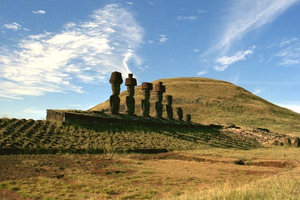
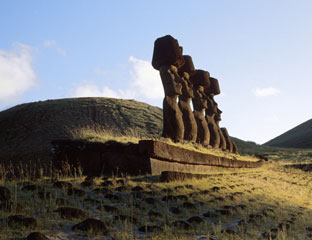
The cyclopean masonry of Ahu Vinapu
and certain other platforms is reminiscent of that of �Incan� (or
rather pre-Incan) monuments to be found at
Cuzco, Sacsayhuaman,
Ollantaytambo,
Machu Picchu, and Sillustani - All in
Peru.
John Macmillan Brown writes:
The colossal blocks are tooled
and cut so as to fit each other. In the Ahu Vinapu and in the
fragment of the ahu
near Hangaroa beach the stones are as colossal as in the old Temple
of the Sun in Cuzco, they are as carefully tooled, and the
irregularities of their sides that have to come together are so cut
that the two faces exactly fit into each other. These blocks are too
huge to have been shifted frequently to let the mason find out
whether they fitted or not. They must have been cut and tooled to
exact measurement or plan. There is no evidence of chipping after
they have been laid. Every angle and projection must have been
measured with scientific precision before the stones were nearing
their finish.
Archaeo-Astronomy:
'A hint of the existence of a solar cult on
Easter Island was found by Hyerdahl in the local name of a cave in which local
maidens were once isolated to bleach their skin for certain sacred festivals.
This cave, the cave of the white virgin, was also known as "An o keke",
or "cave of the sun's inclination". Later, a system of holes bored in the rock
at the Orongo ruins was found to indicate the summer solstice (Dec. 21st in the
southern hemisphere)...Later, Dr. William Mulloy found that the Vinapu platform
was orientated at right angles to the summer solstice sunrise. Dr. Mulloy
published a corrected C-14 date of 907-957 AD (+/1 200 years), for the earliest
ahu (or temple platform) with a solar orientation'.
(1)
Around 20 Ahu appear to have been
oriented astronomically, so that the moai faced the rising or setting
sun at the solstices or equinoxes. The inland ahu with astronomical
orientation are generally linked with the solstices, especially the
winter solstice, though the moai of Ahu Akivi face the setting sun at
the equinoxes. Astronomically oriented ahu along the coast tend to be
positioned so that the moai look straight east or west. This is true of
Ahu Tahiri (Vinapu 1), whereas Ahu Vinapu 2 marks the summer solstice.
(5)
The Navel of the Navel:
Easter Island.
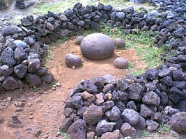 It is an
interesting fact that the islanders of Easter Island worship a
mysterious site with 5 stone spheres; in the centre of a round
stone-enclosure is a bigger stone sphere with 4 smaller stone
spheres surrounding it. The site, "Te pito kura" must have been a ritual
centre for the earliest islanders to pray and divine for something. The
stone sphere on Easter Isle is at the northern coastal area of the
island, just north of the statue quarry at the volcanic crater of Rano Raraku. It is an
interesting fact that the islanders of Easter Island worship a
mysterious site with 5 stone spheres; in the centre of a round
stone-enclosure is a bigger stone sphere with 4 smaller stone
spheres surrounding it. The site, "Te pito kura" must have been a ritual
centre for the earliest islanders to pray and divine for something. The
stone sphere on Easter Isle is at the northern coastal area of the
island, just north of the statue quarry at the volcanic crater of Rano Raraku.
The islanders have
a legend that the statues were moved to the platforms and raised
upright by the use of mana, or mind power. Either
the god Makemake, or priests or chiefs commanded them to walk
or to float through the air, and according to one legend, use was
made of a finely crafted stone sphere, 75 cm (2.5 ft) in diameter,
called te pito kura (�the golden navel� or �the navel of
light�), to focus the mana.
The Rapa Nui term
"Te Pito Kura" translates to "Golden Navel", or "Navel of Light",
while "Te Pito Te Henua" translates to "Navel of the World"; which
is what Rapa Nui is often referred to by its residents, referencing
its place in Polynesian mythology. This specific site is the
navel of the navel, as it were, located on the island's shore
near Anakena, the spot where Rapa Nui's legendary founding figure,
Hotu Matura, is said to have landed. Stone barriers surround a
worked stone sphere (the "navel" itself) measuring some 75
centimetres in diameter, reputedly brought by Hotu Matura from
overseas. Geological sourcing, however, indicates the sphere is
actually of local origin.
(The
Costa Rica Stone Balls - Petrospheres)
|
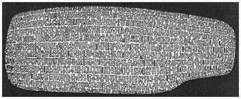
Kohua Rongo-Rongo: (Easter Island Script).
Easter island is diametrically opposite the Indus-Valley city of
Mohenjo-Dharo (Pakistan). It's name proclaims it as an earth Navel,
which some authors have suggested is because of this very fact.
It has been noted in the past that the Indus valley script shares many
similar symbols to 'Rongo-Rongo'.
(Comparison
Between the Indus Valley - Easter island Script)
The incised written tablets termed 'rongo-rongo'
were found suspended from the roof in every hut on the arrival of the first
missionary (6). On his order,
the majority were burnt, while others were hidden away in secret family
caves where they deteriorated and perished. Very few have survived today.
It was clearly documented by early
missionaries that even the most intelligent and well informed islanders
could provide the meaning for any of the signs or provide ideograms for the
simplest of words. The following quotes come from Hyerdahl's excellent
treaty on 'Early Man and The Ocean' (6):
'They knew each tablet to represent a
specific text, but disagreed about which text belonged to which tablet. If
one tablet was substituted for another in the middle of their recital, the
continued the original text uninterruptedly. The text was recited with
singing rather than speaking voice. They piously copied the original old
tablets on new boards, and regarded them as magic objects of the greatest
value'
Although there were several claims that
the script had been deciphered, none have proven worthy of scrutiny. Script
itself is a non-Polynesian characteristic and the search for its origin was
eventually rewarded through one of its paricular characteristics, which is
that it is 'arranged in boustrophedon, i.e. in a continuous serpentine band
where every second line is turned upside-down. Europeans, Chinese and the
Indus Valley people never wrote in
boustrophedon, and the language had been forgotten by the time of the
Europeans first arrival. In fact, the only place in the world where this
particular style of writing can be found is in South America; Peru to be
precise
(6). Heine-Geldern also noted a south
American provenance, said of it:
'The Cunas (of the
modern Republic of Panama) today generally write on paper. But beside this,
written wooden tablets also exist, and the Cuna's say that these were the
original writing material. The tablets seen by Nordenskiold were intended to
be hung up in the houses during celebrations. The ideograms are painted on
with colours...Also the writing is in boustrophedon, and with the succession
of lines running upwards from the bottom'
(6)
The Cuna signs however,
although continued in boustrophedon, are not upside-down on each alternate
line, and are individually dissimilar to the Easter island signs. The Easter
islanders themselves are specific in their tradition of the first immigrant
king, Hotu Matua, having brought with him sixty-seven written tablets when
he came from his home in the far-east. Heyerdahl mentions that on the
arrival of the Europeans, the Indians of Lake Titicaca area still 'continued
a primitive form of picture writing'
(6). This
conforms with the observation by Russian rongo-rongo expert J. V. Knorozov,
that the only two places where 'reversed boustrophedon' occur in the world
are Easter Island and ancient Peru.
Sariemento Gamboa, upon consulting as
assembly of forty-two learned Inca historians recorded the following in
reference to the ninth Inca 'Patchacuti Inca Yupanqui':
'...after he had well ascertained the
most notable of their ancient histories he had it all painted after its
order on large boards, and he placed them in the house of the sun, where the
said boards, which were garnished with gold, would be like our libraries,
and he appointed learned men who could understand and explain them...'
(6)
(List
and Description of all known Rongorongo Texts)
|
| The 'Cult of the
Bird-Man':
(Tangatu Mana). |
The entire social life of the Easter islanders used
to revolve around the Bird Cult (manutara: the good-luck
bird). Moreover, of all the traditions and customs this cult was the
last to disappear. The main ceremony every year was organized with
the goal of choosing the chief (the chief warrior, in particular),
who was called the tangata manu (literally, Man Bird). The
man who became tangata manu was the first one to find an egg
laid by a migrating sea bird with a long beak, the sooty tern or sea
swallow.
Tangatu Mana; The Bird-Man.
The islanders had chosen, for this competition and
the accompanying ceremony, the southernmost promontory on the
island, where the Kau or Kao volcano (Rano Kau) is located. This
crater is 1,300 meters high and approximately three-quarters of a
mile in diameter, 198 and there is a small lake,
surrounded by grasses and bushes, at the bottom of the crater. On
the side of the crater that faces the interior of the island, the
slope is quite gentle while, on the other side, the crater forms
steep cliffs of more than 400 feet in height 199 that are
battered by ocean waves. It is the most impressive site on the
island both because of its beauty and because of the silence that
reigns there, broken only by the noise of the crashing waves and the
strident cries of the sea birds as they hover near their nests on
the cliffs.
The owner of the egg, henceforth protected by the
gods, became tangata manu or man-bird 210.
Unlike the kings, who were not allowed to cut their hair, he had to
shave his head and dye his pate red. Then he had to put on a
wig-like crown made of human hair, called a hau oho, and
paint his face red and black. He had to hang a bird on his back 211
and, finally, he had to change his name, with his new name
designating the year that would follow 212.
Thus, Mrs. Routledge was able to establish a list of 86 years of
different birdmen (and the names of the victorious hopu).
Immediately after the transfer of power, via the egg, the news was
announced by lighting a fire on the summit of Rano Kau on the east
or west side, depending on the region of the island from which the
victor had come. It is possible, as suggested by S. Routledge, that
the next thing that happened was the carving on one of the rocks at
Orongo of an image of the birdman who had just been chosen and that
this practice explains the more than 111 representations of
tangata manu that are found there (as well as many that have
been erased; see Addendum). The fact that three of these sculptures
represent a tangata manu holding an egg in his hand seems to
support this hypothesis.
On the side of the volcanic crater that faces the
sea, there is a little village called Orongo, which consists of
about fifty dwellings. These dwellings were located among the rocks,
many of which were carved. The carvings most often represented a man
with the head of a bird and Mrs. Routledge reported 111 such images.
It is interesting that she also noticed that some of the carvings
were partly hidden by the walls of houses and she suggested that the
carvings had been made before the houses had been built.
The most beautiful and the most venerated idol of the
ancient islanders, known as Hoa hakanana ia or the �Breaker
of Waves", was located in one of these houses. This statue is very
finely carved and its back is decorated with beautifully carved
motifs (Click here for larger image). These motifs were not only
carved but were also accented by red paint the statue�s white
background. On each side of this statue, at its feet, there was
originally a large stone, with a hole similar to those carved in the
stones in which house supports were inserted. One of these stones
was also decorated with a crude carving. (Extract From Chavin)
The most venerated 'Breaker of Waves'.
In addition to
all the sailors from the ship Topaze, 300 natives had
been needed to uproot this statue and take it down to the dock
at Cook Bay.
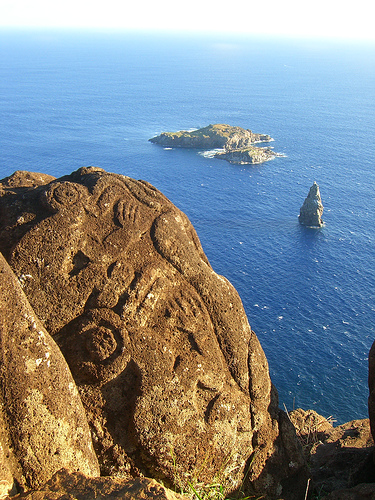
The 'bird-men' petroglyphs, which how
strong similarities to S. American Olmec rock-art.
| A Case for South
American Contact: |
Some plants on Easter Island clearly come from South
America, such as the islanders� staple food the sweet potato (which
is known by its Quechua name kumara), and also manioc and
gourd. Similarly, two species of freshwater plants, found in Easter
Island�s crater lakes but nowhere else in the Pacific, and both
useful to man, come from South America. One of them was the totora
reed, which dominated the banks of South America�s Lake Titicaca and
was cultivated in vast irrigated fields in the desert valleys on the
coast below; it was used for making mats, houses, and boats. The
other was known to the islanders as tavari, and was used as
a medicinal plant. Like the totora, it grew in Lake Titicaca. This
last information supports the case for contact with Tiahuanaco.
Balfour proposed that the stone statues on Easter
Island were directly related (in terms of style) to the statuary on
the Solomon Islands (above), but other similarities in tribal art
have been noticed in certain punum�r� masks from New
Caledonia and certain statues on Treasury Island (2).
A photo of the cyclopean platforms
'Ahu' upon
which finished figures were placed. The extreme reminiscence with south
America masonry in particular the superb multi-facetted work with 'Basalt'
rock, and the insertion of perfectly made 'filler' stones (see centre), make
a strong case for contact.
(Similar Examples
of Masonry Techniques from South America)
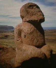
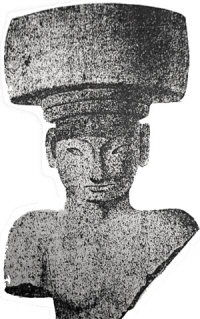
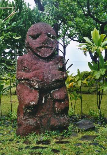
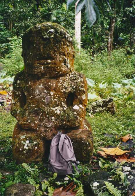
This kneeling figure from Easter
Island (left) bears a
strong resemblance to others found at La Paz,
(centre), San Lorenzo (right), and also at
Tiahuanaco
in Bolivia.
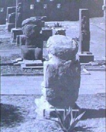
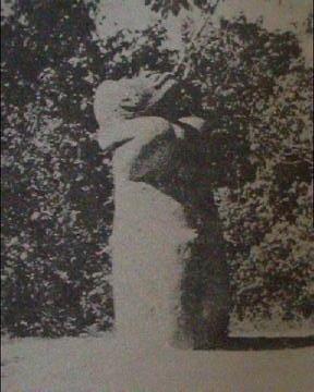
Similar figures can be seen on other Polynesian
islands: Raivavia (left) and Hiv Oa (Right).
(Other
examples of Prehistoric Cross-Culturality)
(List and
Description of Known Rongorongo Texts)
(Easter
Island - Indus Valley Scripts: A Comparison)
(The Prehistoric
Pacific Islanders)
(More
about pre-Columbian America)
(Other
examples of Prehistoric Cross-Culturality)
|