|
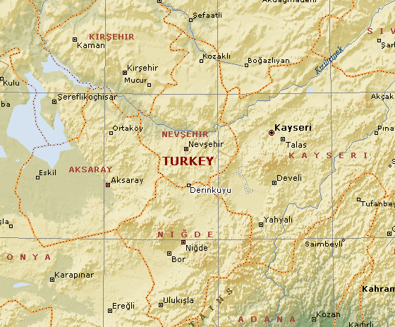
Location:
Between Nevsehir and Nigde,
Turkey. |
Grid Reference:
38� 24' 20" N, 34� 45' 27" E. |
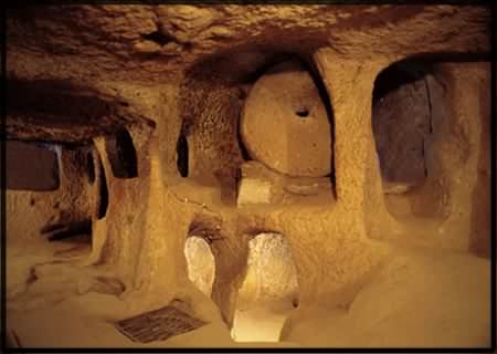
 Derinkuyu:
(Underground City).
Derinkuyu:
(Underground City).
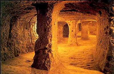 Carved from the
living rock, Derinkuyu is one of
five
inter-connected underground complexes with a
total estimated capacity of
100,000 people. Carved from the
living rock, Derinkuyu is one of
five
inter-connected underground complexes with a
total estimated capacity of
100,000 people.
The historical region of
Cappadocia where Derinkuyu is situated, contains several historical
underground cities, carved out of a unique geological formation, many of
which were
largely re-used by early Christians as hiding places.
Over 200 underground cities at least two
levels deep have been discovered in the area between Kayseri
and Nevsehir, with around 40 of those having at least three levels. The
cities at Derinkuyu and Kaymaklı are two of the best examples of
underground dwellings. (2)
(Map of
site - How to get there)
|
Derinkuyu ('Deep Well'):
Melagobia, Malakopi. |
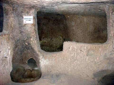
The largest of the Cappadocia underground complexes
is multi-storey (18 storeys, 85m deep), with fresh flowing water, ventilation shafts and
individually separated living quarters or 'apartments', shops, communal
rooms, wells, tombs, arsenals and escape routes. It has the potential to
house up to 20,000 people. The complex was air conditioned throughout, with
52 air shafts discovered so far, one of which is 55m deep.. some
wells were not connected with the surface, presumably in order to protect
the dwellers from poisoning during raids. (1)
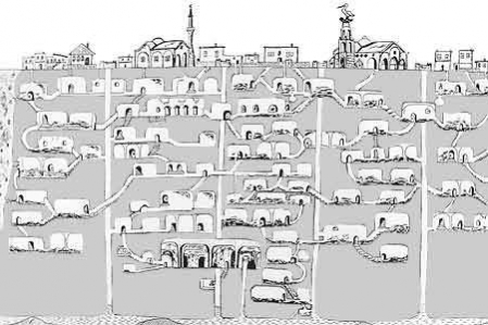
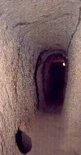
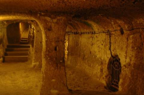
Derinkuyu underground settlement was opened to
visitors in 1965, but so far only 10% can be visited. Entry is through
tunnels that force one to almost crawl on occasion in
order to force invaders into single file... One tunnel on the third level of Derinkuyu is
said to connect to the nearby underground city of Kaymakli (5km distant).
(3)
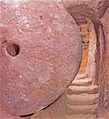
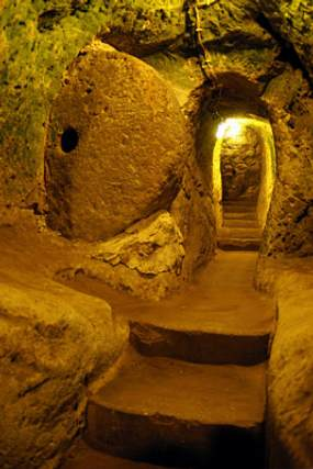
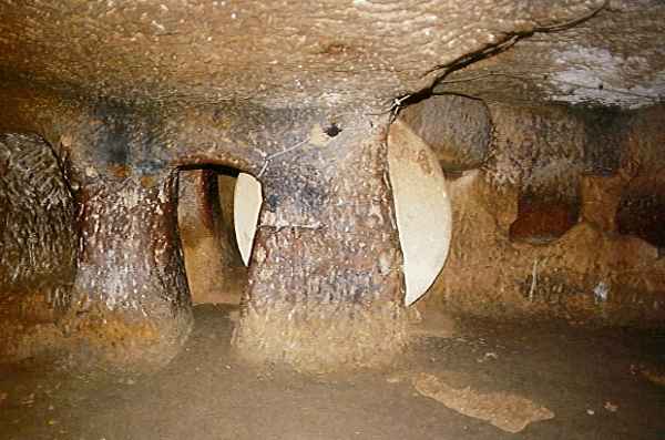
The massive circular doors -
These circular doors are visible at all the local underground sites. They were rolled
across the passages and sealed the citadels from the
inside. At Derinkuyu Each level could also be sealed individually.
The following photos highlight the scale of
the earth-works...
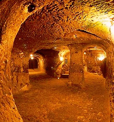
Of
the 18 storeys, only 8 are currently open to
visitors.
When were they constructed?
Wikipedia says of it:
'First built
by the Phrygians in the 8th-7th centuries B.C according to the Turkish
Department of Culture,
the underground city at Derinkuyu was enlarged in the Byzantine era. The oldest written source about
underground cities is the writings of Xenophon (ca. 431 � 355 BC). In his Anabasis he writes that the people living in Anatolia had
excavated their houses underground, living well in accommodations large
enough for the family, domestic animals, and supplies of stored food'.
(Ref:
http://en.wikipedia.org/wiki/Derinkuyu)
Alternatively, they were believed to have
'been constructed at around
1,400 BC by the Hittites'.
http://chopsueyblog.wordpress.com
A Hittite connection is confirmed by archaeology,
but the exact date remains elusive:
In origin, the cities are thought to date back
to Hittite times at least (1900�1200 BC). Hittite-style seals have been
found during excavations and other Hittite remains, such as a lion statue,
have turned up in the area. It is possible that the underground rooms were
used as shelters during the attacks of 1,200 BC, when the Hittite Empire was
destroyed by invaders from Thrace. Later the complexes were enlarged by
other civilizations, and the presence of missionary schools, churches and
wine cellars would seem to indicate that they were used by Christian
communities.
http://www.roughguides.com
|
Other Local Underground Constructions: |
There are another 200 subterranean settlements in the area although only a
few are open to the public.
(2)
 Kaymakli
(Ozluce) Roughly
10
kilometres to the north of Derinkuyu, is smaller and less excavated
but 5 levels are accessible. Kaymakli
(Ozluce) Roughly
10
kilometres to the north of Derinkuyu, is smaller and less excavated
but 5 levels are accessible.
Ozluce Underground settlement is
different from the others in terms of its geological formation and
architectural features. The underground settlement has
tufa
of different colours. There is only one floor in this underground
settlement which has not been completely opened; however, it covers
a very large area.
At
the entrance is a place with two intertwining arches made of basalt.
Access to the main
tufa
stone can be gained through a 15 m long passage, made of rubble
stone. The stone places, which lead to the underground settlement,
are more recent than the rock hollowed places that form the
underground settlement. At the end of this passage there is a
millstone door which is made of hard granite and is 1.75 m in
diameter.
Being the largest area in the underground settlement, the main space
at the entrance consists of two parts. To the right of the main
space are storage rooms, and to the left are living areas. On the
sides of the long corridors are cell-like rooms and on the floor are
traps.
(1)
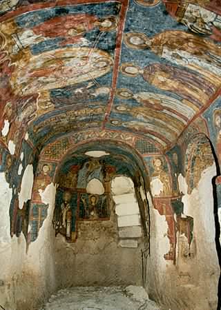
Tatlarin (The Castle). - Christianised underground
settlement.
The village of Tatlarin, located 10 km north of the town of
Acigol, is one of the interesting places in Cappadocia because of
both its underground settlement and churches and the architecture of
its houses. Its underground settlement, located on the hill called
�the castle� by the locals of the village, was first discovered in
1975 and opened to the public in 1991. The size of the chambers in
the underground settlement, only two floors of which can be visited;
the presence of the toilets, which also can only be found at the
Guzelyurt Underground Settlement; the abundance of the depots for
food and of the churches make one think that this place was either a
garrison or a monastic complex rather than an underground
settlement.
(1)
 �zkonak
(Avanos). �zkonak
(Avanos).
A smaller version than that at Derinkuyu.
Built
on the northern slopes of Mt. Idis about 14 km northeast of Avanos in
Turkey has many strata made up of volcanic granite. The larger
areas of the city are connected to each other by tunnels. �zkonak had a
built in communication system of pipes to each of its levels, unlike
Kaymakli and Derinkuyu which have no such communication systems. Each
carved out room had ventilation provided by holes when the city was
closed against enemies.
�zkonak was discovered in 1972 by a
local farmer named Latif Acar, who was curious about where his excess
crop water was disappearing to. Latif discovered an underground room
which, when later excavated, revealed a whole city which could house an
incredible 60,000 people for up to three months. Although only four
floors are now open, the complex contains a total of ten floors, to a
depth of 40m.
(Other Prehistoric Turkish sites)
(Other
Underground Sites)
(A-Z Index)
|