|
Location:
Ica, Off the Pacific coast,
Peru. |
Grid Reference:
14� 49' 60" S, 74� 57' 0" W. |
 Nazca:
(Altered Landscapes).
Nazca:
(Altered Landscapes).
The Nazca desert drawings are probably the largest and best known of
their kind in the world. Their original function is still only guessed
at.
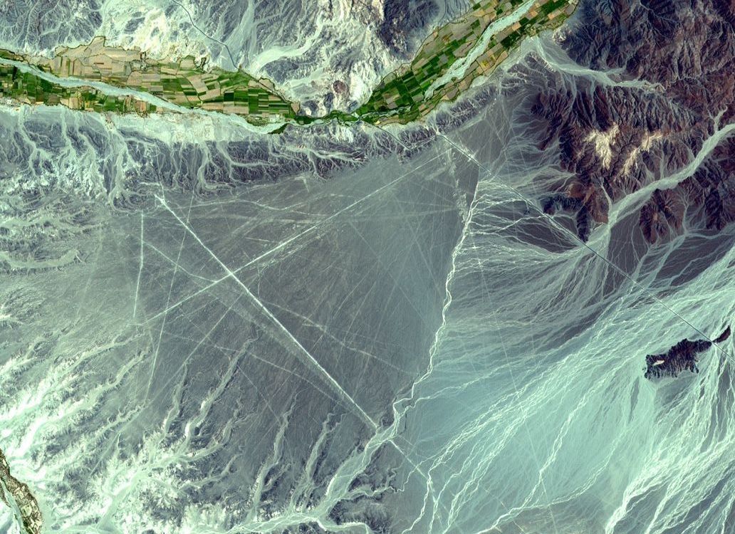
The Nazca valley is a strip of level
desert ground 37 miles long and a mile wide. The enormous drawings were
made by removing the dark purple granite pebbles which cover the floor,
and exposing the light yellow sand beneath. The drawings were first
confirmed when commercial airlines began flights over the Andes.
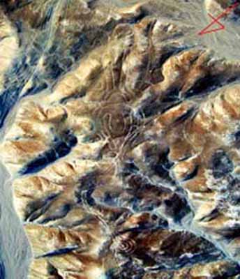
They are clear enough to be viewed by
astronauts aboard Skylab, orbiting 270 miles above Earth.
(Satellite
Map of Nazca)
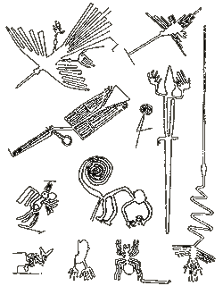
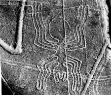
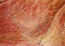
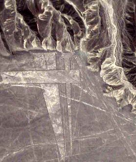
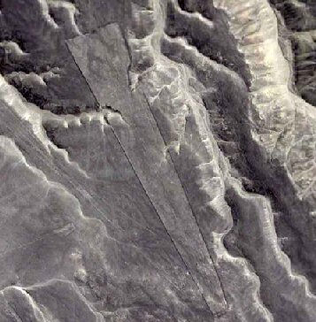
There are essentially
two kinds of drawings at Nazca; Those that are Zoomorphic in nature
(above), and the larger geometric ones, some of which run into the
surrounding hills. The purpose of these designs is still unknown,
although astronomy and a form of ritual worship is suspected.
The Nazca drawings are
largely believed to have been created by the Nazca culture between 200 BC
and 700 AD.
The first detailed
study of the drawings was initiated by the German astronomer and
archaeologist Dr. Maria Reiche. She discovered that the lines, some of which
run for up to five miles, have an average error of no more than 9 minutes of
arc, a deviation of only 4.5 yards per mile. The same figure that is the
limit of accuracy which can be obtained by modern photogram-metric survey
techniques. One drawing represents a thin-limbed monkey, recently identified
as the Spider Monkey from the Amazon jungle, while a remnant of Nazca
pottery has a distinct picture of a Penguin indigenous to either Antarctica
or possibly the Galapagos islands. Another piece of pottery found has the
faces of five girls on it � one white, one red, one black, one brown and one
yellow
(9).
Article:
The
Lost City of Nazca.
In 1983
Italian archaeologist Giuseppe Orefici began a long-term project
to investigate the Nasca. Every year he brings a team of
specialists to South America for 3 intensive months of excavation.
Orefici has concentrated on one remarkable Nasca site, an ancient
city called Cahuachi. He is convinced that this mysterious place
is the key to understanding the line builders.
The
Cahuachi site is huge, extending across 370 acres. The most
impressive monument is this 30 metre high pyramid which dominated
the ancient city. It was built by modifying a natural high point
in the land. As well as the pyramid, there were 40 other
structures, each sculpted from the landscape itself and enhanced
by massive mud brick adobe walls. Extensive plazas and terraces
once covered the land here, nearly 2,000 years ago. Cahuachi lies
75 kilometres inland from the coast of Peru.
The archaeologists eventually unearthed 63
pieces of Nasca fabric, but there is a puzzle. The fabrics come
from different periods of Nasca history and yet they were all
jumbled up together. Many parts are badly decomposed due to
the presence of organic matter and due to exposure to humidity.
These pieces of cloth were laid in a tomb in Cahuachi. They have a
special significance not only as example of textile art but
because the cloth has been sacrificed. It was placed with its
needles and needle cases in this large tomb. The sacrifice of the
fabrics provided important evidence about the kind of place
Cahuachi was in ancient times. The textiles are richly decorated
with images from Nasca mythology and don't appear to be intended
for everyday use. It looks as if the people of Cahuachi were
rather special, a Nasca elite. If the average Nasca citizen wasn't
wearing these fabrics, who was? All the evidence from Orefici's
huge collection of textiles points to one conclusion: the people
of Cahuachi weren't soldiers or citizens, they were priests.
2,000 years ago it would seem like an oasis. We
have the river valley with fields, we have very strong, healthy
people, plenty of food to eat, no warfare. They were fairly short,
long black hair, probably muscular from working very hard and we
have evidence from the skeletal materials, particularly the teeth,
that they were very healthy people and also from those same
skeletons we see no evidence of trauma. There was no warfare here.
One skeleton was found with a powerful blow
to the frontal area of the head, a sharp blow which completely
smashed the nasal septum. It completely smashed the bones of the
face. It had fossilised excrement in the mouth. This isn't the
first time that excrement has been found in the mouth of a mummy,
it is a very unusual discovery.
Recent investigation has linked the lines
directly with water. Although the animal images are the best
known, there are also the 800 straight lines which run for many
kilometres across the pampa. It's been shown that all but one of
these lines start from star-like radial points often marked by a
low mound and every one of those points bordered rivers and
tributaries so if the lines were used for ceremonial walking, as
seems very likely, some Nasca ceremonies were devoted to the
precious sources of water.Water is also intimately connected with
Cahuachi. For much of its length the Nazca river runs underground.
Where it re-emerges the Nasca built their ceremonial capital.
After 17 years of excavation Giuseppe Orefici
has been able to use the hard archaeological evidence to
reconstruct the world of Cahuachi. Moulded from the desert itself
the pyramids and plazas of the lost Nazca city were the site of
ceremony and ritual. It was a city of priests who were guardians
of Nasca culture and religion.
What happened at Cahuachi? Between 300 and
350 A.D. there were two natural disasters. A great, very
powerful flood - we have found the evidence in all the
excavations - and an earthquake, an earthquake which split the
temples in two.
Ref:
http://www.bbc.co.uk/science/horizon/1999/nasca_script.shtml |
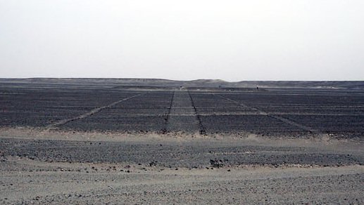
The only reliable sources of water for the people
of the Nazca valley are the high mountains of the Andes. The rivers
flow from their mountain sources for only two brief seasons. At some
point in the past the Nasca built an impressive irrigation system to
control the precious water. 150 kilometres of aqueducts, most of them
underground, criss-crossed the region. The ancient Nasca system is
still in use today. This is a puquio. It gives access to deep,
subterranean tunnels which can become blocked with debris.
(1)
|
Japanese researchers find new giant picture on Peru's Nazca
Plateau
MSN - April 21, 2006
A new giant picture on the
Nazca Plateau in Peru, which is famous for giant patterns that
can be seen from the air, has been discovered by a team of
Japanese researchers.
The image is 65 meters long,
and appears to be an animal with horns. It is thought to have
been drawn as a symbol of hopes for good crops, but there are no
similar patterns elsewhere, and the type of the animal remains
unclear.
The discovery marks the first
time since the 1980s that a picture other than a geometrical
pattern has been found on the Nazca Plateau. The picture was found
by a team of researchers including Masato Sakai, an associate
professor at Yamagata University, after they analyzed images from
a U.S. commercial satellite.
They confirmed it was a
previously undiscovered picture in a local survey in March this
year. It is located south of the Nazca Plateau, and apparently
went undiscovered since few tourist planes pass over the area.
Two parts of the picture, that
appear to be horns, bear close resemblance to those that appear on
earthenware dating from 100 B.C. to A.D. 600, during the time when
the Nazca kingdom flourished, and it is thought that they relate
to fertility rites.
The research team will use
images from the advanced land-observing satellite "Daichi," which
was launched by the Japan Aerospace Exploration Agency in January
this year, to create a distribution map of images on the earth
that can be seen from the air. There is evidence that vehicles had
driven in the area, and part of the picture is destroyed. "We want
to identify all the images, and work to preserve earth pictures
that are gradually being destroyed," Sakai said.
Ref:
http://mdn.mainchi-msn.co |
There is a
theory supported by many anthropologists which says that the societies of
Ancient Peru and the Nasca in particular, were made up of family groups and
that each one of them had a deity, a minor god. Each one of these minor gods
was represented on the pampa. On important dates these family groups went to
the pampa and carried out ceremonies on the lines as an offering to the
supreme gods in the sky. (1)
| Article:
(The
Epoch Times, May 24, 2005).
New designs found that predate the famous
Nazca lines.
A group of about 50 drawings of
giant figures recently discovered in the hills of Peru�s southern
coastal desert near the city of Palpa has been said to predate the
famous Nazca lines nearby.
Mr. Johny Isla, director of the
Andean Institute of Archaeological Studies, said the �geoglyph�
figures appear to have been created by the Paracas communities
between 500 and 400BC, whereas the Nazca culture developed after
50 BC. Mr. Isla and his partner Dr. Markus Reindel from the Dutch
Institute of Archaeology discovered the Paracas figures using
aerial photography and land-based surveys. The figures of humans,
birds, monkeys and cats vary in size from 10m to 50m across, and
are also grouped together in areas up to 60 m to 90 m across.
Most of these
geoglyphs belong to the Nazca culture but our recent studies
demonstrated that there are at least 50 geoglyphs pertaining to
the Paracas culture. These new figures are definitely different
and older than those of the Nazca culture.
�First, the Paracas
figures were drawn on the slopes of the hills, while the Nazca
images were drawn in level areas. Second, the Paracas figures are
smaller and were made in a naturalistic style, while the Nazca
figures are bigger and stylised. Third, the Paracas figures are
mostly arranged in groups, while the Nazca figures are arranged
individually. Finally, it is important to note that not one of the
Paracas figures were repeated in the Nazca iconography,�
One set of figures is known as the �Temple of
Fertility� as one image represents a man, another a woman and the
center image seems to represent a divine figure with a head from
which emanates a series of rays that end in human heads.
Ref:
http://en.epochtimes.com/news/5-5-24/29015.html |
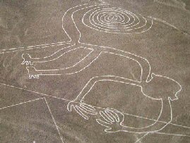
The Nazca Labyrinth:
A five-year
study by British archaeologists has shed new
light on the enigmatic drawings created by
the Nazca people between 100 BC and CE 700
in the Peruvian desert. They discovered an
itinerary so complex they can justify
calling it a labyrinth, and see it as
serving ceremonial progressions.
In the midst
of the study area is a unique labyrinth
originally discovered by Prof Ruggles when
he spent a few days on the Nazca desert back
in 1984. �When I set out along the labyrinth
from its centre, I didn�t have the slightest
idea of its true nature,� Prof Ruggles
explained. �Only gradually did I realize
that here was a figure set out on a huge
scale and still traceable, that it was
clearly intended for walking. Invisible in
its entirety to the naked eye, the only way
of knowing its existence is to walk its 2.7
miles (4.4 km) length through disorienting
direction changes which ended, or began,
inside a spiral formation.
(Link
to Full Article)
�The labyrinth is
completely hidden in the landscape,
which is flat and virtually featureless.
As you walk it, only the path stretching
ahead of you is visible at any given
point. Similarly, if you map it from the
air its form makes no sense at all.�
�But if you walk it,
discovering it as you go, you have a set
of experiences that in many respects
would have been the same for anyone
walking it in the past. The ancient
Nazca peoples created the geoglyphs, and
used them, by walking on the ground.
Sharing some of those experiences by
walking the lines ourselves is an
important source of information that
complements the hard scientific and
archaeological evidence and can really
aid our attempts to make anthropological
sense of it.�
This ground shot is taken along the innermost pathway of the labyrinth directly
towards the central mound.
The line widens out towards its terminus, creating a
false perspective that makes it appear parallel as it stretches away into the
distance.
(Photo
Credit: Clive Ruggles)
(More
about Labyrinths)
Zoomorphic Shapes:
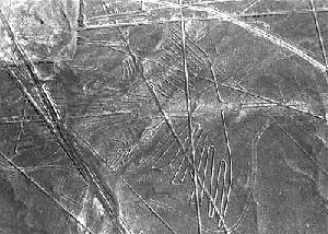
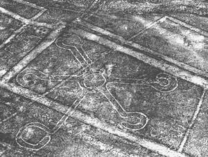
Geometric designs:
|