|
Location:
Cumbria, Near Keswick, England. |
Grid Reference:
54� 36.2' N, 3� 57' W. |
 Castlerigg:
(Stone Circle).
Castlerigg:
(Stone Circle).
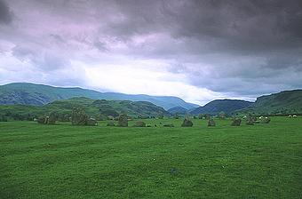
Castlerigg is set 213m (700ft) above sea level. It is thought to
be one of the earliest circles in Britain, and it dates from around 3,200 BC.
(2)
Castlerigg is one of the most dramatically situated circles in
England with views of the Cumbrian mountains on all sides.
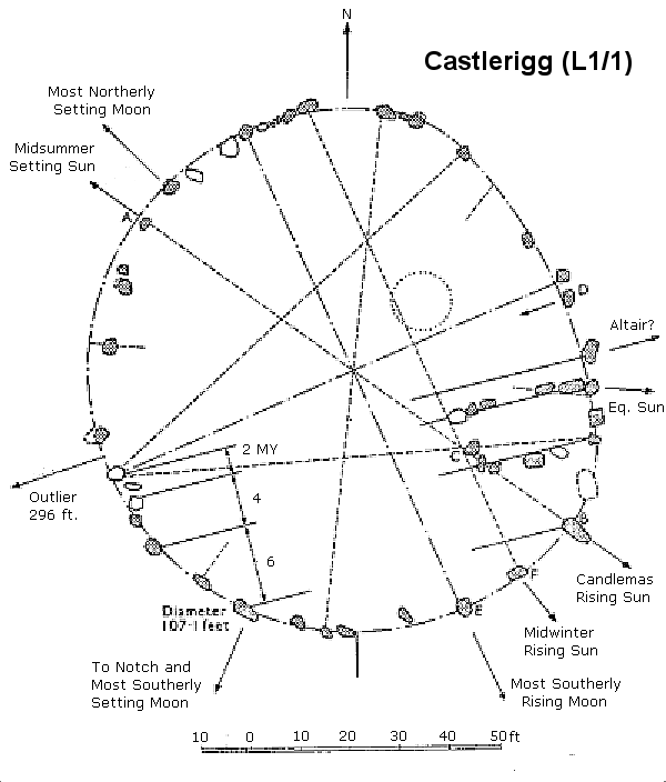
The circle is
important to archaeo-astronomers who have noted that the sunrise
during the Autumn equinox appears over the top of Threlkeld Knott, a
hill 3.5 km to the east. Some stones in the circle have been aligned
with the midwinter sunrise and various lunar positions.
(Click
here for Archaeo-astronomical plan of Castlerigg)
|
Castlerigg:
('Keswick carles, Druids circle). |
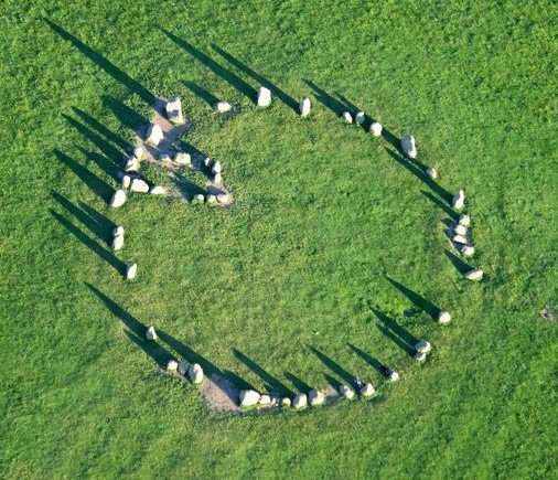
Castlerigg
sits on an ancient track from Borrowdale, a source of stone for axes. The ring
has a flattened arc at the north-east. It also has an entrance defined by
two two tall stones flanking the gap at the exact north.
Around the circumference are traces
of a bank.
Thirty-eight stones are placed in an slightly oval shape of
30m (100ft) in diameter; a further 10 small stones are arranged as a
rectangular enclosure on the south-east side of the ring: this is a feature
unique to Castlerigg, nothing similar being present in other stone circles.
The largest stone of the circle, not far from the enclosure, is 2.5m (8ft
3in) high and it weighs about 16 tons: most of the others, much smaller, are
1 to 1.5m (3-5ft) high. At the north of the ring is an entrance marked by
two slightly bigger stones, and about 90m (295ft) to the south-west, by a
stile at the edge of the field, is a single outlying stone, 0.9m (3ft) high.
(Photo Credit:
Simon Ledinham).
There
are many theories about Castlerigg's function. In Professor Alexander Thom's
opinion, the circle was an astronomical observatory, while Professor Aubrey Burl wrote that
one of Castlerigg's many functions may have been to act as an emporium
connected with the Neolithic stone axe industry in the Langdales. The
close mountainous source of the tuff used for such tools and the stone axes
found at the site support this theory. Probably, Castlerigg had a variety of
functions: easily approached from all directions, it was probably used for
trading, religious ceremonies, and tribal gathering. The rectangular
enclosure was excavated in 1882, and only charcoal was found.
No other excavation has taken place, either within the enclosure or outside.
The Stone
circle at Castle Rigg, Cumbria was one of the most successful
that Alexander Thom came across in terms of combining
astronomical sight-lines with the geometric construction of the
stone circle itself. Thom himself pointed out the remarkable
difficulties in trying to find a site where the skyline yielded
the exact right properties to match the astronomic requirements
and geometry of the circle itself. Although the geometric
connections with the landscape are not immediately visible
today, it has become clear that the builders were endeavouring
to express, control or 'come to terms with something'. In
addition, J. Glover made some interesting comments regarding
Castle Rigg, namely that the specific placement of certain
stones enhanced the shadow-effects caused by the sun at specific
times of the year. As the circle was built onto a gentle slope,
the largest stone creates a shadow nearly a half-mile long at
sunset on midsummer's day.
(More
about Archaeoastronomy)
The site was first brought to public notice in 1725 by the
antiquarian William Stukeley, who wrote that the circle was very entire,
consisting of 50 stones, some very large. But in 1849, in his Guide
to The Lakes, Jonathan Otley reported the present total of stones.
Castlerigg, known to local people as Druid's Circle, is also called
Keswick Carles, apparently because of an old legend telling that the
stones are petrified men, but in fact for a misunderstanding of William
Stukeley's word Carles for Castle.
William Stukeley�s account of his visit to Castlerigg
was published in his Itinerarium Curiosum in 1776, 11 years
after his death. Stukeley�s visit is important, as it is the
earliest written record of the stone circle at Castlerigg:
�for a mile before
we came to Keswick, on an eminence in the middle of a
great concavity of those rude hills, and not far from
the banks of the river Greata, I observed another Celtic
work, very intire: it is 100 foot in diameter, and
consists of forty stones, some very large. At the east
end of it is a grave, made of such other stones, in
number about ten: this is placed in the very east point
of the circle, and within it: there is not a stone
wanting, though some are removed a little out of their
first station: they call it the Carsles, and, corruptly
I suppose, Castle-rig. There seemed to be another larger
circle in the next pasture toward the town. (Stukeley
1969 Vol. II, 48).
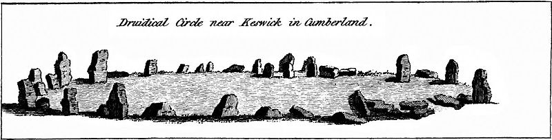
Image drawn by
antiquarian F. Grose in 1783
In the early 20th century,
a single outlying stone was erected by a farmer
approximately 90m to the south west of Castlerigg. This
stone has many linear �scars� along its side from being
repeatedly struck by a plough, suggesting that it was once
buried below the surface and also why the farmer dug it up.
It is not possible to say whether this stone was originally
part of the circle, or just a naturally deposited boulder.
Alignments:
Professor Alexander Thom's
believed that the circle was an astronomical observatory with the tallest stone
(right),
being in line with the November or Samhain (Candlemas) sunrise.
At Castle Rigg, the artist and earth mysteries researcher, John Glover noted
that:
"One of the four alignments defined by the construction lines of the
circle reveals the feat of indicating two solar events in the Neolithic
calendar at opposite ends of the alignment.; the midsummer setting sun and
the Candlemas rising sun. This is made possible by the geometry.
Astoundingly, the builders have made use of another natural feature along
this alignment.
At midsummer's day, the sun appears to set at an angle formed by the
large stone of the alignment and the ridge of Latrigg away to the west. The
exact point of the sunset appears to ave been marked by one of the mounds on
that ridge. If at the time of the sunset, having positioned yourself behind
the large stone, you turn around 180� to face the Candlemas alignment,
'shadow path' as I have termed it, stretches out before you..." (21).
The Castle Rig alignment runs for about 5miles, and along that line, there
are at least ten points of significance: The mound, the first small stone of
the circle, the centre point of the circle where a buried stone has been
found the group of small stones in the cove, the large stone, its shadow
path, the spring, a possible standing stone, a high point on the ridge in
the middle distance by Low Rigg, a holy well dedicated to St. John, another
high point above this, and a the final; notch formed by a river valley high
up on St. Johns common near Little Dod.
(Other
Stone Circles)
(Other
Prehistoric English Sites) |