|
Location: Samaipata, Santa Cruz, Bolivia. |
Grid Reference:
18� 10'
42" S , 63� 49' 11" W. |
  El Fuerte de Samaipata:
('Fort' Samaipata).
El Fuerte de Samaipata:
('Fort' Samaipata).
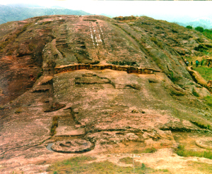
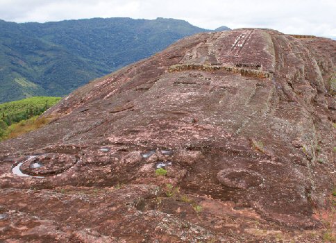
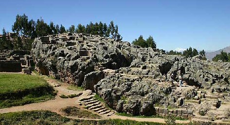
The carved hill of El Fuerte de Samaipata is one
of Bolivia's archaeological 'Jewels'. It is also one of the largest
examples of its kind in the world.
For over a thousand years this site served as a ceremonial centre for
various pre-Colombian cultures, ultimately including the Inca who
erected great temples and turned the site into the capital of the
eastern most reaching province of their empire.
In the words of UNESCO: "The
huge sculptured rock, dominating the town below, is a unique
testimony to pre-Hispanic and beliefs, and has no
parallel anywhere in the Americas."
The site gained
fame when Erik Von Daniken proposed in the 1960's that it was
designed as a landing site for
UFO's. To his credit, he played a major part in bringing this site
to the attention of modern researchers and travellers alike.
|
Samaipata -' The Height to Rest' |
Samaipata is a Quechua word that means: 'The Height to Rest'. The
Title El Fuerte, 'The Fort' is deceptive being named by the
Spanish in relation to the fact that it was an Inca stronghold
at the time they found it.
Chronology of the Site:
Archaeology of the site has revealed that
several phases of occupation were present at Samaipata. Before the
Spanish were the Inca, and beneath the foundations of the Inca works
evidence of previous cultural works was found, proving that the
site was in use a long time before the might Inca.
(5) So who
were the people that originally carved the hill..? The site is now generally considered to be a pre-Incan site, built
by the
Chan� people, a pre-Inca culture of
Arawak origin, (3)
who migrated from Guyana approximately 2,500 years ago.
(6)
It is suggested that the first engravings at El Fuerte were
undertaken during the Mojocoyas period (AD 200 � 800)
(7).
Unfortunately, the exact
chronology of the site is yet to be determined for the period
between the
Chan� and the Inca, but the evidence suggests that there is more
than one building phase at Samaipata.
The site was
later occupied by the Inca who
used it as their most advanced post of the Empire, of which it
marked the frontier from the late 15th century until its fall in
1530. It was the administrative centre in charge of maintaining
the order of the Inca in the region, but its principal function
was keeping at bay the frequent invasion attempts of the Guarani
Indians. (1)
They
gave it the name of "Samaipata", which is Quechua (language of the
Inca�s) and stands for 'The Height to Rest' or 'Rest in the heights',
and they added several classic Inca-style masonry constructions
to the complex. Around 1540 the Spanish arrived and encountered an Inca fortress. They renamed the site "El Fuerte" or "The Fortress",
and
deserted the site around 1629 when they founded the settlement known
today as Samaipata a few Km away.
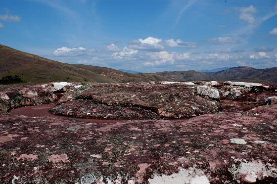
Features of El- Fuerte:
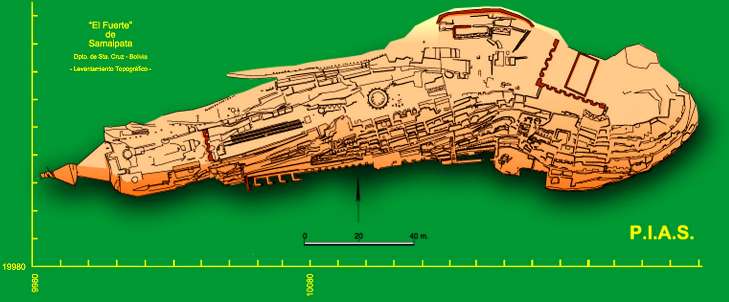
The site consists of
two distinct areas; The carved mountain top named 'El Fuerte'
(above), and the 'administrative' area below, composed of
buildings and courtyards.
Starting at the
western end, the rock has been carved to reveal the outline of
three felines (jaguars). The second is out of shot (right,
foreground), and is greatly eroded. The third is placed further
ahead within what appears to be the zig-zag motif common in Inca
and Tiahuanacan art.
This is the
third of three prominent carved Jaguar emblems at the western
end of the site.
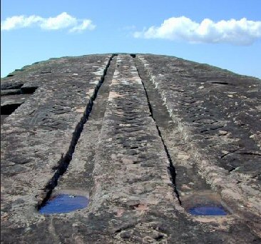
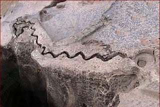
The ascent along the
crest of the hill invariably leads one to one of the most important feature of El Fuerte. El Cascabel,
which can be translated as 'The Rattle'.
The two parallel lines
are oriented to the eastern sky at a position of azimuth
71� and an altitude of about 6.75� .
|
'The orientation of the carved trail
is the direction of the rise of the
Pleiades at about 1AD. An observer at the top of the
hill could see
the rising of the Pleiades at around 500AD, and also
the rising of Regulus in 600AD. The alignment of the
8 pits points to the
rise of the Pleiades at 500BC and of Aldebaran at
500AD. The long rectilinear engraving
near the seats complex to the East
matches the rise of the Pleiades at about 500BC.
If we consider that the Pleiades cluster ('Collca'
in the quechua or 'Qutu' in the aymara languages)
was important in the Andean world as a celestial
signal for sowing (mainly maise) or for the
prediction of yields, then it is possible to think
that the alignments found at Samaipata were devised
for the observation of this star cluster.
Accordingly, the monument should have been built
between 1AD and 500 or 600AD. Perhaps the eight pits
were used first and the 'cascabel' later on, as a
more recent construction. Of course only the
archaeological research may work out a precise
dating for the monument.
(2) |
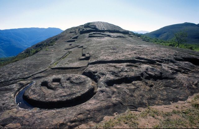
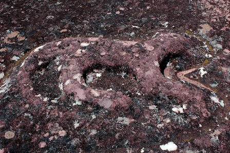
At the top of the stone there is a circle
of 12 seats with a set of 3 seats in the middle. Locals call this
the "Coro de los Sacerdotes" or "Choir of Priests".
The carved circular seating
arrangement known as the Coro de los Sacerdotes (Choir
of the Priests) is carved at the top pf the rocky
oucrop. Here, with an most incredible
panoramic view, 12 seats were deeply into the hilltop in a circle (7m in outside diameter).
Within the circle of 12 is another set of seats, which
are placed back-to-back and face outward toward the 12
seats. The circle includes triangular and rectangular niches
cut into its walls. The structure bears vague similarities
to the 'Cuzco Sundial' or the 'Eye of the Jaguar' at Cuzco.
(More
about Cuzco)
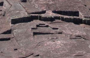
Most of the southern face of the rock was
originally dominated by a series of at least five
temples or sanctuaries, of which only the
niches cut into their walls survive. These niches
vary widely in size, shape, and orientation, but their
design indicates the temples were built in the Inca period.
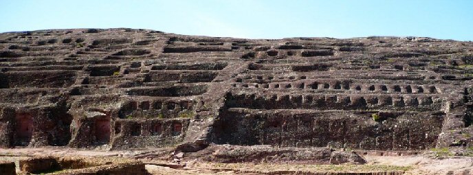
It has also
been suggested that the southern face shows signs of
quarrying, an idea which comes from fact that the works have
been left in a partial state of construction.
One wonders
what the final design would have looked like had they been
left longer to finish it.
An image
of the Sun-god... or alternatively...
Dare I
say it...A Phallus...?
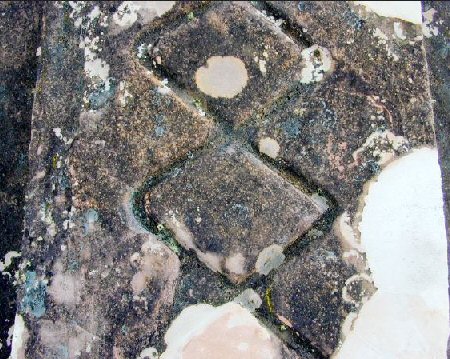
The Chincana:
About 100m from the site is the yet unexplored Chincana. The
Chincana, are tunnel systems, such as the one on Lake Titicaca,
which is now exposed. The leading historians
believe it was an escape route in case of attack or a
tunnel that comes from within the stone complex above, while other
suggestions include it
being a cemetery, or a mini-version of a 'cenote' for
worshipping at.
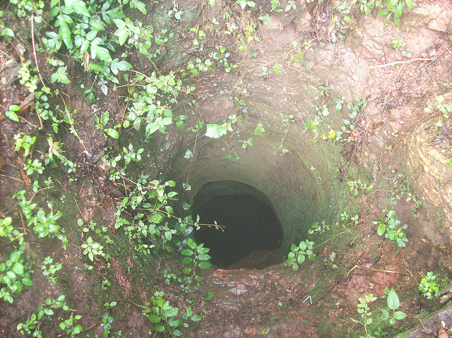
The hole is
carved into the rock and is just wide enough for a person.
David Hatcher Childress Has the following to say about it:
|
Extract From David Hatcher
Childress:
The Camino de la
Chinchana was a tunnel that began as a two-meter
opening to a pit that went straight down for about 6
meters. Once one had made the first descent down to the
floor of the pit, something that would take a rope or a
ladder, then one would find himself standing in a tunnel
that was high enough and wide enough for a man to stand
without stooping. This tunnel then descended downhill
from the fort, apparently going in a northwest
direction.
According to the caretaker of Samaipata, the tunnel had
been explored once by Bolivian archaeologists who had
entered the pit with a rope and had advanced some 100
meters or more into the tunnel. The air became stale and
a small cave-in had blocked a portion of the tunnel. Without proper breathing
gear, the team was unable to advance any farther into
the earth. (4)
|
Quenko:
The archaeological
site of Quenko, close to Cuzco has several similarities to the
Samaipata carvings. It was an Inca religious centre with a large
semi-circular ampitheatre and seats of stone. It is thought to have
been a sacred place where ceremonies to honour the sun, moon and
stars were carried out.
(Bolivia
Homepage)
(Pre-Columbian
America's Homepage)
|